Location
Latitude: |
39-22-14.6670N (39.370741) |
Longitude: |
101-41-55.4420W (-101.698734) |
Elevation: |
3657.6 feet MSL (1115 m MSL) |
Magnetic Variation: |
5.8 E (as of April 2024 from WMM2020 model) |
Time Zone: |
UTC -7.0 (Standard Time) UTC -6.0 (Daylight Savings Time) |
From City: |
02 N.M. N of Goodland, Kansas |
Found On: |
Wichita Chart |
FAA Region: |
ACE |
Contacts
Manager: |
Publicly owned: |
| ANDREW FINZEN 204 W. 11TH ST. GOODLAND, KS 67735 785-890-4500 |
CITY OF GOODLAND P. O. BOX 59 GOODLAND, KS 67735 785-890-4500 |
Operations
Airport Status: |
Operational |
Facility Use: |
Public |
Type: |
Airport |
Activation Date: |
04/1940 |
Control tower: |
No |
Attendance (Months/Days/Hours): |
Months/Days/Hours ALL/ALL/DALGT |
Boundary ARTCC: |
ZDV (Denver) |
Responsible ARTCC: |
ZDV (Denver) |
Lighting Schedule: |
SEE RMK |
Segmented Circle Indicator: |
No |
Traffic Pattern Altitude (MSL): |
4658 feet (1420 m) |
NOTAMs Facility: |
GLD |
NOTAM-D Service: |
Yes |
International Airport of Entry: |
No |
Customs Landing Rights: |
No |
Military Landing Rights: |
Yes |
Civil/Military Joint Use: |
No |
Based Aircraft
| Single Engine: | 23 |
| Multi Engine: | 3 |
Annual Operations (as of 09/18/2022)
| Total Operations: | 43000 | |
| Air Taxi: | 400 | 0.9% |
| GA Local: | 10000 | 23.3% |
| GA Itinerant: | 32000 | 74.4% |
| Military Aircraft: | 600 | 1.4% |
Communications
| CTAF: | 122.800 |
| Unicom: | 122.800 |
| ASOS: | 121.025 (785-899-6591) |
- APCH/DEP CTL SVC PRVDD BY DENVER ARTCC (ZDV) ON FREQS 132.7/226.675 (GOODLAND RCAG).
Fixed Based Operators (FBOs) & Fuel
(Click on a business for detail)
Please help us keep this information up to date. This is a FREE SERVICE just like everything else on Airport Guide! If you see that a business needs to be added, modified, or deleted please fill out our Update Form.
To add, modify, or delete a business click here.
Please help us keep this information up to date. This is a FREE SERVICE just like everything else on Airport Guide! If you see that a business needs to be added, modified, or deleted please fill out our Update Form.
Area Code: 785 |
| Business Name | Frequency | Phone | Fuel Grade |
|---|---|---|---|
| Butterfly Aviation, Inc.
Update FBO info |
Unicom 122.95 | 899-7531 | 100LL, Jet A |
Flight Service Stations
| Primary | Alternate | |
| FSS on Field: | N | |
| FSS Name (ID): | Wichita(ICT) | |
| Frequency: | ||
| Toll Free Phone: | 1-800-WX-BRIEF |
Instrument Procedures / Charts
FAA Terminal Procedures valid from 0901Z 03/21/24 to 0901Z 04/18/24.
There are various types of charts available for an airport. They are listed in the Page Type column. Here is a legend for those types:
APD - Airport Diagram
DP - Departure Procedure Charts
HOT - Hot Spots
IAP - Instrument Approach Procedure Charts
MIN - Minimums
STAR - Standard Terminal Arrival Charts
| Page Type | Page Name | Volume | Action Since Last Cycle |
|---|---|---|---|
| APD | AIRPORT DIAGRAM | NC-2 | |
| IAP | ILS OR LOC RWY 30 | NC-2 | |
| IAP | RNAV (GPS) RWY 12 | NC-2 | |
| IAP | RNAV (GPS) RWY 23 | NC-2 | |
| IAP | RNAV (GPS) RWY 30 | NC-2 | |
| IAP | VOR RWY 30 | NC-2 | |
| MIN | ALTERNATE MINIMUMS | NC-2 | |
| MIN | TAKEOFF MINIMUMS | NC-2 |
Terminal Procedures are only available for airports in several countries with more being added all the time. If you are looking for a specific country's charts, please send an email to support(at)airportguide.com stating the country name. This will be used to prioritize the implementation.
Navigation Aids (Navaids) near GLD
| Dist (NM) | ID | Morse Code | Name | Type | Freq | True Hdg | Mag Hdg |
|---|---|---|---|---|---|---|---|
| 1.1 | GLD | _ _ . . _ . . _ . . | Goodland | VORTAC | 115.10 | 16 | 10 |
| 6.5 | GL | _ _ . . _ . . | Shugr | NDB | 414 | 135 | 129 |
| 21.7 | SYF | . . . _ . _ _ . . _ . | St Francis | NDB | 386 | 351 | 345 |
| 28.2 | ITR | . . _ . _ . | Kit Carson | NDB | 209 | 254 | 248 |
| 31.3 | JDM | . _ _ _ _ . . _ _ | Wheatfield | NDB | 408 | 74 | 68 |
| 43.9 | OEL | _ _ _ . . _ . . | Oakley | NDB | 380 | 110 | 104 |
| 60.3 | OIN | _ _ _ . . _ . | Oberlin | NDB | 341 | 62 | 57 |
| 65.5 | TQK | _ _ _ . _ _ . _ | Scott City | NDB | 256 | 144 | 138 |
| 68.7 | HLC | . . . . . _ . . _ . _ . | Hill City | VORTAC | 113.70 | 95 | 90 |
| 71.4 | MCK | _ _ _ . _ . _ . _ | Mc Cook | VOR-DME | 115.30 | 45 | 40 |
| 72.0 | MCK | _ _ _ . _ . _ . _ | Mc Cook | FAN MARKER | 47 | 42 | |
| 72.9 | TXC | _ _ . . _ _ . _ . | Thurman | VORTAC | 112.90 | 286 | 280 |
| 74.1 | HCT | . . . . _ . _ . _ | Hayes Center | VORTAC | 117.70 | 28 | 22 |
| 83.0 | AKO | . _ _ . _ _ _ _ | Akron | VOR-DME | 114.40 | 305 | 299 |
| 84.2 | LAA | . _ . . . _ . _ | Lamar | VOR-DME | 116.90 | 213 | 207 |
| 88.5 | NRN | _ . . _ . _ . | Norton | NDB | 230 | 70 | 65 |
| 90.0 | GGF | _ _ . _ _ . . . _ . | Grant | NDB | 359 | 359 | 353 |
| 90.4 | CSB | _ . _ . . . . _ . . . | Harry Strunk | NDB | 389 | 51 | 46 |
| 95.5 | HGO | . . . . _ _ . _ _ _ | Hugo | VOR-DME | 112.10 | 250 | 244 |
| 98.3 | GCK | _ _ . _ . _ . _ . _ | Garden City | VORTAC | 113.30 | 152 | 147 |
Nearby Airports with Fuel
Notices to Airmen (NOTAMS)
Remarks
| A110-1 | TWY A2 ONLY AVBL FOR ACFT OVER 12500 LBS. |
| A110-2 | FOR CD CTC DENVER ARTCC ON FREQ. IF UNA, CTC FSS ON FREQ VIA RCO. IF UNA, CTC DENVER ARTCC AT 303-651-4257. |
| A17 | FOR SVC CALL 785-890-7531 (DAY) OR 785-443-1328 (NIGHT). |
| A30A-23 | TURN-AROUND DOES NOT HAVE CLNC FOR HLDG. |
| A30A-30 | CALM WIND RWY. |
| A42-17 | 17/35 YELLOW CONES MARKERS AT THR. |
| A43-05 | PAPI UNUSBL BYD 8 DEGS L OF CNTRLN. |
| A81-APT | ACTVT MALSR RWY 30; REIL RWY 12; PAPI RWY 05 & 23; MIRL RWY 05/23 & 12/30 - CTAF. |
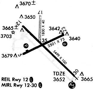
Runways
Runway Summary
| Runways: | 05/23 12/30 17/35 |
| Longest Runway: | 12/30 is 5499 ft (1676 m) long |
| Runways with an Instrument Approach: | 30 |
GLD Airport Runway Details
| Runway 05/23 | 4001 ft x 75 ft (1220 m x 23 m) | |
| Runway Length Source: | 3RD PARTY SURVEY as of 10/18/2021 | |
| Surface: | Asphalt - Good condition - No special surface treatment | |
| Runway Pavement Class: | 5 /F/C/Y/U | |
| Runway Edge Lights: | Medium Intensity | |
Runway Weight Bearing Capacity (in thousands of pounds) |
||
| Single Wheel Landing Gear: | 12.5 | |
Runway 05 |
Runway 23 |
|
Elevation: |
3657.6 | 3634.7 |
Latitude: |
39-22-06.6642N | 39-22-24.5786N |
Longitude: |
101-42-18.5970W | 101-41-33.1857W |
|
Runway True Alignment: |
063 | 243 |
Glide Path Angle: |
3.0 degrees | 3.0 degrees |
Traffic Pattern: |
Left | |
Runway Markings Type: |
Nonprecision Instrument | Nonprecision Instrument |
Runway Markings Condition: |
Fair | Fair |
Object at End: |
ROAD | TREE |
Object Height: |
15 | 25 |
Distance from End: |
200 | 505 |
Object Centerline Offset: |
282 ft. right of centerline | 312 ft. left of centerline |
Visual Glide Slope Indicators: |
4-Light PAPI On Left Side Of Runway | 4-Light PAPI On Left Side Of Runway |
Threshold Crossing Height: |
36 | 42 |
| Runway 12/30 | 5499 ft x 100 ft (1676 m x 30 m) | |
| Runway Length Source: | 3RD PARTY SURVEY as of 10/18/2021 | |
| Surface: | Asphalt - Good condition - No special surface treatment | |
| Runway Pavement Class: | 11 /R/C/X/U | |
| Runway Edge Lights: | Medium Intensity | |
Runway Weight Bearing Capacity (in thousands of pounds) |
||
| Single Wheel Landing Gear: | 30.0 | |
| Dual Wheel Landing Gear: | 48.0 | |
Runway 12 |
Runway 30 |
|
Elevation: |
3645.7 | 3653.4 |
Latitude: |
39-22-29.0003N | 39-21-51.0024N |
Longitude: |
101-42-18.2835W | 101-41-28.2339W |
|
Runway True Alignment: |
134 | 314 |
ILS Type: |
ILS/DME | |
Glide Path Angle: |
0.0 degrees | 0.0 degrees |
Traffic Pattern: |
Left | Left |
Runway Markings Type: |
Precision Instrument | Precision Instrument |
Runway Markings Condition: |
Good | Good |
Object at End: |
BLDG | |
Object Height: |
30 | |
Distance from End: |
906 | |
Object Centerline Offset: |
282 ft. right of centerline | 312 ft. left of centerline |
Approach Light System: |
1,400 Foot Medium Intensity Approach Lighting System With Runway Alignment Indicator Lights | |
REIL: |
Yes |
| Runway 17/35 | 1754 ft x 40 ft (535 m x 12 m) | |
| Runway Length Source: | 3RD PARTY SURVEY as of 10/18/2021 | |
| Surface: | Asphalt - Good condition - No special surface treatment | |
Runway 17 |
Runway 35 |
|
Elevation: |
3639.6 | 3643.2 |
Latitude: |
39-22-35.7818N | 39-22-18.4477N |
Longitude: |
101-42-01.3382W | 101-42-01.1998W |
|
Runway True Alignment: |
180 | 360 |
Glide Path Angle: |
0.0 degrees | 0.0 degrees |
Traffic Pattern: |
Left | Left |
Runway Markings Condition: |
Fair | Fair |
Object at End: |
POLE | TOWER |
Object Height: |
62 | 80 |
Distance from End: |
378 | 1775 |
Object Centerline Offset: |
282 ft. right of centerline | 312 ft. left of centerline |
Services
Airframe Repair: |
Major |
Powerplant Repair: |
Major |
Bottled Oxygen: |
Low Pressure |
Bulk Oxygen: |
Low Pressure |
Fuel Available: |
100LL, Jet A |
Landing Fees: |
No |
Parking: |
Hangars and tiedowns available |
Maps & Diagrams
GLD Sectional
Flight Planning
at skyvector.com
at skyvector.com