Location
Latitude: |
36-42-01.0670N (36.700296) |
Longitude: |
076-54-07.6880W (-76.902136) |
Elevation: |
40.3 feet MSL (12 m MSL) |
Magnetic Variation: |
10.5 W (as of April 2024 from WMM2020 model) |
Time Zone: |
UTC -5.0 (Standard Time) UTC -4.0 (Daylight Savings Time) |
From City: |
02 N.M. NE of Franklin, Virginia |
Found On: |
Washington Chart |
FAA Region: |
AEA |
Contacts
Manager: |
Publicly owned: |
| TREVELYN LINTON 32470 JOHN BEVERLY ROSE DR FRANKLIN, VA 23851 757-562-8764 |
CITY OF FRANKLIN P O BOX 179 FRANKLIN, VA 23851 757-562-8561 |
Operations
Airport Status: |
Operational |
Facility Use: |
Public |
Type: |
Airport |
Activation Date: |
08/1937 |
Control tower: |
No |
Attendance (Months/Days/Hours): |
Months/Days/Hours ALL/ALL/0800-1700 |
Boundary ARTCC: |
ZDC (Washington) |
Responsible ARTCC: |
ZDC (Washington) |
Lighting Schedule: |
SEE RMK |
Segmented Circle Indicator: |
No |
Traffic Pattern Altitude (MSL): |
1040 feet (317 m) |
NOTAMs Facility: |
FKN |
NOTAM-D Service: |
Yes |
International Airport of Entry: |
No |
Customs Landing Rights: |
No |
Military Landing Rights: |
Yes |
Civil/Military Joint Use: |
No |
Based Aircraft
| Single Engine: | 12 |
Annual Operations (as of 12/31/2021)
| Total Operations: | 4728 | |
| Air Taxi: | 192 | 4.1% |
| GA Local: | 1422 | 30.1% |
| GA Itinerant: | 1784 | 37.7% |
| Military Aircraft: | 1330 | 28.1% |
Communications
| CTAF: | 122.800 |
| Unicom: | 122.800 |
| Approach: | NORFOLK 127.9 127.9 |
| Departure: | NORFOLK 127.9 127.9 |
| AWOS-3PT: | 124.675 (757-562-8765) |
Fixed Based Operators (FBOs) & Fuel
(Click on a business for detail)
Please help us keep this information up to date. This is a FREE SERVICE just like everything else on Airport Guide! If you see that a business needs to be added, modified, or deleted please fill out our Update Form.
To add, modify, or delete a business click here.
Please help us keep this information up to date. This is a FREE SERVICE just like everything else on Airport Guide! If you see that a business needs to be added, modified, or deleted please fill out our Update Form.
Area Code: 757 |
| Business Name | Frequency | Phone | Fuel Grade |
|---|---|---|---|
| Franklin Municipal Airport
Update FBO info |
Unicom 122.8 | 562-8764 | 100LL, Jet A |
| Robins Aviation Co.
Update FBO info |
Unicom 122.8 | 488-9586, 562-6986 |
Flight Service Stations
| Primary | Alternate | |
| FSS on Field: | N | |
| FSS Name (ID): | Leesburg(DCA) | |
| Frequency: | ||
| Toll Free Phone: | 1-800-WX-BRIEF |
Instrument Procedures / Charts
FAA Terminal Procedures valid from 0901Z 03/21/24 to 0901Z 04/18/24.
There are various types of charts available for an airport. They are listed in the Page Type column. Here is a legend for those types:
APD - Airport Diagram
DP - Departure Procedure Charts
HOT - Hot Spots
IAP - Instrument Approach Procedure Charts
MIN - Minimums
STAR - Standard Terminal Arrival Charts
| Page Type | Page Name | Volume | Action Since Last Cycle |
|---|---|---|---|
| IAP | RNAV (GPS) RWY 09 | NE-3 | |
| IAP | RNAV (GPS) RWY 27 | NE-3 | |
| MIN | ALTERNATE MINIMUMS | NE-3 | |
| MIN | TAKEOFF MINIMUMS | NE-3 |
Terminal Procedures are only available for airports in several countries with more being added all the time. If you are looking for a specific country's charts, please send an email to support(at)airportguide.com stating the country name. This will be used to prioritize the implementation.
Navigation Aids (Navaids) near FKN
| Dist (NM) | ID | Morse Code | Name | Type | Freq | True Hdg | Mag Hdg |
|---|---|---|---|---|---|---|---|
| 5.4 | FKN | . . _ . _ . _ _ . | Franklin | VORTAC | 110.60 | 278 | 288 |
| 13.6 | RK | . _ . _ . _ | Waley | NDB | 249 | 116 | 127 |
| 17.6 | AKQ | . _ _ . _ _ _ . _ | Wakefield | NDB | 274 | 344 | 355 |
| 19.7 | CVI | _ . _ . . . . _ . . | Cofield | VORTAC | 114.60 | 175 | 185 |
| 25.7 | ELQ | . . _ . . _ _ . _ | Emporia | NDB | 261 | 259 | 269 |
| 25.8 | EY | . _ . _ _ | Chesi | NDB | 233 | 103 | 114 |
| 29.6 | FAF | . . _ . . _ . . _ . | Felker | NDB | 226 | 27 | 38 |
| 32.4 | OR | _ _ _ . _ . | Ingle | NDB | 329 | 74 | 85 |
| 32.5 | PJS | . _ _ . . _ _ _ . . . | Henry | NDB | 375 | 36 | 47 |
| 33.3 | NGU | _ . _ _ . . . _ | Chambers | TACAN | 113.95 | 64 | 75 |
| 34.8 | LFI | . _ . . . . _ . . . | Langley | TACAN | 112.30 | 48 | 59 |
| 35.6 | ORF | _ _ _ . _ . . . _ . | Norfolk | VORTAC | 116.90 | 70 | 81 |
| 39.1 | HPW | . . . . . _ _ . . _ _ | Hopewell | VORTAC | 112.00 | 344 | 355 |
| 39.2 | LLW | . _ . . . _ . . . _ _ | Woodville | NDB | 254 | 131 | 142 |
| 41.8 | RZZ | . _ . _ _ . . _ _ . . | Rapids | NDB | 407 | 248 | 258 |
| 42.2 | NTU | _ . _ . . _ | Oceana | TACAN | 116.60 | 79 | 90 |
| 43.6 | EDE | . _ . . . | Edenton | NDB | 265 | 158 | 169 |
| 44.0 | ECG | . _ . _ . _ _ . | Elizabeth City | VOR-DME | 112.50 | 126 | 137 |
| 45.8 | HCM | . . . . _ . _ . _ _ | Harcum | VORTAC | 108.80 | 11 | 22 |
| 46.3 | CF | _ . _ . . . _ . | Pubbs | NDB | 392 | 325 | 335 |
Nearby Airports with Fuel
Notices to Airmen (NOTAMS)
Remarks
| A110-1 | DEER ON AND INVOF ARPT. |
| A110-2 | PSBL TFC FM THE SOUTHAMPTON MEMORIAL HELIPAD 2 NM W OF ARPT. |
| A110-3 | DRAINAGE DITCHES NEXT TO RWY & TWYS. |
| A110-4 | FOR CD CTC NORFOLK APCH AT 757-464-0757. |
| A110-5 | ARPT FBO CLSD SAT AND SUN. |
| A16 | CTC 757-562-8575 FOR AFTER HOUR EMERGENCIES. |
| A43-27 | RWY 27 PAPI UNUSABLE BYD 1 NM FM THR. |
| A58-27 | 4 FT HIGH FENCE 139 FT FM RWY END, 242 FT L ON APCH. |
| A81-APT | ACTVT MIRL 09/27 - CTAF. |
| E111 | IN OPERATION PRIOR TO 1959. |
| E147 |
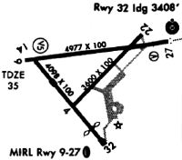
Runways
Runway Summary
| Runways: | 09/27 |
| Longest Runway: | 09/27 is 4977 ft (1517 m) long |
| Runways with an Instrument Approach: |
FKN Airport Runway Details
| Runway 09/27 | 4977 ft x 100 ft (1517 m x 30 m) | |
| Runway Length Source: | 3RD PARTY SURVEY as of 05/27/2019 | |
| Surface: | Asphalt - Good condition - Saw-cut or plastic grooved | |
| Runway Edge Lights: | Medium Intensity | |
Runway 09 |
Runway 27 |
|
Elevation: |
33.3 | 40.3 |
Latitude: |
36-41-57.2009N | 36-42-04.9308N |
Longitude: |
076-54-37.8665W | 076-53-37.5096W |
|
Runway True Alignment: |
081 | 261 |
Glide Path Angle: |
3.0 degrees | 3.0 degrees |
Traffic Pattern: |
Left | Left |
Runway Markings Type: |
Nonprecision Instrument | Nonprecision Instrument |
Runway Markings Condition: |
Fair | Fair |
Object at End: |
TREE | TREE |
Object Height: |
28 | 59 |
Distance from End: |
632 | 1308 |
Object Centerline Offset: |
200 ft. right of centerline | 297 ft. left of centerline |
Visual Glide Slope Indicators: |
2-Light PAPI On Left Side Of Runway | 2-Light PAPI On Left Side Of Runway |
Threshold Crossing Height: |
40 | 40 |
Services
Airframe Repair: |
None |
Powerplant Repair: |
None |
Bottled Oxygen: |
None |
Bulk Oxygen: |
None |
Fuel Available: |
100LL |
Landing Fees: |
No |
Parking: |
Tiedowns available |
Maps & Diagrams
FKN Sectional
Flight Planning
at skyvector.com
at skyvector.com