Location
Latitude: |
32-56-19.7740N (32.938826) |
Longitude: |
095-16-43.9230W (-95.278868) |
Elevation: |
513.4 feet MSL (156 m MSL) |
Magnetic Variation: |
1.8 E (as of April 2024 from WMM2020 model) |
Time Zone: |
UTC -6.0 (Standard Time) UTC -5.0 (Daylight Savings Time) |
From City: |
02 N.M. SE of Winnsboro, Texas |
Found On: |
Dallas-Ft Worth Chart |
FAA Region: |
ASW |
Contacts
Manager: |
Publicly owned: |
| JOEY LACAZE 501 SOUTH MAIN WINNSBORO, TX 75494 903-767-1060 |
CITY OF WINNSBORO 501 SOUTH MAIN WINNSBORO, TX 75494 903-342-3654 |
Operations
Airport Status: |
Operational |
Facility Use: |
Public |
Type: |
Airport |
Activation Date: |
05/1971 |
Control tower: |
No |
Attendance (Months/Days/Hours): |
Months/Days/Hours Unattended |
Boundary ARTCC: |
ZFW (Fort Worth) |
Responsible ARTCC: |
ZFW (Fort Worth) |
Lighting Schedule: |
SEE RMK |
Segmented Circle Indicator: |
Yes |
Traffic Pattern Altitude (MSL): |
1513 feet (461 m) |
NOTAMs Facility: |
FTW |
NOTAM-D Service: |
Yes |
International Airport of Entry: |
No |
Customs Landing Rights: |
No |
Based Aircraft
| Single Engine: | 9 |
| GA Helicopters: | 1 |
Annual Operations (as of 10/08/2022)
| Total Operations: | 2900 | |
| GA Local: | 2200 | 75.9% |
| GA Itinerant: | 700 | 24.1% |
Communications
| CTAF: | 122.900 |
| Approach: | LONGVIEW 128.75 128.75 FORT WORTH ARTCC |
| Departure: | LONGVIEW 128.75 128.75 FORT WORTH ARTCC |
- APCH/DEP CTL SVC PRVDD BY FORT WORTH ARTCC (ZFW) ON FREQS 132.85/360.75 (CUMBY RCAG) WHEN LONGVIEW APCH CTL (GGG) CLSD.
Fixed Based Operators (FBOs) & Fuel
(Click on a business for detail)
Please help us keep this information up to date. This is a FREE SERVICE just like everything else on Airport Guide! If you see that a business needs to be added, modified, or deleted please fill out our Update Form.
To add, modify, or delete a business click here.
Please help us keep this information up to date. This is a FREE SERVICE just like everything else on Airport Guide! If you see that a business needs to be added, modified, or deleted please fill out our Update Form.
Area Code: 903 |
| Business Name | Frequency | Phone | Fuel Grade |
|---|
Flight Service Stations
| Primary | Alternate | |
| FSS on Field: | N | |
| FSS Name (ID): | Fort Worth(FTW) | |
| Frequency: | ||
| Toll Free Phone: | 1-800-WX-BRIEF |
Instrument Procedures / Charts
FAA Terminal Procedures valid from 0901Z 03/21/24 to 0901Z 04/18/24.
There are various types of charts available for an airport. They are listed in the Page Type column. Here is a legend for those types:
APD - Airport Diagram
DP - Departure Procedure Charts
HOT - Hot Spots
IAP - Instrument Approach Procedure Charts
MIN - Minimums
STAR - Standard Terminal Arrival Charts
| Page Type | Page Name | Volume | Action Since Last Cycle |
|---|---|---|---|
| IAP | RNAV (GPS)-A | SC-2 | |
| MIN | TAKEOFF MINIMUMS | SC-2 |
Terminal Procedures are only available for airports in several countries with more being added all the time. If you are looking for a specific country's charts, please send an email to support(at)airportguide.com stating the country name. This will be used to prioritize the implementation.
Navigation Aids (Navaids) near F51
| Dist (NM) | ID | Morse Code | Name | Type | Freq | True Hdg | Mag Hdg |
|---|---|---|---|---|---|---|---|
| 5.6 | UIM | . . _ . . _ _ | Quitman | DME | 114 | 231 | 229 |
| 20.5 | SLR | . . . . _ . . . _ . | Sulphur Springs | DME | 109 | 319 | 317 |
| 22.8 | ABG | . _ _ . . . _ _ . | Ambassador | NDB | 404 | 158 | 156 |
| 32.8 | TY | _ _ . _ _ | Indoo | NDB | 320 | 197 | 195 |
| 35.5 | TYR | _ _ . _ _ . _ . | Tyler | VOR-DME | 114.20 | 190 | 188 |
| 37.2 | PRX | . _ _ . . _ . _ . . _ | Paris | VOR-DME | 113.60 | 346 | 344 |
| 37.8 | GG | _ _ . _ _ . | Veels | NDB | 410 | 139 | 137 |
| 39.8 | SYW | . . . _ . _ _ . _ _ | Cash | NDB | 428 | 273 | 271 |
| 40.1 | MJF | _ _ . _ _ _ . . _ . | Arvilla | TACAN | 109.60 | 281 | 279 |
| 41.0 | GGG | _ _ . _ _ . _ _ . | Gregg County | VORTAC | 112.90 | 139 | 137 |
| 49.2 | MII | _ _ . . . . | Caddo Mills | NDB | 316 | 277 | 275 |
| 49.8 | HNO | . . . . _ . _ _ _ | Henderson | NDB | 371 | 154 | 152 |
| 50.1 | AVZ | . _ . . . _ _ _ . . | Travis | NDB | 260 | 257 | 255 |
| 53.4 | FZT | . . _ . _ _ . . _ | Frankston | VOR-DME | 111.40 | 193 | 191 |
| 54.5 | AHX | . _ . . . . _ . . _ | Athens | NDB | 269 | 210 | 208 |
| 55.7 | ATA | . _ _ . _ | Atlanta | NDB | 347 | 79 | 78 |
| 59.9 | BYP | _ . . . _ . _ _ . _ _ . | Bonham | VORTAC | 114.60 | 307 | 305 |
| 62.8 | CSZ | _ . _ . . . . _ _ . . | Crossroads | NDB | 215 | 213 | 211 |
| 63.5 | PQF | . _ _ . _ _ . _ . . _ . | Mesquite | NDB | 248 | 263 | 261 |
| 64.1 | VIV | . . . _ . . . . . _ | Vivian | NDB | 284 | 93 | 92 |
Nearby Airports with Fuel
Notices to Airmen (NOTAMS)
Remarks
| A110-1 | FOR CD CTC FORT WORTH ARTCC AT 817-858-7584. |
| A14 | CITY MGR. |
| A58-01 | 15 FT TREES 45-100 FT DSTC, 100 FT RIGHT. |
| A58-19 | 4 FT FENCE 0-199 FT DSTC, 12 FT TREES, 50 FT DSTC. |
| A70-FUEL-10 | 0LL FUEL 24 HR SELF SERVE. |
| A81-APT | ACTVT MIRL RWY 01/19 - CTAF. |
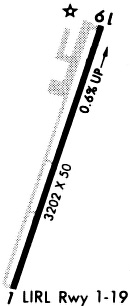
Runways
Runway Summary
| Runways: | 01/19 |
| Longest Runway: | 01/19 is 3215 ft (980 m) long |
| Runways with an Instrument Approach: |
F51 Airport Runway Details
| Runway 01/19 | 3215 ft x 50 ft (980 m x 15 m) | |
| Runway Length Source: | 3RD PARTY SURVEY as of 06/21/2022 | |
| Surface: | Asphalt - Good condition - No special surface treatment | |
| Runway Edge Lights: | Medium Intensity | |
Runway Weight Bearing Capacity (in thousands of pounds) |
||
| Single Wheel Landing Gear: | 12.0 | |
Runway 01 |
Runway 19 |
|
Elevation: |
493.0 | 513.3 |
Latitude: |
32-56-04.6476N | 32-56-34.9012N |
Longitude: |
095-16-49.7405W | 095-16-38.1046W |
|
Runway True Alignment: |
018 | 198 |
Glide Path Angle: |
0.0 degrees | 0.0 degrees |
Traffic Pattern: |
Right | Left |
Runway Markings Type: |
Nonprecision Instrument | Nonprecision Instrument |
Runway Markings Condition: |
Good | Good |
Object at End: |
TREES | TREES |
Object Height: |
14 | 60 |
Distance from End: |
289 | 880 |
Object Centerline Offset: |
0 ft. left and right of centerline | 0 ft. left and right of centerline |
Services
Bottled Oxygen: |
None |
Bulk Oxygen: |
None |
Fuel Available: |
100LL, Jet A |
Landing Fees: |
No |
Parking: |
Hangars and tiedowns available |
Maps & Diagrams
F51 Sectional
Flight Planning
at skyvector.com
at skyvector.com