Location
Latitude: |
38-53-22.0000N (38.889444) |
Longitude: |
079-51-25.7000W (-79.857139) |
Elevation: |
1987.2 feet MSL (606 m MSL) |
Magnetic Variation: |
9.1 W (as of April 2024 from WMM2020 model) |
Time Zone: |
UTC -5.0 (Standard Time) UTC -4.0 (Daylight Savings Time) |
From City: |
02 N.M. S of Elkins, West Virginia |
Found On: |
Cincinnati Chart |
FAA Region: |
AEA |
Contacts
Manager: |
Publicly owned: |
| MARY ALICE RICOTTILLI 400 AIRPORT RD ELKINS, WV 26241 304-636-2726 |
ELKINS-RANDOLPH CO RGNL ARPT AUTH 400 AIRPORT RD ELKINS, WV 26241 304-636-2726 |
Operations
Airport Status: |
Operational |
Facility Use: |
Public |
Type: |
Airport |
Activation Date: |
06/1938 |
Control tower: |
No |
Attendance (Months/Days/Hours): |
Months/Days/Hours ALL/ALL/0830-1700 |
Boundary ARTCC: |
ZDC (Washington) |
Responsible ARTCC: |
ZOB (Cleveland) |
Lighting Schedule: |
SEE RMK |
Segmented Circle Indicator: |
No |
Traffic Pattern Altitude (MSL): |
2987 feet (910 m) |
NOTAMs Facility: |
EKN |
NOTAM-D Service: |
Yes |
International Airport of Entry: |
No |
Customs Landing Rights: |
No |
Military Landing Rights: |
Yes |
Civil/Military Joint Use: |
No |
Based Aircraft
| Single Engine: | 23 |
| Multi Engine: | 4 |
| Jet Engine: | 1 |
Annual Operations (as of 12/31/2017)
| Total Operations: | 10500 | |
| GA Local: | 7000 | 66.7% |
| GA Itinerant: | 3000 | 28.6% |
| Military Aircraft: | 500 | 4.8% |
Communications
| CTAF: | 123.600 |
| Approach: | CLARKSBURG 121.15 121.15 WASHINGTON ARTCC |
| Departure: | CLARKSBURG 121.15 121.15 WASHINGTON ARTCC |
| ASOS: | 119.275 (304-636-5603) |
- APCH/DEP SVC PRVDD BY WASHINGTON ARTCC ON FREQS 128.6/226.675 (ELKINS RCAG) WHEN CLARKSBURG APCH CTL CLSD.
Fixed Based Operators (FBOs) & Fuel
(Click on a business for detail)
Please help us keep this information up to date. This is a FREE SERVICE just like everything else on Airport Guide! If you see that a business needs to be added, modified, or deleted please fill out our Update Form.
To add, modify, or delete a business click here.
Please help us keep this information up to date. This is a FREE SERVICE just like everything else on Airport Guide! If you see that a business needs to be added, modified, or deleted please fill out our Update Form.
Area Code: 304 |
| Business Name | Frequency | Phone | Fuel Grade |
|---|
Flight Service Stations
| Primary | Alternate | |
| FSS on Field: | N | |
| FSS Name (ID): | Elkins(EKN) | |
| Frequency: | ||
| Toll Free Phone: | 1-800-WX-BRIEF |
Instrument Procedures / Charts
FAA Terminal Procedures valid from 0901Z 03/21/24 to 0901Z 04/18/24.
There are various types of charts available for an airport. They are listed in the Page Type column. Here is a legend for those types:
APD - Airport Diagram
DP - Departure Procedure Charts
HOT - Hot Spots
IAP - Instrument Approach Procedure Charts
MIN - Minimums
STAR - Standard Terminal Arrival Charts
| Page Type | Page Name | Volume | Action Since Last Cycle |
|---|---|---|---|
| IAP | LDA-C | NE-4 | Changed |
| IAP | RNAV (GPS) RWY 05 | NE-4 | Changed |
| IAP | RNAV (GPS) RWY 23 | NE-4 | Changed |
| IAP | RNAV (GPS)-A | NE-4 | Changed |
| MIN | ALTERNATE MINIMUMS | NE-4 | |
| MIN | TAKEOFF MINIMUMS | NE-4 | |
| ODP | ELKINS ONE (OBSTACLE) | NE-4 |
Terminal Procedures are only available for airports in several countries with more being added all the time. If you are looking for a specific country's charts, please send an email to support(at)airportguide.com stating the country name. This will be used to prioritize the implementation.
Navigation Aids (Navaids) near EKN
| Dist (NM) | ID | Morse Code | Name | Type | Freq | True Hdg | Mag Hdg |
|---|---|---|---|---|---|---|---|
| 0.3 | RQY | . _ . _ _ . _ _ . _ _ | Randolph County | NDB | 284 | 338 | 347 |
| 11.4 | EKN | . _ . _ _ . | Elkins | VORTAC | 114.20 | 277 | 286 |
| 29.0 | CKB | _ . _ . _ . _ _ . . . | Clarksburg | VOR-DME | 112.60 | 318 | 327 |
| 40.0 | MGW | _ _ _ _ . . _ _ | Morgantown | VOR-DME | 111.60 | 359 | 368 |
| 45.2 | ESL | . . . . . _ . . | Kessel | VOR-DME | 110.80 | 63 | 72 |
| 58.4 | GRV | _ _ . . _ . . . . _ | Grantsville | DME | 112.3 | 39 | 48 |
| 59.0 | SH | . . . . . . . | Staut | NDB | 375 | 134 | 143 |
| 59.8 | VV | . . . _ . . . _ | Camor | NDB | 299 | 4 | 13 |
| 65.8 | LUA | . _ . . . . _ . _ | Caverns | NDB | 245 | 99 | 109 |
| 66.5 | LWB | . _ . . . _ _ _ . . . | Greenbrier | DME | 116.05 | 202 | 211 |
| 68.8 | CBE | _ . _ . _ . . . . | Cumberland | NDB | 317 | 48 | 58 |
| 69.0 | MOL | _ _ _ _ _ . _ . . | Montebello | VOR-DME | 115.30 | 149 | 158 |
| 69.1 | IHD | . . . . . . _ . . | Indian Head | TACAN | 108.20 | 19 | 28 |
| 70.7 | RNL | . _ . _ . . _ . . | Rainelle | VOR | 116.60 | 219 | 228 |
| 72.4 | LW | . _ . . . _ _ | Bushi | NDB | 346 | 203 | 212 |
| 77.2 | LDN | . _ . . _ . . _ . | Linden | VORTAC | 114.30 | 91 | 101 |
| 78.0 | JPU | . _ _ _ . _ _ . . . _ | Parkersburg | VOR-DME | 114.45 | 295 | 304 |
| 78.3 | PKB | . _ _ . _ . _ _ . . . | Marietta Ohio | FAN MARKER | 292 | 301 | |
| 78.9 | PK | . _ _ . _ . _ | Versi | NDB | 388 | 286 | 295 |
| 81.0 | AIR | . _ . . . _ . | Bellaire | VOR-DME | 117.10 | 326 | 335 |
Nearby Airports with Fuel
Notices to Airmen (NOTAMS)
Remarks
| A110-1 | UNCONTROLLED VEHICLES CROSSING RWY 32 THR. |
| A110-10 | RWY 32 156 FT TREES, 110 FM RWY END, 220 L. |
| A110-11 | FOR CD IF UNA TO CTC ON FSS FREQ, CTC WASHINGTON ARTCC AT 703-771-3587. |
| A110-4 | DEER ON & INVOF ARPT. |
| A110-5 | RWY 05/23 & 14/32 2-12 INCH DEEP DRAINAGE STRUCTURES ON PAVED SHOULDERS. |
| A110-6 | RWY 32, 100 FT AGL TWR, 500 FT SW. TOWER 100 FT AGL 500 FT SW RWY 32. |
| A110-7 | FOR AFTR HRS SERV. CALL AMGR DURING BUS. HRS. |
| A110-8 | COLD TEMPERATURE AIRPORT. ALTITUDE CORRECTION REQUIRED AT OR BELOW -20C. |
| A110-9 | RWY 23, 68 FT ATHLETIC FIELD LGTS, 550 FT S OF RWY CL. |
| A30-00X | THIS RUNWAY EXISTS TO SUPPORT THE OUW LDA/DME ASSOCIATED WITH THIS AIRPORT. |
| A43-23 | PAPI NON-STD 5 DEG GA. |
| A48-23 | OMNI-DIRECTIONAL REIL. |
| A57-05 | 86 FT ANTENNA, 850 FM RWY END APCH SLOPE 11:1 TO DSPLCD THR. |
| A57-32 | APCH SLOPE 9:1 AT DSPLCD THR OVR 156 FT TREE, 1500 FT DSTC, 220 FT L. |
| A58-05 | 30 FT TREES, 170 FT DSTC. |
| A58-32 | 156 FT TREES, 110 FT DSTC, 220 FT L. |
| A70-FUEL-A | ALL FUELING 24HR SELF SERVICE. |
| A81-APT | ACTVT MIRL RWY 05/23 & REIL RWY 23 - 122.9. |
| E111 | PRVDD DALGT VFR ONLY. |
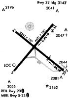
Runways
Runway Summary
| Runways: | 05/23 14/32 |
| Longest Runway: | 14/32 is 4544 ft (1385 m) long |
| Runways with an Instrument Approach: |
EKN Airport Runway Details
| Runway 05/23 | 4501 ft x 75 ft (1372 m x 23 m) | |
| Runway Length Source: | 3RD PARTY SURVEY as of 07/31/2014 | |
| Runway Edge Lights: | Medium Intensity | |
Runway Weight Bearing Capacity (in thousands of pounds) |
||
| Single Wheel Landing Gear: | 28.0 | |
| Dual Wheel Landing Gear: | 35.0 | |
| Dual Tandem Wheel Landing Gear: | 56.0 | |
Runway 05 |
Runway 23 |
|
Elevation: |
1973.5 | 1947.0 |
Latitude: |
38-53-05.9783N | 38-53-40.6520N |
Longitude: |
079-51-46.0006W | 079-51-10.3403W |
|
Runway True Alignment: |
039 | 219 |
Glide Path Angle: |
0.0 degrees | 5.0 degrees |
Traffic Pattern: |
Left | |
Runway Markings Type: |
Nonprecision Instrument | Nonprecision Instrument |
Runway Markings Condition: |
Fair | Fair |
Object at End: |
TREES | ANT |
Object Height: |
40 | 258 |
Object Marked/Lighted?: |
Lighted | |
Distance from End: |
201 | 2135 |
Visual Glide Slope Indicators: |
2-Light PAPI On Left Side Of Runway | |
REIL: |
No | Yes |
Threshold Crossing Height: |
45 | |
Threshold Elevation: |
1971.8 | |
Displaced Threshold: |
154 | |
Threshold Latitude: |
38-53-07.1634N | |
Threshold Longitude: |
079-51-44.7823W |
| Runway 14/32 | 4544 ft x 140 ft (1385 m x 43 m) | |
| Runway Length Source: | 3RD PARTY SURVEY as of 04/29/2010 | |
Runway Weight Bearing Capacity (in thousands of pounds) |
||
| Single Wheel Landing Gear: | 10.0 | |
Runway 14 |
Runway 32 |
|
Elevation: |
1940.0 | 1987.0 |
Latitude: |
38-53-34.8382N | 38-53-06.7043N |
Longitude: |
079-51-45.5332W | 079-51-00.7476W |
|
Runway True Alignment: |
129 | 309 |
Glide Path Angle: |
0.0 degrees | 0.0 degrees |
Traffic Pattern: |
Left | Left |
Runway Markings Type: |
Basic | Basic |
Runway Markings Condition: |
Fair | Fair |
Object at End: |
TREE | TREES |
Object Height: |
62 | 80 |
Distance from End: |
700 | 280 |
REIL: |
No | No |
Threshold Elevation: |
1969.7 | |
Displaced Threshold: |
1390 | |
Threshold Latitude: |
38-53-15.3113N | |
Threshold Longitude: |
079-51-14.4511W |
Services
Airframe Repair: |
Major |
Powerplant Repair: |
Major |
Bottled Oxygen: |
None |
Bulk Oxygen: |
None |
Fuel Available: |
100LL |
Landing Fees: |
No |
Parking: |
Hangars and tiedowns available |
Maps & Diagrams
EKN Sectional
Flight Planning
at skyvector.com
at skyvector.com