Location
Latitude: |
34-28-15.1440N (34.470873) |
Longitude: |
097-57-35.4970W (-97.95986) |
Elevation: |
1114.3 feet MSL (340 m MSL) |
Magnetic Variation: |
3.4 E (as of April 2024 from WMM2020 model) |
Time Zone: |
UTC -6.0 (Standard Time) UTC -5.0 (Daylight Savings Time) |
From City: |
02 N.M. S of Duncan, Oklahoma |
Found On: |
Dallas-Ft Worth Chart |
FAA Region: |
ASW |
Contacts
Manager: |
Publicly owned: |
| BUDDY HOKIT 2700 S 13TH ST, 1220 M. L. KING DUNCAN, OK 73533 580-470-2095 |
CITY OF DUNCAN 1600 S. HWY 81, 720 W. WILLOW DUNCAN, OK 73533 580-252-0250 |
Operations
Airport Status: |
Operational |
Facility Use: |
Public |
Type: |
Airport |
Activation Date: |
08/1938 |
Control tower: |
No |
Attendance (Months/Days/Hours): |
Months/Days/Hours ALL/ALL/0800-1700 |
Boundary ARTCC: |
ZFW (Fort Worth) |
Responsible ARTCC: |
ZFW (Fort Worth) |
Lighting Schedule: |
SEE RMK |
Segmented Circle Indicator: |
Yes |
Traffic Pattern Altitude (MSL): |
2114 feet (644 m) |
NOTAMs Facility: |
DUC |
NOTAM-D Service: |
Yes |
International Airport of Entry: |
No |
Customs Landing Rights: |
No |
Military Landing Rights: |
Yes |
Civil/Military Joint Use: |
No |
Based Aircraft
| Single Engine: | 27 |
| Multi Engine: | 7 |
| Jet Engine: | 3 |
| GA Helicopters: | 2 |
Annual Operations (as of 08/24/2023)
| Total Operations: | 8750 | |
| Air Taxi: | 250 | 2.9% |
| GA Local: | 6000 | 68.6% |
| GA Itinerant: | 2500 | 28.6% |
Communications
| CTAF: | 122.800 |
| Unicom: | 122.800 |
| Clearance Del.: | 118.4 118.4 118.4 |
| Approach: | FORT SILL |
| Departure: | FORT SILL |
| AWOS-3: | 119.075 (580-252-4547) |
Fixed Based Operators (FBOs) & Fuel
(Click on a business for detail)
Please help us keep this information up to date. This is a FREE SERVICE just like everything else on Airport Guide! If you see that a business needs to be added, modified, or deleted please fill out our Update Form.
To add, modify, or delete a business click here.
Please help us keep this information up to date. This is a FREE SERVICE just like everything else on Airport Guide! If you see that a business needs to be added, modified, or deleted please fill out our Update Form.
Area Code: 580 |
| Business Name | Frequency | Phone | Fuel Grade |
|---|---|---|---|
| Brewer Aviation
Update FBO info |
Unicom 122.8 | 252-9896 | 100LL, Jet A |
Flight Service Stations
| Primary | Alternate | |
| FSS on Field: | N | |
| FSS Name (ID): | Mc Alester(MLC) | |
| Frequency: | ||
| Toll Free Phone: | 1-800-WX-BRIEF |
Instrument Procedures / Charts
FAA Terminal Procedures valid from 0901Z 03/21/24 to 0901Z 04/18/24.
There are various types of charts available for an airport. They are listed in the Page Type column. Here is a legend for those types:
APD - Airport Diagram
DP - Departure Procedure Charts
HOT - Hot Spots
IAP - Instrument Approach Procedure Charts
MIN - Minimums
STAR - Standard Terminal Arrival Charts
| Page Type | Page Name | Volume | Action Since Last Cycle |
|---|---|---|---|
| IAP | RNAV (GPS) RWY 17 | SC-1 | |
| IAP | RNAV (GPS) RWY 35 | SC-1 | |
| MIN | TAKEOFF MINIMUMS | SC-1 |
Terminal Procedures are only available for airports in several countries with more being added all the time. If you are looking for a specific country's charts, please send an email to support(at)airportguide.com stating the country name. This will be used to prioritize the implementation.
Navigation Aids (Navaids) near DUC
| Dist (NM) | ID | Morse Code | Name | Type | Freq | True Hdg | Mag Hdg |
|---|---|---|---|---|---|---|---|
| 5.6 | DUC | _ . . . . _ _ . _ . | Duncan | DME | 111 | 157 | 154 |
| 22.5 | LAW | . _ . . . _ . _ _ | Lawton | VOR-DME | 116.85 | 274 | 270 |
| 23.5 | PFL | . _ _ . . . _ . . _ . . | Post | NDB | 425 | 290 | 286 |
| 28.7 | FSI | . . _ . . . . . . | Trail | FAN MARKER | 310 | 306 | |
| 28.7 | OFZ | _ _ _ . . _ . _ _ . . | Trail | NDB | 388 | 310 | 306 |
| 39.0 | PVJ | . _ _ . . . . _ . _ _ _ | Pauls Valley | NDB | 384 | 67 | 64 |
| 39.3 | SHP | . . . . . . . . _ _ . | Sheppard | TACAN | 110.80 | 221 | 217 |
| 41.6 | ICF | . . _ . _ . . . _ . | Madison | NDB | 296 | 216 | 212 |
| 42.2 | ADM | . _ _ . . _ _ | Ardmore | VORTAC | 116.70 | 111 | 108 |
| 42.8 | SPS | . . . . _ _ . . . . | Wichita Falls | VORTAC | 112.70 | 227 | 223 |
| 48.9 | SKB | . . . _ . _ _ . . . | Scotland | NDB | 344 | 212 | 208 |
| 49.1 | HMY | . . . . _ _ _ . _ _ | Muldrow | NDB | 512 | 46 | 43 |
| 52.5 | OUN | _ _ _ . . _ _ . | Norman | NDB | 370 | 27 | 24 |
| 52.7 | RG | . _ . _ _ . | Gally | NDB | 350 | 20 | 17 |
| 52.7 | GMZ | _ _ . _ _ _ _ . . | Grindstone Mountain | NDB | 356 | 169 | 166 |
| 52.8 | AI | . _ . . | Addmo | NDB | 400 | 105 | 102 |
| 56.0 | IRW | . . . _ . . _ _ | Will Rogers | VORTAC | 114.10 | 17 | 14 |
| 56.5 | UKW | . . _ _ . _ . _ _ | Bowie | VORTAC | 117.15 | 172 | 169 |
| 56.8 | OKC | _ _ _ _ . _ _ . _ . | Oklahoma Will Rgs W | VOT | 112.15 | 17 | 14 |
| 59.4 | HBR | . . . . _ . . . . _ . | Hobart | VORTAC | 111.80 | 293 | 289 |
Nearby Airports with Fuel
Notices to Airmen (NOTAMS)
Remarks
| A110-1 | FOR CD CTC FORT WORTH ARTCC AT 817-858-7584. |
| A14 | PUB WORKS DIR. |
| A16 | PHONE NR FOR PUB WORKS. ARPT TRML BLDG CTC 580-252-9896. |
| A17 | SECURITY PATROLS ARPT AFT HRS. |
| A70-FUEL-10 | 0LL FOR FUEL AFT HRS CALL 580-656-2020 OR 580-583-7196. |
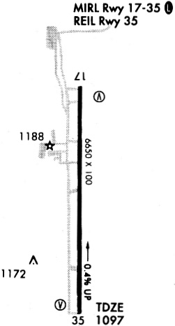
| A81-APT | ACTVT ODALS RWY 17 MED & HIGH INTST ONLY; REIL RWY 35; PAPI RWY 17; VASI RWY 35; MIRL RWY 17/35 - CTAF. |
Runways
Runway Summary
| Runways: | 17/35 |
| Longest Runway: | 17/35 is 6650 ft (2027 m) long |
| Runways with an Instrument Approach: | 35 |
DUC Airport Runway Details
| Runway 17/35 | 6650 ft x 100 ft (2027 m x 30 m) | |
| Runway Length Source: | FAA as of 02/28/2022 | |
| Surface: | Concrete - Good condition - No special surface treatment | |
| Runway Edge Lights: | Medium Intensity | |
Runway Weight Bearing Capacity (in thousands of pounds) |
||
| Single Wheel Landing Gear: | 44.0 | |
| Dual Wheel Landing Gear: | 56.0 | |
| Dual Dual Tandem Wheel Landing Gear: | 101.0 | |
Runway 17 |
Runway 35 |
|
Elevation: |
1114.3 | 1086.0 |
Latitude: |
34-28-48.0268N | 34-27-42.2620N |
Longitude: |
097-57-35.9834W | 097-57-35.0100W |
|
Runway True Alignment: |
179 | 359 |
ILS Type: |
LOCALIZER | |
Glide Path Angle: |
3.0 degrees | 3.0 degrees |
Traffic Pattern: |
Left | Left |
Runway Markings Type: |
Nonprecision Instrument | Nonprecision Instrument |
Runway Markings Condition: |
Good | Good |
Visual Glide Slope Indicators: |
4-Light PAPI On Right Side Of Runway | 4-Box VASI On Left Side Of Runway |
Approach Light System: |
Omnidirectional Approach Lighting System | |
REIL: |
No | Yes |
Threshold Crossing Height: |
53 | 42 |
Threshold Elevation: |
1087.4 | |
Displaced Threshold: |
325 | |
Threshold Latitude: |
34-27-45.4600N | |
Threshold Longitude: |
097-57-35.0600W | |
Declared Distances |
||
Take Off Run Avbl. (TORA): |
6325 | 6650 |
Take Off Distance Avbl. (TODA): |
6325 | 6650 |
Actual Stop Dist. Avbl. (ASDA): |
6325 | 6650 |
Landing Dist. Avbl. (LDA): |
6325 | 6325 |
Services
Airframe Repair: |
Major |
Powerplant Repair: |
Major |
Bulk Oxygen: |
High Pressure / Low Pressure |
Fuel Available: |
100LL, Jet A+ |
Landing Fees: |
Yes |
Parking: |
Hangars and tiedowns available |
Maps & Diagrams
DUC Sectional
Flight Planning
at skyvector.com
at skyvector.com