Location
Latitude: |
37-40-04.3820N (37.667884) |
Longitude: |
095-29-12.1760W (-95.486716) |
Elevation: |
1002.5 feet MSL (306 m MSL) |
Magnetic Variation: |
1.8 E (as of April 2024 from WMM2020 model) |
Time Zone: |
UTC -6.0 (Standard Time) UTC -5.0 (Daylight Savings Time) |
From City: |
02 N.M. SW of Chanute, Kansas |
Found On: |
Kansas City Chart |
FAA Region: |
ACE |
Contacts
Manager: |
Publicly owned: |
| RYAN FOLMER 800 S. COUNTRY CLUB ROAD CHANUTE, KS 66720 620-305-9689 |
CITY OF CHANUTE MEMORIAL BLDG CHANUTE, KS 66720 620-431-5296 |
Operations
Airport Status: |
Operational |
Facility Use: |
Public |
Type: |
Airport |
Activation Date: |
04/1940 |
Control tower: |
No |
Attendance (Months/Days/Hours): |
Months/Days/Hours ALL/MON-SAT/0800-1700 |
Boundary ARTCC: |
ZKC (Kansas City) |
Responsible ARTCC: |
ZKC (Kansas City) |
Lighting Schedule: |
SEE RMK |
Segmented Circle Indicator: |
Yes |
Traffic Pattern Altitude (MSL): |
2002 feet (610 m) |
NOTAMs Facility: |
CNU |
NOTAM-D Service: |
Yes |
International Airport of Entry: |
No |
Customs Landing Rights: |
No |
Military Landing Rights: |
Yes |
Civil/Military Joint Use: |
No |
Based Aircraft
| Single Engine: | 12 |
| Multi Engine: | 3 |
| GA Helicopters: | 1 |
Annual Operations (as of 12/31/2016)
| Total Operations: | 1700 | |
| GA Local: | 1265 | 74.4% |
| GA Itinerant: | 425 | 25.0% |
| Military Aircraft: | 10 | 0.6% |
Communications
| CTAF: | 122.700 |
| Unicom: | 122.700 |
| ASOS: | 127.075 (620-431-6781) |
- APCH/DEP CTL SVC PRVDD BY KANSAS CITY ARTCC (ZKC) ON FREQS 132.9/279.5 (CHANUTE RCAG).
Fixed Based Operators (FBOs) & Fuel
(Click on a business for detail)
Please help us keep this information up to date. This is a FREE SERVICE just like everything else on Airport Guide! If you see that a business needs to be added, modified, or deleted please fill out our Update Form.
To add, modify, or delete a business click here.
Please help us keep this information up to date. This is a FREE SERVICE just like everything else on Airport Guide! If you see that a business needs to be added, modified, or deleted please fill out our Update Form.
Area Code: 620 |
| Business Name | Frequency | Phone | Fuel Grade |
|---|
Flight Service Stations
| Primary | Alternate | |
| FSS on Field: | N | |
| FSS Name (ID): | Wichita(ICT) | |
| Frequency: | ||
| Toll Free Phone: | 1-800-WX-BRIEF |
Instrument Procedures / Charts
FAA Terminal Procedures valid from 0901Z 03/21/24 to 0901Z 04/18/24.
There are various types of charts available for an airport. They are listed in the Page Type column. Here is a legend for those types:
APD - Airport Diagram
DP - Departure Procedure Charts
HOT - Hot Spots
IAP - Instrument Approach Procedure Charts
MIN - Minimums
STAR - Standard Terminal Arrival Charts
| Page Type | Page Name | Volume | Action Since Last Cycle |
|---|---|---|---|
| IAP | RNAV (GPS) RWY 36 | NC-2 | Changed |
| IAP | VOR-A | NC-2 | Changed |
| MIN | ALTERNATE MINIMUMS | NC-2 | |
| MIN | TAKEOFF MINIMUMS | NC-2 |
Terminal Procedures are only available for airports in several countries with more being added all the time. If you are looking for a specific country's charts, please send an email to support(at)airportguide.com stating the country name. This will be used to prioritize the implementation.
Navigation Aids (Navaids) near CNU
| Dist (NM) | ID | Morse Code | Name | Type | Freq | True Hdg | Mag Hdg |
|---|---|---|---|---|---|---|---|
| 5.7 | CNU | _ . _ . _ . . . _ | Chanute | VOR-DME | 109.20 | 243 | 241 |
| 8.2 | MSB | _ _ . . . _ . . . | Monarch | NDB | 410 | 24 | 22 |
| 33.5 | OSW | _ _ _ . . . . _ _ | Oswego | DME | 117.6 | 156 | 154 |
| 34.7 | CFV | _ . _ . . . _ . . . . _ | Coffeyville | NDB | 212 | 186 | 184 |
| 35.1 | FSK | . . _ . . . . _ . _ | Fort Scott | NDB | 379 | 77 | 75 |
| 38.6 | PTS | . _ _ . _ . . . | Pittsburg | NDB | 365 | 110 | 108 |
| 39.5 | UKL | . . _ _ . _ . _ . . | Boyd | NDB | 245 | 343 | 341 |
| 48.4 | EMP | . _ _ . _ _ . | Emporia | VORTAC | 112.80 | 320 | 318 |
| 52.3 | JL | . _ _ _ . _ . . | Lunns | NDB | 344 | 121 | 120 |
| 55.7 | BV | _ . . . . . . _ | Dewie | NDB | 201 | 207 | 205 |
| 56.1 | BVO | _ . . . . . . _ _ _ _ | Bartlesville | VOR-DME | 117.90 | 207 | 205 |
| 57.0 | LLU | . _ . . . _ . . . . _ | Spring River | NDB | 356 | 100 | 99 |
| 59.5 | BUM | _ . . . . . _ _ _ | Butler | VORTAC | 115.90 | 52 | 51 |
| 70.5 | EOS | . _ _ _ . . . | Neosho | DME | 117.3 | 134 | 133 |
| 73.2 | FO | . . _ . _ _ _ | Riply | NDB | 326 | 356 | 354 |
| 74.1 | PK | . _ _ . _ . _ | Herbb | NDB | 420 | 28 | 26 |
| 76.4 | JZ | . _ _ _ _ _ . . | Newbn | NDB | 338 | 11 | 9 |
| 77.2 | FOE | . . _ . _ _ _ . | Forbes | TACAN | 111.60 | 353 | 351 |
| 77.5 | FOE | . . _ . _ _ _ . | Forbes | VOT | 111.00 | 353 | 351 |
| 78.7 | OJC | _ _ _ . _ _ _ _ . _ . | Johnson County | VOR-DME | 113.00 | 26 | 24 |
Nearby Airports with Fuel
Notices to Airmen (NOTAMS)
Remarks
| A110-1 | ULTRALIGHT ACTV, BIRDS & WILDLIFE ON & INVOF ARPT. |
| A110-3 | COURTSEY CAR AVBL. |
| A110-4 | FOR CD IF UNA TO CTC ON FSS FREQ, CTC KANSAS CITY ARTCC AT 913-254-8508. |
| A17 | FOR AFT HRS EMERG CALL (620) 305-9689. |
| A57-36 | APCH RATIO 32:1 FROM DSPLCD THR. |
| A58-18 | +25 FT TREE 173 FRM AER 18, 190 FT L OF CL. |
| A81-APT | ACTVT REIL RWY 18 & 36; PAPI RWY 18 & 36; MIRL RWY 18/36 - CTAF. |
| A81-BCN | DUSK-2300 |
| E111 | PRVDD CLEAR 20:1 APCH & 7:1 TRANSITIONAL SFC. |
Runways
Runway Summary
| Runways: | 18/36 |
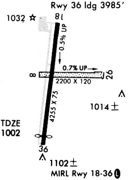
| Longest Runway: | 18/36 is 4254 ft (1297 m) long |
| Runways with an Instrument Approach: |
CNU Airport Runway Details
| Runway 18/36 | 4254 ft x 75 ft (1297 m x 23 m) | |
| Runway Length Source: | 3RD PARTY SURVEY as of 08/31/2022 | |
| Surface: | Asphalt - Good condition - No special surface treatment | |
| Runway Pavement Class: | 5 /F/C/Y/U | |
| Runway Edge Lights: | Medium Intensity | |
Runway Weight Bearing Capacity (in thousands of pounds) |
||
| Single Wheel Landing Gear: | 12.0 | |
Runway 18 |
Runway 36 |
|
Elevation: |
982.1 | 1001.3 |
Latitude: |
37-40-25.2674N | 37-39-43.4965N |
Longitude: |
095-29-09.1195W | 095-29-15.2317W |
|
Runway True Alignment: |
187 | 007 |
Glide Path Angle: |
3.0 degrees | 3.0 degrees |
Traffic Pattern: |
Left | Left |
Runway Markings Type: |
Nonprecision Instrument | Nonprecision Instrument |
Runway Markings Condition: |
Fair | Fair |
Object at End: |
TREE | RR |
Object Height: |
48 | 23 |
Distance from End: |
693 | 270 |
Object Centerline Offset: |
190 ft. left of centerline | 0 ft. left and right of centerline |
Visual Glide Slope Indicators: |
2-Light PAPI On Left Side Of Runway | 2-Light PAPI On Left Side Of Runway |
REIL: |
Yes | Yes |
Touchdown Lights: |
No | No |
Centerline Lights: |
No | No |
Threshold Crossing Height: |
40 | 40 |
Threshold Elevation: |
1001.3 | |
Displaced Threshold: |
269 | |
Threshold Latitude: |
37-39-46.1383N | |
Threshold Longitude: |
095-29-14.8452W |
Services
Fuel Available: |
100LL |
Landing Fees: |
No |
Parking: |
Tiedowns available |
Maps & Diagrams
CNU Sectional
Flight Planning
at skyvector.com
at skyvector.com