Location
Latitude: |
39-36-55.1010N (39.615306) |
Longitude: |
078-45-41.3220W (-78.761478) |
Elevation: |
775.0 feet MSL (236 m MSL) |
Magnetic Variation: |
9.9 W (as of April 2024 from WMM2020 model) |
Time Zone: |
UTC -5.0 (Standard Time) UTC -4.0 (Daylight Savings Time) |
From City: |
02 N.M. S of Cumberland, Maryland |
Found On: |
Washington Chart |
FAA Region: |
AEA |
Contacts
Manager: |
Publicly owned: |
| RYAN SHAFFER 165 TERMINAL LOOP WILEY FORD, WV 26767 304-738-0002 |
POTOMAC HIGHLAND ARPT AUTH 165 TERMINAL LOOP WILEY FORD, WV 26767 304-738-0002 |
Operations
Airport Status: |
Operational |
Facility Use: |
Public |
Type: |
Airport |
Activation Date: |
03/1944 |
Control tower: |
No |
Attendance (Months/Days/Hours): |
Months/Days/Hours ALL/ALL/0800-2000 |
Boundary ARTCC: |
ZOB (Cleveland) |
Responsible ARTCC: |
ZOB (Cleveland) |
Lighting Schedule: |
SEE RMK |
Segmented Circle Indicator: |
Yes |
Traffic Pattern Altitude (MSL): |
1775 feet (541 m) |
NOTAMs Facility: |
EKN |
NOTAM-D Service: |
Yes |
International Airport of Entry: |
No |
Customs Landing Rights: |
No |
Military Landing Rights: |
Yes |
Civil/Military Joint Use: |
No |
Based Aircraft
| Single Engine: | 44 |
| Multi Engine: | 2 |
| Jet Engine: | 1 |
| GA Helicopters: | 3 |
| Gliders: | 5 |
Annual Operations (as of 07/13/2023)
| Total Operations: | 14300 | |
| GA Local: | 11500 | 80.4% |
| GA Itinerant: | 2500 | 17.5% |
| Military Aircraft: | 300 | 2.1% |
Communications
| CTAF: | 122.800 |
| Unicom: | 122.800 |
| Approach: | JOHNSTOWN 121.2 121.2 CLEVELAND ARTCC |
| Departure: | JOHNSTOWN 121.2 121.2 CLEVELAND ARTCC |
| AWOS-3: | 128.625 (304-738-0451) |
- APCH/DEP SVC PRVDD BY CLEVELAND ARTCC (ZOB) ON FREQS 124.4/327.1 (ALTOONA RCAG) WHEN JOHNSTOWN APCH CTL CLSD.
Fixed Based Operators (FBOs) & Fuel
(Click on a business for detail)
Please help us keep this information up to date. This is a FREE SERVICE just like everything else on Airport Guide! If you see that a business needs to be added, modified, or deleted please fill out our Update Form.
To add, modify, or delete a business click here.
Please help us keep this information up to date. This is a FREE SERVICE just like everything else on Airport Guide! If you see that a business needs to be added, modified, or deleted please fill out our Update Form.
Area Code: 304 |
| Business Name | Frequency | Phone | Fuel Grade |
|---|---|---|---|
| Cumberland Air
Update FBO info |
Unicom 122.8 | 738-9671, 738-9603 | |
| Summerfield Aviation
Website Update FBO info |
738-2252, 800-839-2107 |
Flight Service Stations
| Primary | Alternate | |
| FSS on Field: | N | |
| FSS Name (ID): | Elkins(EKN) | |
| Frequency: | ||
| Toll Free Phone: | 1-800-WX-BRIEF |
Instrument Procedures / Charts
FAA Terminal Procedures valid from 0901Z 03/21/24 to 0901Z 04/18/24.
There are various types of charts available for an airport. They are listed in the Page Type column. Here is a legend for those types:
APD - Airport Diagram
DP - Departure Procedure Charts
HOT - Hot Spots
IAP - Instrument Approach Procedure Charts
MIN - Minimums
STAR - Standard Terminal Arrival Charts
| Page Type | Page Name | Volume | Action Since Last Cycle |
|---|---|---|---|
| IAP | LOC/DME RWY 23 | NE-3 | |
| IAP | RNAV (GPS) RWY 05 | NE-3 | |
| IAP | RNAV (GPS) RWY 23 | NE-3 | |
| MIN | ALTERNATE MINIMUMS | NE-3 | |
| MIN | TAKEOFF MINIMUMS | NE-3 |
Terminal Procedures are only available for airports in several countries with more being added all the time. If you are looking for a specific country's charts, please send an email to support(at)airportguide.com stating the country name. This will be used to prioritize the implementation.
Navigation Aids (Navaids) near CBE
| Dist (NM) | ID | Morse Code | Name | Type | Freq | True Hdg | Mag Hdg |
|---|---|---|---|---|---|---|---|
| 2.1 | CBE | _ . _ . _ . . . . | Cumberland | NDB | 317 | 18 | 28 |
| 13.4 | GRV | _ _ . . _ . . . . _ | Grantsville | DME | 112.3 | 275 | 285 |
| 25.7 | ESL | . . . . . _ . . | Kessel | VOR-DME | 110.80 | 204 | 214 |
| 29.1 | SYS | . . . _ . _ _ . . . | Stoystown | NDB | 209 | 345 | 355 |
| 34.9 | IHD | . . . . . . _ . . | Indian Head | TACAN | 108.20 | 308 | 318 |
| 42.0 | THS | _ . . . . . . . | St Thomas | VORTAC | 115.00 | 62 | 72 |
| 42.1 | HGR | . . . . _ _ . . _ . | Hagerstown | VOR | 109.80 | 82 | 92 |
| 42.2 | JST | . _ _ _ . . . _ | Johnstown | VOR-DME | 113.00 | 355 | 365 |
| 44.5 | MRB | _ _ . _ . _ . . . | Martinsburg | VORTAC | 112.10 | 107 | 117 |
| 47.5 | AOO | . _ _ _ _ _ _ _ | Altoona | VOR | 108.80 | 26 | 36 |
| 48.1 | VV | . . . _ . . . _ | Camor | NDB | 299 | 289 | 299 |
| 50.9 | MGW | _ _ _ _ . . _ _ | Morgantown | VOR-DME | 111.60 | 266 | 276 |
| 51.3 | BHU | _ . . . . . . . . . _ | Benje | NDB | 382 | 332 | 342 |
| 52.5 | LDN | . _ . . _ . . _ . | Linden | VORTAC | 114.30 | 150 | 160 |
| 55.9 | REC | . _ . . _ . _ . | Revloc | VOR-DME | 110.60 | 0 | 10 |
| 56.6 | LUA | . _ . . . . _ . _ | Caverns | NDB | 245 | 166 | 176 |
| 58.7 | GDX | _ _ . _ . . _ . . _ | Goodwin Lake | NDB | 227 | 132 | 142 |
| 62.6 | INP | . . _ . . _ _ . | Indiana | NDB | 242 | 347 | 357 |
| 64.6 | MKP | _ _ _ . _ . _ _ . | Mc Keesport | NDB | 287 | 313 | 323 |
| 65.3 | FDK | . . _ . _ . . _ . _ | Frederick | VOR | 109.00 | 100 | 110 |
Nearby Airports with Fuel
Notices to Airmen (NOTAMS)
Remarks
| A110-1 | RWY 11 NGT OPNS & ANY LNDGS NOT RECOMMENDED DUE TO HIGH TERRAIN. |
| A110-2 | GLIDER OPNS W OF ARPT USE RWY 11 FOR DEP; RWY 29 FOR ARR. |
| A110-3 | DEER/BIRDS ON & INVOF ARPT. |
| A110-4 | RWY 23 900 FT TWY ALIGNED WITH RWY WEST END. |
| A110-6 | RWY 05 APCH HAS RAPIDLY RISING TERRAIN 696 FT L, 2000 FT FM THR. |
| A110-8 | FOR CD CTC JOHNSTOWN APCH AT 814-532-5960, WHEN APCH CLSD CTC CLEVELAND ARTCC AT 440-774-0213. |
| A110-9 | COLD TEMPERATURE AIRPORT. ALTITUDE CORRECTION REQUIRED AT OR BELOW -15C. |
| A40-11/29 | NSTD LIRL FM RWY 11 THR TO RWY 11 DSPLCD THR, DUE TO IMPROPER LENS COLORS AND SPACING. |
| A42-05 | FADED |
| A42-05 1 | RWY 05/23 MARKINGS & CL PARTIALLY OBSCURED BY LONGITUDINAL AND TRANSVERSE CRACK FILL. RWY 05/23 MARKINGS FADED. |
| A42-23 | FADED |
| A42-29 | FADED |
| A5 | COUNTY LOCATED IN WV. |
| A73 | BOTTLE OXY AVBL FM 0800-1500 MON-FRI BY PRIOR ARNGMT - CALL 304-738-0002 EXT 11. |
| A74 | BULK OXY AVBL FM 0800-1500 MON-FRI BY PRIOR ARNGMT - CALL 304-738-0002 EXT 11. |
| A80 | ROTG BCN LOCATED OFF ARPT. |
| A81-APT | ACTVT REIL RWY 23; HIRL RWY 05/23; LIRL RWY 11/29; & TWY LGTS - CTAF. |
| E111 | ESTAB PRIOR 1959. |
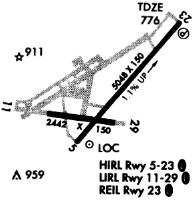
Runways
Runway Summary
| Runways: | 05/23 11/29 |
| Longest Runway: | 05/23 is 5047 ft (1538 m) long |
| Runways with an Instrument Approach: | 23 |
CBE Airport Runway Details
| Runway 05/23 | 5047 ft x 150 ft (1538 m x 46 m) | |
| Runway Length Source: | 3RD PARTY SURVEY as of 10/05/2016 | |
| Surface: | Asphalt - Fair condition - No special surface treatment | |
| Runway Edge Lights: | High Intensity | |
Runway Weight Bearing Capacity (in thousands of pounds) |
||
| Single Wheel Landing Gear: | 38.0 | |
| Dual Wheel Landing Gear: | 52.0 | |
Runway 05 |
Runway 23 |
|
Elevation: |
721.9 | 775.0 |
Latitude: |
39-36-39.8492N | 39-37-18.5769N |
Longitude: |
078-45-53.1330W | 078-45-12.4941W |
|
Runway True Alignment: |
039 | 219 |
ILS Type: |
LOC/DME | |
Glide Path Angle: |
0.0 degrees | 3.6 degrees |
Traffic Pattern: |
Right | Left |
Runway Markings Type: |
Nonprecision Instrument | Precision Instrument |
Runway Markings Condition: |
Poor | Poor |
Object at End: |
TREES | |
Object Height: |
6 | |
Distance from End: |
310 | |
Object Centerline Offset: |
0 ft. left and right of centerline | |
Visual Glide Slope Indicators: |
4-Light PAPI On Left Side Of Runway | |
REIL: |
Yes | |
Threshold Crossing Height: |
29 |
| Runway 11/29 | 3000 ft x 150 ft (914 m x 46 m) | |
| Runway Length Source: | 3RD PARTY SURVEY as of 10/05/2016 | |
| Surface: | Asphalt - Fair condition - No special surface treatment | |
| Runway Edge Lights: | Low Intensity | |
Runway Weight Bearing Capacity (in thousands of pounds) |
||
| Single Wheel Landing Gear: | 12.0 | |
Runway 11 |
Runway 29 |
|
Elevation: |
721.2 | 727.0 |
Latitude: |
39-36-49.9819N | 39-36-46.3827N |
Longitude: |
078-46-14.6566W | 078-45-36.6110W |
|
Runway True Alignment: |
097 | 277 |
Glide Path Angle: |
0.0 degrees | 0.0 degrees |
Traffic Pattern: |
Left | Left |
Runway Markings Type: |
Basic | Nonprecision Instrument |
Runway Markings Condition: |
Good | Poor |
Object at End: |
HILL | |
Object Height: |
336 | |
Distance from End: |
4187 | |
Object Centerline Offset: |
0 ft. left and right of centerline | |
Threshold Elevation: |
722.5 | |
Displaced Threshold: |
560 | |
Threshold Latitude: |
39-36-49.3096N | |
Threshold Longitude: |
078-46-07.5526W |
Services
Airframe Repair: |
Major |
Powerplant Repair: |
Major |
Bottled Oxygen: |
None |
Bulk Oxygen: |
None |
Fuel Available: |
100LL |
Landing Fees: |
No |
Parking: |
Tiedowns available |
Maps & Diagrams
CBE Sectional
Flight Planning
at skyvector.com
at skyvector.com