Location
Latitude: |
36-45-48.1000N (36.763361) |
Longitude: |
096-00-40.3000W (-96.011194) |
Elevation: |
716.9 feet MSL (219 m MSL) |
Magnetic Variation: |
2.2 E (as of April 2024 from WMM2020 model) |
Time Zone: |
UTC -6.0 (Standard Time) UTC -5.0 (Daylight Savings Time) |
From City: |
02 N.M. NW of Bartlesville, Oklahoma |
Found On: |
Kansas City Chart |
FAA Region: |
ASW |
Contacts
Manager: |
Publicly owned: |
| MIKE RICHARDSON 401 NW WILEY POST RD. BARTLESVILLE, OK 74003 (918) 661-3500 |
CITY OF BARTLESVILLE CITY HALL, 401 S. JOHNSTONE BARTLESVILLE, OK 74003 918-338-4282 |
Operations
Airport Status: |
Operational |
Facility Use: |
Public |
Type: |
Airport |
Activation Date: |
11/1938 |
Control tower: |
No |
Attendance (Months/Days/Hours): |
Months/Days/Hours ALL/MON-THU/0700-1900 |
Boundary ARTCC: |
ZKC (Kansas City) |
Responsible ARTCC: |
ZKC (Kansas City) |
Lighting Schedule: |
SEE RMK |
Segmented Circle Indicator: |
Yes |
Traffic Pattern Altitude (MSL): |
1717 feet (523 m) |
NOTAMs Facility: |
BVO |
NOTAM-D Service: |
Yes |
International Airport of Entry: |
No |
Customs Landing Rights: |
No |
Military Landing Rights: |
Yes |
Civil/Military Joint Use: |
No |
Based Aircraft
| Single Engine: | 41 |
| Multi Engine: | 4 |
| Jet Engine: | 2 |
Annual Operations (as of 03/17/2023)
| Total Operations: | 12362 | |
| GA Local: | 3090 | 25.0% |
| GA Itinerant: | 9272 | 75.0% |
Communications
| CTAF: | 122.825 |
| ASOS: | 132.675 (918-336-2070) |
- APCH/DEP CTL SVC PRVDD BY KANSAS CITY ARTCC (ZKC) ON FREQS 128.6/282.325 (EDNA RCAG).
- NOTE: THIS FACILITY IS NOT AN ATCT FACILITY BUT AN ADVISORY COMMUNICATIONS STATION OPERATED BY THE AIRPORT.
- ADZY FREQ 122.825 MONITORED M-F DURG BUS HRS.
Fixed Based Operators (FBOs) & Fuel
(Click on a business for detail)
Please help us keep this information up to date. This is a FREE SERVICE just like everything else on Airport Guide! If you see that a business needs to be added, modified, or deleted please fill out our Update Form.
To add, modify, or delete a business click here.
Please help us keep this information up to date. This is a FREE SERVICE just like everything else on Airport Guide! If you see that a business needs to be added, modified, or deleted please fill out our Update Form.
Area Code: 918 |
| Business Name | Frequency | Phone | Fuel Grade |
|---|---|---|---|
| Phillips Aviation Services
Update FBO info |
Unicom 123.0 | 661-3121 | 100LL, Jet A |
Flight Service Stations
| Primary | Alternate | |
| FSS on Field: | N | |
| FSS Name (ID): | Mc Alester(MLC) | |
| Frequency: | ||
| Toll Free Phone: | 1-800-WX-BRIEF |
Instrument Procedures / Charts
FAA Terminal Procedures valid from 0901Z 03/21/24 to 0901Z 04/18/24.
There are various types of charts available for an airport. They are listed in the Page Type column. Here is a legend for those types:
APD - Airport Diagram
DP - Departure Procedure Charts
HOT - Hot Spots
IAP - Instrument Approach Procedure Charts
MIN - Minimums
STAR - Standard Terminal Arrival Charts
| Page Type | Page Name | Volume | Action Since Last Cycle |
|---|---|---|---|
| IAP | LOC RWY 17 | SC-1 | |
| IAP | RNAV (GPS) RWY 17 | SC-1 | |
| IAP | RNAV (GPS) RWY 35 | SC-1 | |
| IAP | VOR/DME RWY 35 | SC-1 | |
| MIN | ALTERNATE MINIMUMS | SC-1 | |
| MIN | TAKEOFF MINIMUMS | SC-1 |
Terminal Procedures are only available for airports in several countries with more being added all the time. If you are looking for a specific country's charts, please send an email to support(at)airportguide.com stating the country name. This will be used to prioritize the implementation.
Navigation Aids (Navaids) near BVO
| Dist (NM) | ID | Morse Code | Name | Type | Freq | True Hdg | Mag Hdg |
|---|---|---|---|---|---|---|---|
| 4.3 | BVO | _ . . . . . . _ _ _ _ | Bartlesville | VOR-DME | 117.90 | 355 | 353 |
| 4.6 | BV | _ . . . . . . _ | Dewie | NDB | 201 | 358 | 356 |
| 28.9 | CFV | _ . _ . . . _ . . . . _ | Coffeyville | NDB | 212 | 46 | 44 |
| 34.4 | TUL | _ . . _ . _ . . | Tulsa Intl | VOT | 109.00 | 169 | 167 |
| 35.7 | TUL | _ . . _ . _ . . | Tulsa | VORTAC | 114.40 | 162 | 160 |
| 36.1 | OWP | _ _ _ . _ _ . _ _ . | William Pogue | NDB | 362 | 191 | 189 |
| 40.4 | TU | _ . . _ | Oillr | NDB | 338 | 171 | 169 |
| 45.4 | OSW | _ _ _ . . . . _ _ | Oswego | DME | 117.6 | 58 | 56 |
| 50.6 | GNP | _ _ . _ . . _ _ . | Glenpool | DME | 110.6 | 177 | 175 |
| 52.5 | PN | . _ _ . _ . | Ponca | NDB | 515 | 274 | 271 |
| 52.9 | SO | . . . _ _ _ | Sawcy | NDB | 353 | 292 | 289 |
| 55.2 | PER | . _ _ . . . _ . | Pioneer | VORTAC | 113.20 | 269 | 266 |
| 55.5 | CNU | _ . _ . _ . . . _ | Chanute | VOR-DME | 109.20 | 20 | 18 |
| 60.6 | OK | _ _ _ _ . _ | Preso | NDB | 388 | 177 | 175 |
| 60.8 | SW | . . . . _ _ | Gabeh | NDB | 255 | 238 | 235 |
| 60.9 | SWO | . . . . _ _ _ _ _ | Stillwater | VOR-DME | 108.40 | 238 | 235 |
| 64.0 | CUH | _ . _ . . . _ . . . . | Cushing | NDB | 242 | 215 | 213 |
| 64.6 | OKM | _ _ _ _ . _ _ _ | Okmulgee | VOR-DME | 114.90 | 173 | 171 |
| 67.9 | MSB | _ _ . . . _ . . . | Monarch | NDB | 410 | 24 | 22 |
| 69.8 | TQH | _ _ _ . _ . . . . | Tahlequah | NDB | 215 | 135 | 133 |
Nearby Airports with Fuel
Notices to Airmen (NOTAMS)
Remarks
| A110-2 | FOR CD IF UNA TO CTC ON FSS FREQ, CTC KANSAS CITY ARTCC AT 913-254-8508. |
| A16 | FOR EMERG ONLY 918-350-0076. |
| A81-APT | ACTVT MALSR RWY 17; REIL RWY 35; PAPI RWY 17 & 35 - CTAF. MIRL RWY 17/35 OPER SS TO SR & PRESET LOW INTST, INCR INTST - CTAF. |
| E100 | ADZY FREQ 122.825 MNT M-F DURG BUS HRS. |
Runways
Runway Summary
| Runways: | 17/35 |
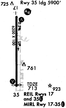
| Longest Runway: | 17/35 is 6850 ft (2088 m) long |
| Runways with an Instrument Approach: | 17 |
BVO Airport Runway Details
| Runway 17/35 | 6850 ft x 100 ft (2088 m x 30 m) | |
| Runway Length Source: | 3RD PARTY SURVEY as of 08/14/2011 | |
| Surface: | Concrete - Good condition - Saw-cut or plastic grooved | |
| Runway Edge Lights: | Medium Intensity | |
Runway Weight Bearing Capacity (in thousands of pounds) |
||
| Single Wheel Landing Gear: | 50.0 | |
| Dual Wheel Landing Gear: | 100.0 | |
| Dual Tandem Wheel Landing Gear: | 170.0 | |
Runway 17 |
Runway 35 |
|
Elevation: |
685.5 | 716.9 |
Latitude: |
36-46-21.9466N | 36-45-14.2272N |
Longitude: |
096-00-41.0885W | 096-00-39.4277W |
|
Runway True Alignment: |
179 | 359 |
ILS Type: |
LOCALIZER | |
Glide Path Angle: |
3.0 degrees | 3.0 degrees |
Traffic Pattern: |
Right | Left |
Runway Markings Type: |
Precision Instrument | Precision Instrument |
Runway Markings Condition: |
Good | Good |
Object at End: |
TREES | |
Object Height: |
31 | |
Distance from End: |
572 | |
Object Centerline Offset: |
344 ft. right of centerline | |
Visual Glide Slope Indicators: |
4-Light PAPI On Left Side Of Runway | 4-Light PAPI On Left Side Of Runway |
Approach Light System: |
1,400 Foot Medium Intensity Approach Lighting System With Runway Alignment Indicator Lights | |
REIL: |
Yes | |
Threshold Crossing Height: |
53 | 45 |
Threshold Elevation: |
711.9 | |
Displaced Threshold: |
649 | |
Threshold Latitude: |
36-45-20.6465N | |
Threshold Longitude: |
096-00-39.5833W | |
Declared Distances |
||
Take Off Run Avbl. (TORA): |
6201 | 6850 |
Take Off Distance Avbl. (TODA): |
6201 | 6850 |
Actual Stop Dist. Avbl. (ASDA): |
6201 | 6850 |
Landing Dist. Avbl. (LDA): |
6201 | 6201 |
Services
Airframe Repair: |
None |
Powerplant Repair: |
Major |
Bottled Oxygen: |
None |
Bulk Oxygen: |
None |
Fuel Available: |
100LL, Jet A+ |
Landing Fees: |
No |
Parking: |
Tiedowns available |
Maps & Diagrams
BVO Sectional
Flight Planning
at skyvector.com
at skyvector.com