
Location
Latitude: |
54-39-27.0044N (54.657501) |
Longitude: |
006-12-56.9875W (-6.21583) |
Elevation: |
268 feet MSL (82 m MSL) |
Magnetic Variation: |
1.8 W (as of April 2024 from WMM2020 model) |
Time Zone: |
UTC +0.0 (Standard Time) UTC +1.0 (Daylight Savings Time) |
Contacts
Manager: |
: |
Operations
Airport Status: |
Operational |
Facility Use: |
Public |
Type: |
Airport |
Traffic Pattern Altitude (MSL): |
1268 feet (386 m) |
Based Aircraft
Annual Operations (as of )
Communications
| TWR: | 118.3 |
| GND: | 121.75 |
| APP: | 128.5 |
| ATIS: | 128.2 |
| ILS 17: | 110.9 |
| ILS 25: | 109.9 |
| OPS: | 26.48 |
| DIRECTOR: | 120.9 |
Fixed Based Operators (FBOs) & Fuel
(Click on a business for detail)
Please help us keep this information up to date. This is a FREE SERVICE just like everything else on Airport Guide! If you see that a business needs to be added, modified, or deleted please fill out our Update Form.
To add, modify, or delete a business click here.
Please help us keep this information up to date. This is a FREE SERVICE just like everything else on Airport Guide! If you see that a business needs to be added, modified, or deleted please fill out our Update Form.
| Business Name | Frequency | Phone | Fuel Grade |
|---|---|---|---|
| Global Trek Aviation
Website Update FBO info |
131.91 | +44 (0) 289 445 4546 | Jet A-1 |
| Woodgate Aviation
Website Update FBO info |
+44 28 9442 2478 | Jet A-1, Avgas 100LL |
Flight Service Stations
| Primary | Alternate | |
| FSS on Field: | ||
| FSS Name (ID): | ||
| Frequency: | ||
| Toll Free Phone: |
Instrument Procedures / Charts
Terminal Procedures are only available for airports in several countries with more being added all the time. If you are looking for a specific country's charts, please send an email to support(at)airportguide.com stating the country name. This will be used to prioritize the implementation.
Navigation Aids (Navaids) near BFS
| Dist (NM) | ID | Morse Code | Name | Type | Freq | True Hdg | Mag Hdg |
|---|---|---|---|---|---|---|---|
| 0.5 | BEL | Belfast | VOR-DME | 117.20 | 293 | 295 | |
| 5.0 | OY | Aldergrove | NDB | 332 | 64 | 66 | |
| 36.7 | BKL | Ballykelly | TACAN | 109.15 | 311 | 313 | |
| 50.1 | CBL | Campbeltown | NDB | 380 | 21 | 23 | |
| 50.3 | MAC | Machrihanish | VOR-DME | 116.00 | 22 | 24 | |
| 52.2 | EKN | Enniskillen | NDB | 358 | 252 | 254 | |
| 52.4 | EKN | Enniskillen | DME | 116.75 | 253 | 255 | |
| 60.6 | GMN | Gormanston | NDB-DME | 334 | 180 | 182 | |
| 61.5 | LAY | Islay | NDB | 395 | 358 | 360 | |
| 61.5 | ISY | Islay | DME | 109.95 | 358 | 360 | |
| 61.9 | IOM | Isle Of Man | VOR-DME | 112.20 | 124 | 125 | |
| 63.1 | TRN | Turnberry | VOR-DME | 117.50 | 50 | 52 | |
| 65.5 | RWY | Isle Of Man | NDB | 359 | 121 | 122 | |
| 67.7 | CAR | Carnane | NDB | 367 | 116 | 117 | |
| 68.2 | GAR | Garristown | NDB | 407 | 186 | 188 | |
| 68.8 | RSH | Rush | NDB | 326 | 176 | 178 | |
| 69.6 | DUB | Dublin | VOR-DME | 114.90 | 182 | 184 | |
| 74.0 | OE | Dublin | NDB | 316 | 185 | 187 | |
| 74.1 | DAP | Dublin | VOR-DME | 111.20 | 182 | 184 | |
| 74.3 | ID | Dublin | DME | 108.90 | 181 | 183 |
Nearby Airports with Fuel
| Dist (NM) | Name (Airport IDs) | True Hdg | Mag Hdg | Fuel Grade |
|---|---|---|---|---|
| 75.8 | Glasgow Prestwick Airport (PIK EGPK) |
46 | 47 | 100LL, Jet A-1 |
Notices to Airmen (NOTAMS)
Remarks
No remarks for this landing facility
Runways
Runway Summary
| Runways: | 07/25 17/35 |
| Longest Runway: | 07/25 is 9121 ft (2780 m) long |
| Runways with an Instrument Approach: |
BFS Airport Runway Details
| Runway 07/25 | 9121 ft x 148 ft (2780 m x 45 m) | |
| Runway Edge Lights: | Yes Intensity | |
Runway 07 |
Runway 25 |
|
Elevation: |
206 | 268 |
Latitude: |
54.65230178833 | 54.66279983520 |
Longitude: |
-6.235239982604 | -6.196179866790 |
|
Runway True Alignment: |
65 | 245 |
Glide Path Angle: |
0.0 degrees | 0.0 degrees |
REIL: |
Yes | Yes |
Threshold Elevation: |
206 | 268 |
| Runway 17/35 | 6204 ft x 148 ft (1891 m x 45 m) | |
| Runway Edge Lights: | Yes Intensity | |
Runway 17 |
Runway 35 |
|
Elevation: |
206 | 258 |
Latitude: |
54.65790176391 | 54.64260101318 |
Longitude: |
-6.228620052337 | -6.219989776611 |
|
Runway True Alignment: |
162 | 342 |
Glide Path Angle: |
0.0 degrees | 0.0 degrees |
REIL: |
Yes | Yes |
Threshold Elevation: |
206 | 258 |
Displaced Threshold: |
525 | 502 |
Services
Fuel Available: |
100LL, Jet A-1 |
Other Services: |
Nitrogen cart, Tugs, Maintenance platforms, Air Stairs, Power carts, First class VIP facility |
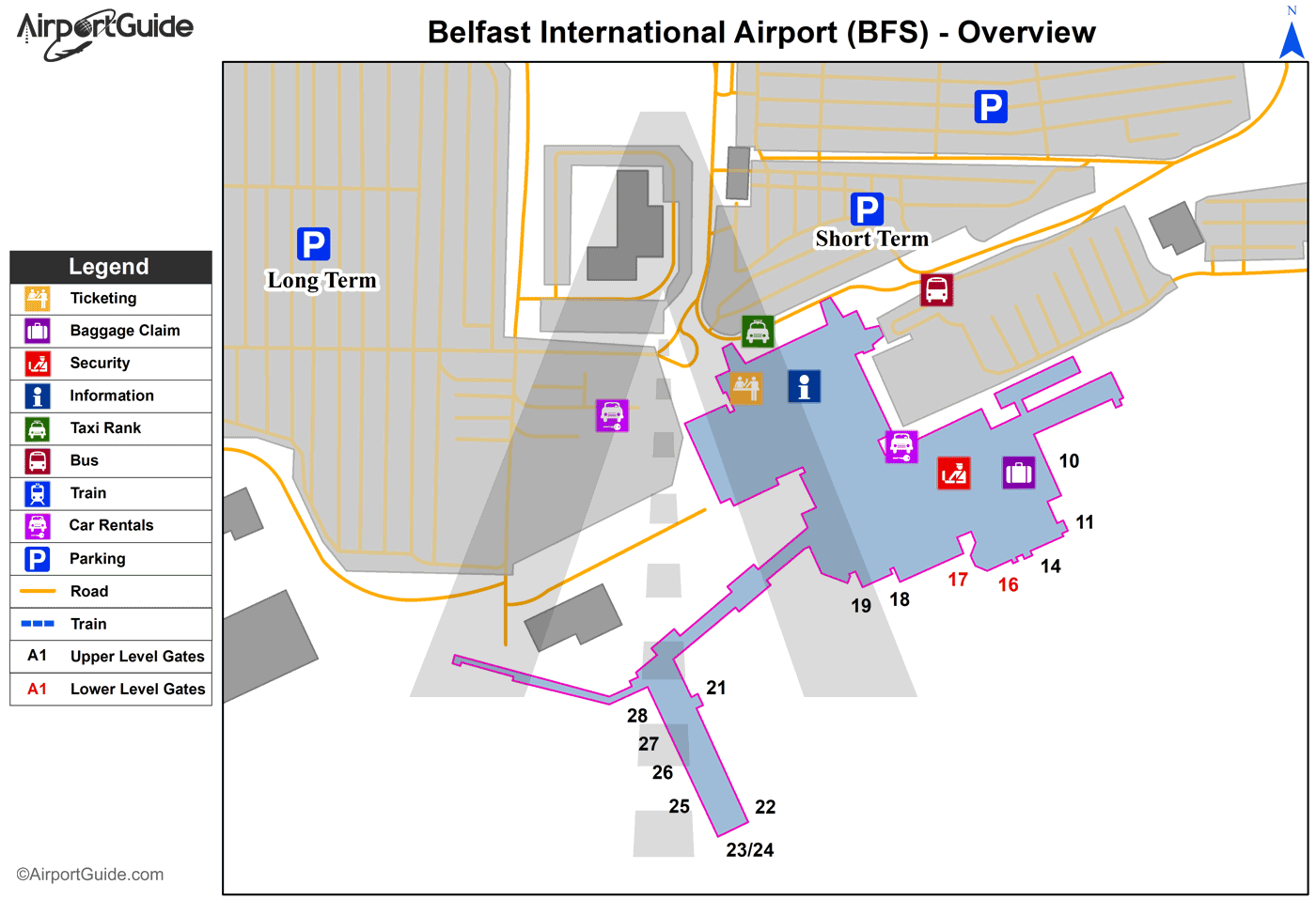
Maps & Diagrams
BFS Sectional
Flight Planning
at skyvector.com
at skyvector.com
