Location
Latitude: |
41-33-28.0000N (41.557778) |
Longitude: |
122-51-17.8000W (-122.854944) |
Elevation: |
2728.0 feet MSL (831 m MSL) |
Magnetic Variation: |
13.9 E (as of April 2024 from WMM2020 model) |
Time Zone: |
UTC -8.0 (Standard Time) UTC -7.0 (Daylight Savings Time) |
From City: |
03 N.M. S of Fort Jones, California |
Found On: |
Klamath Falls Chart |
FAA Region: |
AWP |
Contacts
Manager: |
Publicly owned: |
| ANGIE STUMBAUGH 190 GREENHORN ROAD YREKA, CA 96097 530-842-8297 |
COUNTY OF SISKIYOU 190 GREENHORN ROAD YREKA, CA 96097 (530) 842-8259 |
Operations
Airport Status: |
Operational |
Facility Use: |
Public |
Type: |
Airport |
Activation Date: |
12/1949 |
Control tower: |
No |
Attendance (Months/Days/Hours): |
Months/Days/Hours Unattended |
Boundary ARTCC: |
ZSE (Seattle) |
Responsible ARTCC: |
ZSE (Seattle) |
Lighting Schedule: |
SEE RMK |
Segmented Circle Indicator: |
Yes |
Traffic Pattern Altitude (MSL): |
3728 feet (1136 m) |
NOTAMs Facility: |
RIU |
NOTAM-D Service: |
Yes |
International Airport of Entry: |
No |
Customs Landing Rights: |
No |
Military Landing Rights: |
Yes |
Civil/Military Joint Use: |
No |
Based Aircraft
| Single Engine: | 17 |
| GA Helicopters: | 1 |
Annual Operations (as of 12/31/2022)
| Total Operations: | 8104 | |
| Air Taxi: | 104 | 1.3% |
| GA Local: | 3000 | 37.0% |
| GA Itinerant: | 5000 | 61.7% |
Communications
| CTAF: | 122.800 |
| Unicom: | 122.800 |
Fixed Based Operators (FBOs) & Fuel
(Click on a business for detail)
Please help us keep this information up to date. This is a FREE SERVICE just like everything else on Airport Guide! If you see that a business needs to be added, modified, or deleted please fill out our Update Form.
To add, modify, or delete a business click here.
Please help us keep this information up to date. This is a FREE SERVICE just like everything else on Airport Guide! If you see that a business needs to be added, modified, or deleted please fill out our Update Form.
Area Code: 530 |
| Business Name | Frequency | Phone | Fuel Grade |
|---|---|---|---|
| Scott Valley Pilots Association
Website Update FBO info |
530-598-5211 | 100LL | |

|
Unknown - 7.00 USD per gallon on 07/29/2023 |
24 Hour Self Serve Credit Card Pumps Self serve |
Flight Service Stations
| Primary | Alternate | |
| FSS on Field: | N | |
| FSS Name (ID): | Rancho Murieta(RIU) | |
| Frequency: | ||
| Toll Free Phone: | 1-800-WX-BRIEF |
Instrument Procedures / Charts
Terminal Procedures are only available for airports in several countries with more being added all the time. If you are looking for a specific country's charts, please send an email to support(at)airportguide.com stating the country name. This will be used to prioritize the implementation.
Navigation Aids (Navaids) near A30
| Dist (NM) | ID | Morse Code | Name | Type | Freq | True Hdg | Mag Hdg |
|---|---|---|---|---|---|---|---|
| 6.8 | FJS | . . _ . . _ _ _ . . . | Fort Jones | VOR-DME | 116.25 | 161 | 147 |
| 19.6 | MOG | _ _ _ _ _ _ _ . | Montague | NDB | 404 | 58 | 44 |
| 48.0 | MFR | _ _ . . _ . . _ . | Medford | VOT | 117.20 | 359 | 345 |
| 50.0 | MEF | _ _ . . . _ . | Medford | NDB | 356 | 358 | 344 |
| 55.4 | OED | _ _ _ . _ . . | Rogue Valley | VORTAC | 113.60 | 357 | 343 |
| 61.8 | LMT | . _ . . _ _ _ | Klamath Falls | VORTAC | 115.90 | 54 | 40 |
| 63.5 | CEC | _ . _ . . _ . _ . | Crescent City | VORTAC | 109.00 | 282 | 268 |
| 66.3 | ACV | . _ _ . _ . . . . _ | Arcata | VOR-DME | 115.05 | 238 | 224 |
| 68.1 | RDD | . _ . _ . . _ . . | Redding | VOR-DME | 114.35 | 157 | 143 |
| 82.0 | FOT | . . _ . _ _ _ _ | Fortuna | VORTAC | 114.00 | 229 | 215 |
| 91.1 | PBT | . _ _ . _ . . . _ | Proberta | NDB | 338 | 161 | 147 |
| 91.9 | RBL | . _ . _ . . . . _ . . | Red Bluff | VORTAC | 115.70 | 162 | 148 |
| 99.9 | RBG | . _ . _ . . . _ _ . | Roseburg | VOR-DME | 108.20 | 347 | 333 |
Nearby Airports with Fuel
Notices to Airmen (NOTAMS)
Remarks
| A110-2 | (E93) USFC HELIPORT. OPERATES FIRE SEASON ONLY. |
| A110-3 | U.S. FOREST SVC FIRE ACTIVITY MAY THRU SEP. |
| A110-4 | FOR CD CTC SEATTLE ARTCC AT 253-351-3694. |
| A14 | COUNTY AIRPORT OFFICE - YREKA. ASTUMBAUGH@CO.SISKIYOU.CA.US. |
| A16 | COUNTY DIR OF ARPTS OFFICE IN YREKA. |
| A58-34 | +4 FT FENCE 360 FT FM DISP THLD 160 FT FM EOR. |
| A81-APT | ACTVT MIRL RWY 16/34 - CTAF. |
| A82 | OPN NOT CONTINUOUS; LOCATED IN PILOT LOUNGE. |
| A93 | U.S. FOREST SVC HELICOPTER MAY THRU SEP. |
Runways
Runway Summary
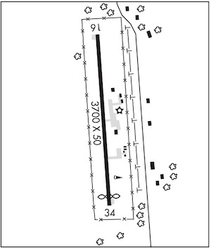
| Runways: | 16/34 |
| Longest Runway: | 16/34 is 3700 ft (1128 m) long |
| Runways with an Instrument Approach: |
A30 Airport Runway Details
| Runway 16/34 | 3700 ft x 50 ft (1128 m x 15 m) | |
| Surface: | Asphalt - Good condition - No special surface treatment | |
| Runway Edge Lights: | Medium Intensity | |
Runway Weight Bearing Capacity (in thousands of pounds) |
||
| Single Wheel Landing Gear: | 12.0 | |
Runway 16 |
Runway 34 |
|
Latitude: |
41-33-46.2600N | 41-33-09.7700N |
Longitude: |
122-51-19.3600W | 122-51-16.3400W |
Glide Path Angle: |
0.0 degrees | 0.0 degrees |
Traffic Pattern: |
Right | Left |
Runway Markings Type: |
Basic | Basic |
Runway Markings Condition: |
Good | Good |
Object at End: |
TREE | |
Object Height: |
25 | |
Distance from End: |
710 | |
Object Centerline Offset: |
160 ft. left of centerline | |
REIL: |
No | No |
Touchdown Lights: |
No | No |
Centerline Lights: |
No | No |
Displaced Threshold: |
200 |
Services
Airframe Repair: |
None |
Powerplant Repair: |
None |
Bottled Oxygen: |
None |
Bulk Oxygen: |
None |
Fuel Available: |
100LL |
Landing Fees: |
No |
Parking: |
Tiedowns available |
Other Services: |
Guided fishing tours |
Maps & Diagrams
A30 Sectional
Flight Planning
at skyvector.com
at skyvector.com