Location
Latitude: |
35-54-53.6940N (35.914915) |
Longitude: |
080-27-24.5030W (-80.456806) |
Elevation: |
818.0 feet MSL (249 m MSL) |
Magnetic Variation: |
8.3 W (as of April 2024 from WMM2020 model) |
Time Zone: |
UTC -5.0 (Standard Time) UTC -4.0 (Daylight Savings Time) |
From City: |
05 N.M. NE of Mocksville, North Carolina |
Found On: |
Charlotte Chart |
FAA Region: |
ASO |
Contacts
Manager: |
Privately owned: |
| BRIAN MEADOWS 1105 FORK BIXBY RD ADVANCE, NC 27006 336-998-8101 |
DR. PHILIP MARTIN 3434 EDWARDS MILL RD, SUITE 112-341 RALEIGH, NC 27612 919-571-0081 |
Operations
Airport Status: |
Operational |
Facility Use: |
Public |
Type: |
Airport |
Control tower: |
No |
Attendance (Months/Days/Hours): |
Months/Days/Hours ALL/ALL/0800-1700 |
Boundary ARTCC: |
ZTL (Atlanta) |
Responsible ARTCC: |
ZTL (Atlanta) |
Lighting Schedule: |
SS-SR |
Segmented Circle Indicator: |
No |
Traffic Pattern Altitude (MSL): |
1818 feet (554 m) |
NOTAMs Facility: |
RDU |
NOTAM-D Service: |
Yes |
Based Aircraft
| Single Engine: | 88 |
| Multi Engine: | 2 |
Annual Operations (as of 07/08/2022)
| Total Operations: | 30000 | |
| GA Local: | 24000 | 80.0% |
| GA Itinerant: | 5000 | 16.7% |
| Military Aircraft: | 1000 | 3.3% |
Communications
| CTAF: | 122.700 |
| Unicom: | 122.700 |
| Approach: | GREENSBORO 124.35 124.35 |
| Departure: | GREENSBORO 124.35 124.35 |
Fixed Based Operators (FBOs) & Fuel
(Click on a business for detail)
Please help us keep this information up to date. This is a FREE SERVICE just like everything else on Airport Guide! If you see that a business needs to be added, modified, or deleted please fill out our Update Form.
To add, modify, or delete a business click here.
Please help us keep this information up to date. This is a FREE SERVICE just like everything else on Airport Guide! If you see that a business needs to be added, modified, or deleted please fill out our Update Form.
Area Code: 336 |
| Business Name | Frequency | Phone | Fuel Grade |
|---|---|---|---|
| Twin Lakes Aviation, Inc.
Update FBO info |
Unicom 122.7 | 998-8101 | 100LL |
Flight Service Stations
| Primary | Alternate | |
| FSS on Field: | N | |
| FSS Name (ID): | Raleigh(RDU) | |
| Frequency: | ||
| Toll Free Phone: | 1-800-WX-BRIEF |
Instrument Procedures / Charts
FAA Terminal Procedures valid from 0901Z 03/21/24 to 0901Z 04/18/24.
There are various types of charts available for an airport. They are listed in the Page Type column. Here is a legend for those types:
APD - Airport Diagram
DP - Departure Procedure Charts
HOT - Hot Spots
IAP - Instrument Approach Procedure Charts
MIN - Minimums
STAR - Standard Terminal Arrival Charts
| Page Type | Page Name | Volume | Action Since Last Cycle |
|---|---|---|---|
| IAP | RNAV (GPS) RWY 09 | SE-2 | |
| MIN | TAKEOFF MINIMUMS | SE-2 |
Terminal Procedures are only available for airports in several countries with more being added all the time. If you are looking for a specific country's charts, please send an email to support(at)airportguide.com stating the country name. This will be used to prioritize the implementation.
Navigation Aids (Navaids) near 8A7
| Dist (NM) | ID | Morse Code | Name | Type | Freq | True Hdg | Mag Hdg |
|---|---|---|---|---|---|---|---|
| 11.0 | RU | . _ . . . _ | Rovdy | NDB | 275 | 188 | 196 |
| 16.9 | IN | . . _ . | Reeno | NDB | 317 | 56 | 64 |
| 24.6 | GSO | _ _ . . . . _ _ _ | Greensboro | VORTAC | 116.20 | 71 | 79 |
| 27.1 | ZEF | _ _ . . . . . _ . | Zephyr | NDB | 326 | 331 | 339 |
| 28.3 | AZW | . _ _ _ . . . _ _ | Mount Airy | NDB | 223 | 351 | 359 |
| 31.4 | VU | . . . _ . . _ | Aller | NDB | 346 | 144 | 152 |
| 33.3 | UKF | . . _ _ . _ . . _ . | Wilki | NDB | 209 | 291 | 299 |
| 38.1 | IZN | . . _ _ . . _ . | Lincolnton | NDB | 432 | 233 | 241 |
| 38.2 | BZM | _ . . . _ _ . . _ _ | Barretts Mountain | VOR-DME | 113.75 | 266 | 274 |
| 41.5 | LIB | . _ . . . . _ . . . | Liberty | VORTAC | 113.00 | 98 | 107 |
| 42.0 | HK | . . . . _ . _ | Tawba | NDB | 332 | 259 | 267 |
| 42.5 | HB | . . . . _ . . . | Alamm | NDB | 361 | 84 | 93 |
| 43.2 | OQA | _ _ _ _ _ . _ . _ | Rockingham County | FAN MARKER | 44 | 53 | |
| 43.8 | SIF | . . . . . . . _ . | Slammer | NDB | 423 | 50 | 59 |
| 46.6 | HKY | . . . . _ . _ _ . _ _ | Hickory Regional | VOT | 110.00 | 257 | 265 |
| 48.1 | CLT | _ . _ . . _ . . _ | Charlotte | VOT | 112.00 | 210 | 218 |
| 48.2 | UV | . . _ . . . _ | Bales | NDB | 396 | 32 | 41 |
| 49.7 | CLT | _ . _ . . _ . . _ | Charlotte | VOR-DME | 115.00 | 209 | 217 |
| 52.2 | JUH | . _ _ _ . . _ . . . . | Ashee | NDB | 410 | 306 | 314 |
| 53.8 | HLX | . . . . . _ . . _ . . _ | Hillsville | NDB | 269 | 340 | 348 |
Nearby Airports with Fuel
Notices to Airmen (NOTAMS)
Remarks
| A110*G | THIS AIRPORT HAS BEEN SURVEYED BY THE NATIONAL GEODETIC SURVEY. |
| A110-2 | RWY 09 -18 FT DROP-OFF 150 FT FROM THR LEFT & RIGHT OF CNTRLN. |
| A110-3 | RWY 09 UPHILL GRADE. |
| A110-4 | DEER/MIGRATORY BIRDS OCNLLY ON ARPT. |
| A110-5 | FOR CD CTC GREENSBORO APCH AT 336-333-5119. |
| A110-6 | FOR AFT HRS SVC CTC 336-998-2126. |
| A40-09/27 | RWY 09/27 NSTD LIGHTING DUE TO NUMBER AND LOCATION. |
| A42-09 | RWY 09 MARKINGS NONSTANDARD DUE TO SIZE AND LOCATION. |
| A42-27 | RWY 27 MARKINGS NONSTANDARD DUE TO SIZE AND LOCATION. |
| A57-09 | APCH SLOPE 4:1 TO DSPLCD THR. |
| A58-09 | HAS 8-20 FT BRUSH STARTING 0-200 FT FM THR OFFSET 19-125 FT R OF CNTRLN AND HAS 8-28 FT BRUSH 0-150 FT FM THR OFFSET 30-90 FT L OF CNTRLN. |
| A70-FUEL-10 | 0LL 24 HR SELF SERVICE WITH CC. |
Runways
Runway Summary
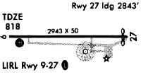
| Runways: | 09/27 |
| Longest Runway: | 09/27 is 2943 ft (897 m) long |
| Runways with an Instrument Approach: |
8A7 Airport Runway Details
| Runway 09/27 | 2943 ft x 50 ft (897 m x 15 m) | |
| Surface: | Asphalt - Good condition - No special surface treatment | |
| Runway Edge Lights: | Non-standard lighting system Intensity | |
Runway Weight Bearing Capacity (in thousands of pounds) |
||
| Single Wheel Landing Gear: | 12.5 | |
Runway 09 |
Runway 27 |
|
Elevation: |
773.0 | 818.0 |
Latitude: |
35-54-53.1980N | 35-54-54.1760N |
Longitude: |
080-27-42.4160W | 080-27-06.6600W |
|
Runway True Alignment: |
088 | 268 |
Glide Path Angle: |
3.5 degrees | 0.0 degrees |
Runway Markings Type: |
Nonstandard (other than numbers only) | Nonstandard (other than numbers only) |
Runway Markings Condition: |
Good | Good |
Object at End: |
TREES | TREES |
Object Height: |
64 | 68 |
Distance from End: |
428 | 399 |
Object Centerline Offset: |
139 ft. right of centerline | 185 ft. right of centerline |
Visual Glide Slope Indicators: |
2-Light PAPI On Left Side Of Runway | |
Threshold Crossing Height: |
49 |
Services
Airframe Repair: |
Major |
Powerplant Repair: |
Major |
Bottled Oxygen: |
None |
Bulk Oxygen: |
None |
Fuel Available: |
100LL |
Landing Fees: |
No |
Parking: |
Tiedowns available |
Maps & Diagrams
8A7 Sectional
Flight Planning
at skyvector.com
at skyvector.com