Location
Latitude: |
32-53-00.5430N (32.883484) |
Longitude: |
090-27-50.3630W (-90.46399) |
Elevation: |
104.6 feet MSL (32 m MSL) |
Magnetic Variation: |
1.4 W (as of April 2024 from WMM2020 model) |
Time Zone: |
UTC -6.0 (Standard Time) UTC -5.0 (Daylight Savings Time) |
From City: |
04 N.M. NW of Yazoo City, Mississippi |
Found On: |
Memphis Chart |
FAA Region: |
ASO |
Contacts
Manager: |
Publicly owned: |
| MICHAEL MCCAIN 51 AIRWAYS RD YAZOO CITY, MS 39194 662-571-1392 |
COUNTY OF YAZOO PO BOX 172 YAZOO CITY, MS 39194 662-746-1273 |
Operations
Airport Status: |
Operational |
Facility Use: |
Public |
Type: |
Airport |
Activation Date: |
11/1989 |
Control tower: |
No |
Attendance (Months/Days/Hours): |
Months/Days/Hours Unattended |
Boundary ARTCC: |
ZME (Memphis) |
Responsible ARTCC: |
ZME (Memphis) |
Lighting Schedule: |
SEE RMK |
Segmented Circle Indicator: |
Yes |
Traffic Pattern Altitude (MSL): |
1105 feet (337 m) |
NOTAMs Facility: |
GWO |
NOTAM-D Service: |
Yes |
Based Aircraft
| Single Engine: | 8 |
| Multi Engine: | 1 |
| GA Helicopters: | 2 |
Annual Operations (as of 02/24/2022)
| Total Operations: | 8625 | |
| GA Local: | 7439 | 86.2% |
| GA Itinerant: | 1078 | 12.5% |
| Military Aircraft: | 108 | 1.3% |
Communications
| CTAF: | 122.800 |
| Unicom: | 122.800 |
- APCH/DEP SVC PRVDD BY MEMPHIS ARTCC ON FREQS 132.5/259.1 (JACKSON RCAG).
Fixed Based Operators (FBOs) & Fuel
(Click on a business for detail)
Please help us keep this information up to date. This is a FREE SERVICE just like everything else on Airport Guide! If you see that a business needs to be added, modified, or deleted please fill out our Update Form.
To add, modify, or delete a business click here.
Please help us keep this information up to date. This is a FREE SERVICE just like everything else on Airport Guide! If you see that a business needs to be added, modified, or deleted please fill out our Update Form.
Area Code: 662 |
| Business Name | Frequency | Phone | Fuel Grade |
|---|
Flight Service Stations
| Primary | Alternate | |
| FSS on Field: | ||
| FSS Name (ID): | Greenwood(GWO) | |
| Frequency: | ||
| Toll Free Phone: | 1-800-WX-BRIEF |
Instrument Procedures / Charts
FAA Terminal Procedures valid from 0901Z 03/21/24 to 0901Z 04/18/24.
There are various types of charts available for an airport. They are listed in the Page Type column. Here is a legend for those types:
APD - Airport Diagram
DP - Departure Procedure Charts
HOT - Hot Spots
IAP - Instrument Approach Procedure Charts
MIN - Minimums
STAR - Standard Terminal Arrival Charts
| Page Type | Page Name | Volume | Action Since Last Cycle |
|---|---|---|---|
| IAP | RNAV (GPS) RWY 17 | SC-4 | |
| IAP | RNAV (GPS) RWY 35 | SC-4 | |
| MIN | TAKEOFF MINIMUMS | SC-4 |
Terminal Procedures are only available for airports in several countries with more being added all the time. If you are looking for a specific country's charts, please send an email to support(at)airportguide.com stating the country name. This will be used to prioritize the implementation.
Navigation Aids (Navaids) near 87I
| Dist (NM) | ID | Morse Code | Name | Type | Freq | True Hdg | Mag Hdg |
|---|---|---|---|---|---|---|---|
| 27.1 | JAN | . _ _ _ . _ _ . | Jackson | VORTAC | 112.60 | 146 | 147 |
| 30.0 | JH | . _ _ _ . . . . | Brenz | NDB | 260 | 160 | 161 |
| 32.6 | MHZ | _ _ . . . . _ _ . . | Magnolia | VORTAC | 113.20 | 145 | 147 |
| 33.2 | JA | . _ _ _ . _ | Allen | NDB | 365 | 148 | 150 |
| 35.1 | RYB | . _ . _ . _ _ _ . . . | Raymond | NDB | 375 | 175 | 176 |
| 36.1 | SQS | . . . _ _ . _ . . . | Sidon | VORTAC | 114.70 | 15 | 16 |
| 36.7 | BLE | _ . . . . _ . . . | Lake Providence | NDB | 278 | 265 | 266 |
| 39.9 | JAN | . _ _ _ . _ _ . | Jackson | VOT | 111.00 | 149 | 151 |
| 41.6 | MTQ | _ _ _ _ _ . _ | Metcalf | NDB | 359 | 321 | 322 |
| 46.4 | GLH | _ _ . . _ . . . . . . | Greenville | VOR-DME | 114.25 | 325 | 326 |
| 46.6 | GW | _ _ . . _ _ | Teock | NDB | 349 | 24 | 26 |
| 47.7 | TKH | _ _ . _ . . . . | Tallulah | NDB | 344 | 216 | 217 |
| 67.3 | SBQ | . . . _ . . . _ _ . _ | Scobey | NDB | 245 | 25 | 27 |
| 72.0 | BQP | _ . . . _ _ . _ . _ _ . | Bastrop | NDB | 329 | 264 | 265 |
| 72.2 | MRK | _ _ . _ . _ . _ | Molly Ridge | NDB | 338 | 247 | 248 |
| 74.9 | MON | _ _ _ _ _ _ . | Monticello | DME | 111.6 | 303 | 304 |
| 82.4 | MLU | _ _ . _ . . . . _ | Monroe | VORTAC | 117.20 | 254 | 255 |
| 83.0 | HAH | . . . . . _ . . . . | Natchez-Adams County | NDB | 388 | 210 | 211 |
| 86.8 | ML | _ _ . _ . . | Sabar | NDB | 392 | 253 | 254 |
| 87.0 | HEZ | . . . . . _ _ . . | Natchez | VOR-DME | 110.00 | 209 | 210 |
Nearby Airports with Fuel
Notices to Airmen (NOTAMS)
Remarks
| A110-1 | FOR CD CTC MEMPHIS ARTCC AT 901-368-8453/8449. |
| A110-2 | FUEL AVBL 24 HRS WITH CREDIT CARD. |
| A110-3 | COURTESY CAR AVBL. |
| A16 | MICHAEL.MCCAIN@YAZOOCOUNTYMS.GOV. |
| A75 | PILOTS MUST PRVD TIEDOWN ROPES. |
| A81-APT | MIRL RWY 17/35 PRESET LOW INTST DUSK - 2200; AFT 2200 ACTVT OR INCR INTST - CTAF. |
Runways
Runway Summary
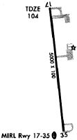
| Runways: | 17/35 |
| Longest Runway: | 17/35 is 5000 ft (1524 m) long |
| Runways with an Instrument Approach: |
87I Airport Runway Details
| Runway 17/35 | 5000 ft x 100 ft (1524 m x 30 m) | |
| Runway Length Source: | 3RD PARTY SURVEY as of 08/11/2021 | |
| Surface: | Asphalt - Fair condition - No special surface treatment | |
| Runway Edge Lights: | Medium Intensity | |
Runway Weight Bearing Capacity (in thousands of pounds) |
||
| Single Wheel Landing Gear: | 30.0 | |
| Dual Tandem Wheel Landing Gear: | 64.0 | |
Runway 17 |
Runway 35 |
|
Elevation: |
104.3 | 104.2 |
Latitude: |
32-53-25.1486N | 32-52-35.9382N |
Longitude: |
090-27-53.3537W | 090-27-47.3730W |
|
Runway True Alignment: |
174 | 354 |
Glide Path Angle: |
3.0 degrees | 3.0 degrees |
Runway Markings Type: |
Nonprecision Instrument | Nonprecision Instrument |
Runway Markings Condition: |
Good | Good |
Object at End: |
TREES | |
Object Height: |
53 | |
Distance from End: |
1590 | |
Object Centerline Offset: |
0 ft. left and right of centerline | |
Visual Glide Slope Indicators: |
2-Light PAPI On Left Side Of Runway | 2-Light PAPI On Left Side Of Runway |
Threshold Crossing Height: |
40 | 40 |
Services
Airframe Repair: |
None |
Powerplant Repair: |
None |
Bottled Oxygen: |
None |
Bulk Oxygen: |
None |
Fuel Available: |
100LL |
Landing Fees: |
No |
Parking: |
Tiedowns available |
Maps & Diagrams
87I Sectional
Flight Planning
at skyvector.com
at skyvector.com