Location
Latitude: |
37-08-54.1870N (37.148385) |
Longitude: |
096-11-06.9710W (-96.18527) |
Elevation: |
1005.0 feet MSL (306 m MSL) |
Magnetic Variation: |
2.3 E (as of April 2024 from WMM2020 model) |
Time Zone: |
UTC -6.0 (Standard Time) UTC -5.0 (Daylight Savings Time) |
From City: |
02 N.M. N of Sedan, Kansas |
Found On: |
Kansas City Chart |
FAA Region: |
ACE |
Contacts
Manager: |
Privately owned: |
| JOHN MILLER CITY HALL SEDAN, KS 67361 (620) 550-1195 |
CITY OF SEDAN CITY HALL SEDAN, KS 67361 620-725-3193 |
Operations
Airport Status: |
Operational |
Facility Use: |
Public |
Type: |
Airport |
Activation Date: |
08/1968 |
Control tower: |
No |
Attendance (Months/Days/Hours): |
Months/Days/Hours Unattended |
Boundary ARTCC: |
ZKC (Kansas City) |
Responsible ARTCC: |
ZKC (Kansas City) |
Lighting Schedule: |
SEE RMK |
Segmented Circle Indicator: |
Yes |
Traffic Pattern Altitude (MSL): |
2005 feet (611 m) |
NOTAMs Facility: |
ICT |
NOTAM-D Service: |
Yes |
Based Aircraft
Annual Operations (as of 09/11/2018)
| Total Operations: | 300 | |
| GA Local: | 200 | 66.7% |
| GA Itinerant: | 100 | 33.3% |
Communications
| CTAF: | 122.900 |
Fixed Based Operators (FBOs) & Fuel
(Click on a business for detail)
Please help us keep this information up to date. This is a FREE SERVICE just like everything else on Airport Guide! If you see that a business needs to be added, modified, or deleted please fill out our Update Form.
To add, modify, or delete a business click here.
Please help us keep this information up to date. This is a FREE SERVICE just like everything else on Airport Guide! If you see that a business needs to be added, modified, or deleted please fill out our Update Form.
Area Code: 620 |
| Business Name | Frequency | Phone | Fuel Grade |
|---|
Flight Service Stations
| Primary | Alternate | |
| FSS on Field: | N | |
| FSS Name (ID): | Wichita(ICT) | |
| Frequency: | ||
| Toll Free Phone: | 1-800-WX-BRIEF |
Instrument Procedures / Charts
Terminal Procedures are only available for airports in several countries with more being added all the time. If you are looking for a specific country's charts, please send an email to support(at)airportguide.com stating the country name. This will be used to prioritize the implementation.
Navigation Aids (Navaids) near 61K
| Dist (NM) | ID | Morse Code | Name | Type | Freq | True Hdg | Mag Hdg |
|---|---|---|---|---|---|---|---|
| 20.3 | BV | _ . . . . . . _ | Dewie | NDB | 201 | 156 | 154 |
| 20.5 | BVO | _ . . . . . . _ _ _ _ | Bartlesville | VOR-DME | 117.90 | 156 | 154 |
| 29.6 | CFV | _ . _ . . . _ . . . . _ | Coffeyville | NDB | 212 | 96 | 94 |
| 40.2 | CNU | _ . _ . _ . . . _ | Chanute | VOR-DME | 109.20 | 44 | 42 |
| 40.9 | SO | . . . _ _ _ | Sawcy | NDB | 353 | 265 | 262 |
| 46.9 | OSW | _ _ _ . . . . _ _ | Oswego | DME | 117.6 | 89 | 87 |
| 48.0 | PN | . _ _ . _ . | Ponca | NDB | 515 | 246 | 243 |
| 52.6 | PER | . _ _ . . . _ . | Pioneer | VORTAC | 113.20 | 243 | 240 |
| 53.2 | MSB | _ _ . . . _ . . . | Monarch | NDB | 410 | 43 | 41 |
| 58.5 | EGT | . _ _ . _ | Wellington | NDB | 414 | 280 | 277 |
| 58.5 | OWP | _ _ _ . _ _ . _ _ . | William Pogue | NDB | 362 | 178 | 176 |
| 58.7 | TUL | _ . . _ . _ . . | Tulsa Intl | VOT | 109.00 | 165 | 163 |
| 58.9 | IAB | . . . _ _ . . . | Mc Connell | TACAN | 116.50 | 299 | 296 |
| 60.2 | TUL | _ . . _ . _ . . | Tulsa | VORTAC | 114.40 | 161 | 159 |
| 64.7 | TU | _ . . _ | Oillr | NDB | 338 | 167 | 165 |
| 65.8 | IC | . . _ . _ . | Piche | NDB | 332 | 293 | 290 |
| 66.3 | ICT | . . _ . _ . _ | Wichita | VOT | 114.00 | 296 | 293 |
| 68.6 | EMP | . _ _ . _ _ . | Emporia | VORTAC | 112.80 | 1 | 359 |
| 69.8 | SW | . . . . _ _ | Gabeh | NDB | 255 | 218 | 215 |
| 70.2 | SWO | . . . . _ _ _ _ _ | Stillwater | VOR-DME | 108.40 | 218 | 215 |
Nearby Airports with Fuel
Notices to Airmen (NOTAMS)
Remarks
| A11 | LEASED TO CITY OF SEDAN. |
| A110-1 | WILDLIFE AND LIVESTOCK IN THE VICINITY AND POSSIBLY ON THE RY. |
| A110-2 | FOR CD CTC KANSAS CITY ARTCC AT 913-254-8508. |
| A16 | HOME NUMBER (620) 725-3429 |
| A52-12 | ROAD 20 FT FM RY END; PLINE AT 450 FT. |
| A81-APT | ACTVT LIRL RY 18/36 - CTAF. |
| A84 | SEGMENTED CIRCLE NSTD. |
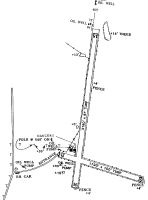
Runways
Runway Summary
| Runways: | 12/30 18/36 |
| Longest Runway: | 18/36 is 3160 ft (963 m) long |
| Runways with an Instrument Approach: |
61K Airport Runway Details
| Runway 12/30 | 1790 ft x 95 ft (546 m x 29 m) | |
| Surface: | Turf - Fair condition - No special surface treatment | |
Runway 12 |
Runway 30 |
|
Glide Path Angle: |
0.0 degrees | 0.0 degrees |
Traffic Pattern: |
Left | Left |
Object at End: |
FENCE | TREES |
Object Height: |
4 | 10 |
Distance from End: |
0 | 15 |
Object Centerline Offset: |
0 ft. left and right of centerline | 12 ft. right of centerline |
| Runway 18/36 | 3160 ft x 81 ft (963 m x 25 m) | |
| Surface: | Turf - Fair condition - No special surface treatment | |
| Runway Edge Lights: | Low Intensity | |
Runway 18 |
Runway 36 |
|
Latitude: |
37-09-14.1800N | 37-08-43.3000N |
Longitude: |
096-11-03.9700W | 096-11-09.9500W |
Glide Path Angle: |
0.0 degrees | 0.0 degrees |
Traffic Pattern: |
Left | Left |
Object at End: |
TREES | TREES |
Object Height: |
24 | 10 |
Distance from End: |
115 | 110 |
Object Centerline Offset: |
0 ft. left and right of centerline | 12 ft. right of centerline |
Services
Airframe Repair: |
Major |
Powerplant Repair: |
Major |
Bottled Oxygen: |
None |
Bulk Oxygen: |
None |
Fuel Available: |
100LL, Jet A |
Landing Fees: |
No |
Parking: |
Hangars and tiedowns available |
Maps & Diagrams
61K Sectional
Flight Planning
at skyvector.com
at skyvector.com