Location
Latitude: |
35-01-11.4950N (35.01986) |
Longitude: |
079-11-27.6140W (-79.191004) |
Elevation: |
304.0 feet MSL (93 m MSL) |
Magnetic Variation: |
8.9 W (as of April 2024 from WMM2020 model) |
Time Zone: |
UTC -5.0 (Standard Time) UTC -4.0 (Daylight Savings Time) |
From City: |
03 N.M. NE of Raeford, North Carolina |
Found On: |
Charlotte Chart |
FAA Region: |
ASO |
Contacts
Manager: |
Privately owned: |
| JOEY D'ANNUNZIO 155 AIRPORT DRIVE RAEFORD, NC 28376 (910) 904-0000 |
BILLIE THACKER PO DRAWER 1510 RAEFORD, NC 28376 910-875-3261 |
Operations
Airport Status: |
Operational |
Facility Use: |
Public |
Type: |
Airport |
Activation Date: |
05/1964 |
Control tower: |
No |
Attendance (Months/Days/Hours): |
Months/Days/Hours ALL/ALL/0830-DUSK |
Boundary ARTCC: |
ZDC (Washington) |
Responsible ARTCC: |
ZDC (Washington) |
Segmented Circle Indicator: |
Yes |
Traffic Pattern Altitude (MSL): |
1304 feet (397 m) |
NOTAMs Facility: |
RDU |
NOTAM-D Service: |
Yes |
International Airport of Entry: |
No |
Customs Landing Rights: |
No |
Military Landing Rights: |
Yes |
Civil/Military Joint Use: |
No |
Based Aircraft
| Single Engine: | 2 |
| Multi Engine: | 6 |
Annual Operations (as of 07/29/2022)
| Total Operations: | 23500 | |
| GA Local: | 18000 | 76.6% |
| GA Itinerant: | 500 | 2.1% |
| Military Aircraft: | 5000 | 21.3% |
Communications
| CTAF: | 123.000 |
| Unicom: | 123.000 |
| Approach: | FAYETTEVILLE 127.8 127.8 |
| Departure: | FAYETTEVILLE 127.8 127.8 |
Fixed Based Operators (FBOs) & Fuel
(Click on a business for detail)
Please help us keep this information up to date. This is a FREE SERVICE just like everything else on Airport Guide! If you see that a business needs to be added, modified, or deleted please fill out our Update Form.
To add, modify, or delete a business click here.
Please help us keep this information up to date. This is a FREE SERVICE just like everything else on Airport Guide! If you see that a business needs to be added, modified, or deleted please fill out our Update Form.
Area Code: 910 |
| Business Name | Frequency | Phone | Fuel Grade |
|---|
Flight Service Stations
| Primary | Alternate | |
| FSS on Field: | N | |
| FSS Name (ID): | Raleigh(RDU) | |
| Frequency: | ||
| Toll Free Phone: | 1-800-WX-BRIEF |
Instrument Procedures / Charts
FAA Terminal Procedures valid from 0901Z 03/21/24 to 0901Z 04/18/24.
There are various types of charts available for an airport. They are listed in the Page Type column. Here is a legend for those types:
APD - Airport Diagram
DP - Departure Procedure Charts
HOT - Hot Spots
IAP - Instrument Approach Procedure Charts
MIN - Minimums
STAR - Standard Terminal Arrival Charts
| Page Type | Page Name | Volume | Action Since Last Cycle |
|---|---|---|---|
| IAP | RNAV (GPS)-A | SE-2 | |
| IAP | VOR-A | SE-2 | |
| MIN | TAKEOFF MINIMUMS | SE-2 |
Terminal Procedures are only available for airports in several countries with more being added all the time. If you are looking for a specific country's charts, please send an email to support(at)airportguide.com stating the country name. This will be used to prioritize the implementation.
Navigation Aids (Navaids) near 5W4
| Dist (NM) | ID | Morse Code | Name | Type | Freq | True Hdg | Mag Hdg |
|---|---|---|---|---|---|---|---|
| 12.3 | POB | . _ _ . _ _ _ _ . . . | Pope | TACAN | 113.80 | 43 | 52 |
| 14.5 | HFF | . . . . . . _ . . . _ . | Mackall | NDB | 278 | 271 | 280 |
| 15.7 | FAY | . . _ . . _ _ . _ _ | Fayetteville | VOR-DME | 114.85 | 97 | 106 |
| 17.0 | POB | . _ _ . _ _ _ _ . . . | Pope | NDB | 338 | 43 | 52 |
| 19.9 | FGP | . . _ . _ _ . . _ _ . | Fort Bragg | NDB | 393 | 68 | 77 |
| 21.2 | ME | _ _ . | Maxtn | NDB | 257 | 215 | 224 |
| 21.3 | EEJ | . . . _ _ _ | Lee County/Dcmsnd | NDB | 428 | 355 | 364 |
| 22.7 | SDZ | . . . _ . . _ _ . . | Sandhills | VORTAC | 111.80 | 301 | 310 |
| 25.2 | RSY | . _ . . . . _ . _ _ | Robeson | NDB | 359 | 165 | 174 |
| 25.4 | LBT | . _ . . _ . . . _ | Lumberton | VOR | 110.00 | 164 | 173 |
| 28.6 | JB | . _ _ _ _ . . . | Jigel | NDB | 384 | 174 | 183 |
| 28.8 | TT | _ _ | Leeco | NDB | 406 | 4 | 13 |
| 35.3 | DLC | _ . . . _ . . _ . _ . | Dillon | NDB | 274 | 194 | 203 |
| 35.4 | HQT | . . . . _ _ . _ _ | Harnett | NDB | 417 | 45 | 54 |
| 35.9 | BES | _ . . . . . . . | Bennettsville | NDB | 230 | 228 | 237 |
| 37.2 | CQW | _ . _ . _ _ . _ . _ _ | Cheraw | NDB | 409 | 243 | 252 |
| 40.8 | CTZ | _ . _ . _ _ _ . . | Clinton | NDB | 412 | 93 | 102 |
| 44.4 | TGQ | _ _ _ . _ _ . _ | Elizabethtown | NDB | 398 | 131 | 140 |
| 46.4 | JN | . _ _ _ _ . | Jurly | NDB | 263 | 53 | 62 |
| 48.7 | UDG | . . _ _ . . _ _ . | Darlington | NDB | 245 | 224 | 233 |
Nearby Airports with Fuel
Notices to Airmen (NOTAMS)
Remarks
| A110*G | THIS AIRPORT HAS BEEN SURVEYED BY THE NATIONAL GEODETIC SURVEY. |
| A110-1 | CAUTION: LOW FLYING MIL ACFT IN AREA; ARPT LCTD WITHIN AN MOA. |
| A110-2 | FRQ PRCHT ACT TO TARGET 300 FT SE OF TERMINAL APRON. |
| A110-3 | ACFT IN VICINITY MONITOR 123.5. |
| A110-4 | FLY ONE MILE DOWN WIND LEG TO PREVENT CONFLICTS WITH PAJA (DROP ZONE SOUTHEAST FROM RWY). |
| A110-5 | AFTER HOURS SVC 910-578-4401. |
| A110-6 | MONITOR FREQ 123.5 FOR PAJA. |
| A110-7 | FOR CD CTC WASHINGTON ARTCC AT 703-771-3587. |
| A110-8 | CTN DO NOT OVERFLY AIRPORT DUE TO PAJA. |
| A58-22 | HAS 15 FT BRUSH 0-200 FT FM THR OFFSET 121 FT R OF CNTRLN. |
Runways
Runway Summary
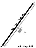
| Runways: | 04/22 |
| Longest Runway: | 04/22 is 3402 ft (1037 m) long |
| Runways with an Instrument Approach: |
5W4 Airport Runway Details
| Runway 04/22 | 3402 ft x 60 ft (1037 m x 18 m) | |
| Surface: | Asphalt - Good condition - No special surface treatment | |
| Runway Edge Lights: | Medium Intensity | |
Runway Weight Bearing Capacity (in thousands of pounds) |
||
| Single Wheel Landing Gear: | 30.0 | |
Runway 04 |
Runway 22 |
|
Elevation: |
292.0 | 304.0 |
Latitude: |
35-00-57.4190N | 35-01-25.5630N |
Longitude: |
079-11-38.8380W | 079-11-16.4190W |
|
Runway True Alignment: |
033 | 213 |
Glide Path Angle: |
0.0 degrees | 0.0 degrees |
Traffic Pattern: |
Left | Right |
Runway Markings Type: |
Nonprecision Instrument | Nonprecision Instrument |
Runway Markings Condition: |
Good | Good |
Object at End: |
TREES | TREES |
Object Height: |
63 | 41 |
Distance from End: |
631 | 615 |
Object Centerline Offset: |
66 ft. right of centerline | 42 ft. left of centerline |
Services
Airframe Repair: |
None |
Powerplant Repair: |
None |
Bottled Oxygen: |
None |
Bulk Oxygen: |
None |
Fuel Available: |
100LL, Jet A |
Landing Fees: |
No |
Parking: |
Hangars and tiedowns available |
Maps & Diagrams
5W4 Sectional
Flight Planning
at skyvector.com
at skyvector.com