Location
Latitude: |
41-38-12.0000N (41.636667) |
Longitude: |
082-49-42.0000W (-82.828333) |
Elevation: |
595.0 feet MSL (181 m MSL) |
Magnetic Variation: |
7.6 W (as of April 2024 from WMM2020 model) |
Time Zone: |
UTC -5.0 (Standard Time) UTC -4.0 (Daylight Savings Time) |
From City: |
01 N.M. SW of Put In Bay, Ohio |
Found On: |
Detroit Chart |
FAA Region: |
AGL |
Contacts
Manager: |
Publicly owned: |
| ROSANN KEISER PO BOX 278 PUT IN BAY, OH 43456-0278 419-285-3371 |
PUT IN BAY TOWNSHIP PORT AUTH PO BOX 278 PUT IN BAY, OH 43456-0278 419-285-3371 |
Operations
Airport Status: |
Operational |
Facility Use: |
Public |
Type: |
Airport |
Activation Date: |
12/1938 |
Control tower: |
No |
Attendance (Months/Days/Hours): |
Months/Days/Hours ALL/ALL/IREG |
Boundary ARTCC: |
ZOB (Cleveland) |
Responsible ARTCC: |
ZOB (Cleveland) |
Segmented Circle Indicator: |
Yes |
Traffic Pattern Altitude (MSL): |
1595 feet (486 m) |
NOTAMs Facility: |
CLE |
NOTAM-D Service: |
Yes |
International Airport of Entry: |
No |
Customs Landing Rights: |
No |
Military Landing Rights: |
No |
Civil/Military Joint Use: |
No |
Based Aircraft
| Single Engine: | 10 |
| GA Helicopters: | 1 |
Annual Operations (as of 10/01/2021)
| Total Operations: | 15126 | |
| Air Taxi: | 7250 | 47.9% |
| GA Local: | 1576 | 10.4% |
| GA Itinerant: | 6300 | 41.7% |
Communications
| CTAF: | 122.800 |
| Unicom: | 122.800 |
Fixed Based Operators (FBOs) & Fuel
(Click on a business for detail)
Please help us keep this information up to date. This is a FREE SERVICE just like everything else on Airport Guide! If you see that a business needs to be added, modified, or deleted please fill out our Update Form.
To add, modify, or delete a business click here.
Please help us keep this information up to date. This is a FREE SERVICE just like everything else on Airport Guide! If you see that a business needs to be added, modified, or deleted please fill out our Update Form.
Area Code: 419 |
| Business Name | Frequency | Phone | Fuel Grade |
|---|---|---|---|
| Put-in-Bay Twp. Port Authority
Update FBO info |
Unicom 122.8 | 285-3371 |
Flight Service Stations
| Primary | Alternate | |
| FSS on Field: | N | |
| FSS Name (ID): | Cleveland(CLE) | |
| Frequency: | ||
| Toll Free Phone: | 1-800-WX-BRIEF |
Instrument Procedures / Charts
Terminal Procedures are only available for airports in several countries with more being added all the time. If you are looking for a specific country's charts, please send an email to support(at)airportguide.com stating the country name. This will be used to prioritize the implementation.
Navigation Aids (Navaids) near 3W2
| Dist (NM) | ID | Morse Code | Name | Type | Freq | True Hdg | Mag Hdg |
|---|---|---|---|---|---|---|---|
| 7.3 | PCW | . _ _ . _ . _ . . _ _ | Port Clinton | NDB | 423 | 194 | 202 |
| 14.4 | SKY | . . . _ . _ _ . _ _ | Sandusky | VOR-DME | 109.20 | 147 | 155 |
| 31.4 | RYS | . _ . _ . _ _ . . . | Grosse Ile | NDB | 419 | 332 | 340 |
| 34.3 | DJB | _ . . . _ _ _ _ . . . | Dryer | VOR-DME | 113.60 | 118 | 126 |
| 36.8 | YQG | _ . _ _ _ _ . _ _ _ . | Windsor | VOR-DME | 113.80 | 359 | 367 |
| 36.9 | TII | _ . . . . | Tiffin | NDB | 269 | 208 | 215 |
| 37.1 | FZI | . . _ . _ _ . . . . | Fostoria | NDB | 379 | 223 | 230 |
| 37.4 | CRL | _ . _ . . _ . . _ . . | Carleton | VOR-DME | 115.70 | 311 | 318 |
| 37.7 | ZQG | Laurel | NDB | 398 | 345 | 353 | |
| 38.0 | VWV | . . . _ . _ _ . . . _ | Waterville | VOR-DME | 113.10 | 253 | 260 |
| 38.8 | JZJ | . _ _ _ _ _ . . . _ _ _ | Alaina | NDB | 223 | 334 | 342 |
| 40.6 | QG | Windsor | NDB | 353 | 357 | 365 | |
| 42.1 | DXO | _ . . _ . . _ _ _ _ | Detroit | VOR-DME | 113.40 | 325 | 332 |
| 42.8 | DTW | _ . . _ . _ _ | Detroit Met Wayne | VOT | 109.80 | 326 | 333 |
| 43.5 | VQ | . . . _ _ _ . _ | Cargl | NDB | 230 | 352 | 360 |
| 43.6 | TOL | _ _ _ _ . _ . . | Toledo | TACAN | 112.50 | 266 | 273 |
| 45.8 | CLE | _ . _ . . _ . . . | Cleveland | VOT | 110.40 | 106 | 114 |
| 46.9 | DET | _ . . . _ | Detroit City | VOT | 111.60 | 349 | 357 |
| 47.3 | MFD | _ _ . . _ . _ . . | Mansfield | VORTAC | 108.80 | 166 | 174 |
| 47.4 | YIP | _ . _ _ . . . _ _ . | Willow Run | VOT | 108.85 | 319 | 326 |
Nearby Airports with Fuel
Notices to Airmen (NOTAMS)
Remarks
| A110*G | THIS AIRPORT HAS BEEN SURVEYED BY THE NATIONAL GEODETIC SURVEY. |
| A110-10 | FOR CD CTC CLEVELAND APCH AT 216-352-2323. |
| A110-2 | EXP MOD TURB ON APCH/DEP WHEN WIND EXCEEDS 10 KT. |
| A110-3 | ACFT LDG RWY 21 OR DEP RWY 03 RMN 1000 FT CLEAR OF PERRY'S MONUMENT 352 FT AGL (942 FT MSL) 1.3 NM NE OF ARPT. |
| A110-4 | ACFT OPS PROHIBITED DUSK-DAWN. |
| A110-6 | HELIPAD IS FOR TOUCHDOWN, LOADING, & LIFTOFF ONLY - PARK ON GRASS WEST & SW OF HELIPAD. |
| A110-7 | BIRDS & OTR WILDLIFE INVOF ARPT. |
| A110-9 | DECOY COYOTE NEAR MOVEMENT AREAS. |
| A24 | PRKG/RAMP FEES FOR ALL PVT & COML ACFT; ALL PILOTS ARE RQRD TO CK IN AT ARPT OFC AT TIME OF ARR; ALL ACFT RQRD TO SHUT DOWN ENGINE(S) WHEN ENPLANING/DEPLANING PAX. |
| A57-03 | APCH RATIO 17:1 TO DTHR OVR +50 FT TREE, 855 FT DIST, 140 FT B. |
| A57-21 | APCH RATIO 18:1 TO DTHR OVR +65 FT TREES, 1235 FT DIST, 50 FT L. |
| A58-03 | +0-5 FT FENCE, 200 FT DIST, 125 FT R, EXTDG TO 250 FT FM DTHR, 125 FT R. |
| A58-21 | +5 FT FENCE, 200 FT DIST, 120 FT R, EXTDG TO DTHR, 125 FT L & R. |
| A75 | PRIOR CDN RQRD. |
| A75 1 | ROPES NOT PRVDD. |
| E111 | ESTABD BFR 1959. |
Runways
Runway Summary
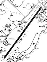
| Runways: | 03/21 |
| Longest Runway: | 03/21 is 2870 ft (875 m) long |
| Runways with an Instrument Approach: |
3W2 Airport Runway Details
| Runway 03/21 | 2870 ft x 75 ft (875 m x 23 m) | |
| Surface: | Asphalt - Good condition - No special surface treatment | |
Runway 03 |
Runway 21 |
|
Elevation: |
592.2 | 594.5 |
Latitude: |
41-38-00.1021N | 41-38-23.8863N |
Longitude: |
082-49-52.2590W | 082-49-31.6803W |
Glide Path Angle: |
0.0 degrees | 0.0 degrees |
Traffic Pattern: |
Right | |
Runway Markings Type: |
Basic | Basic |
Runway Markings Condition: |
Good | Good |
Object at End: |
TREES | FENCE |
Object Height: |
50 | 5 |
Distance from End: |
405 | 201 |
Object Centerline Offset: |
140 ft. left and right of centerline | 120 ft. left and right of centerline |
REIL: |
No | No |
Touchdown Lights: |
No | No |
Centerline Lights: |
No | No |
Threshold Elevation: |
593.4 | 594.5 |
Displaced Threshold: |
450 | 657 |
Threshold Latitude: |
41-38-03.8500N | 41-38-18.4400N |
Threshold Longitude: |
082-49-49.0200W | 082-49-36.3900W |
Services
Airframe Repair: |
None |
Powerplant Repair: |
None |
Bottled Oxygen: |
None |
Bulk Oxygen: |
None |
Fuel Available: |
100LL |
Landing Fees: |
No |
Parking: |
Hangars and tiedowns available |
Maps & Diagrams
3W2 Sectional
Flight Planning
at skyvector.com
at skyvector.com