Location
Latitude: |
39-13-07.3000N (39.218694) |
Longitude: |
075-36-01.7000W (-75.600472) |
Elevation: |
55.2 feet MSL (17 m MSL) |
Magnetic Variation: |
11.6 W (as of April 2024 from WMM2020 model) |
Time Zone: |
UTC -5.0 (Standard Time) UTC -4.0 (Daylight Savings Time) |
From City: |
01 N.M. W of Dover/Cheswold, Delaware |
Found On: |
Washington Chart |
FAA Region: |
AEA |
Contacts
Manager: |
Publicly owned: |
| BENJAMIN S. CLENDANIEL 127 DURHAM LANE DOVER, DE 19904 (302) 571-6312 |
DELAWARE DEPT OF TRANSPORTATION 127 DURHAM LANE DOVER, DE 19904 (302) 571-6312 |
Operations
Airport Status: |
Operational |
Facility Use: |
Public |
Type: |
Airport |
Control tower: |
No |
Attendance (Months/Days/Hours): |
Months/Days/Hours ALL/ALL/0830-1630 |
Boundary ARTCC: |
ZDC (Washington) |
Responsible ARTCC: |
ZDC (Washington) |
Lighting Schedule: |
SEE RMK |
Segmented Circle Indicator: |
Yes |
Traffic Pattern Altitude (MSL): |
1055 feet (322 m) |
NOTAMs Facility: |
MIV |
NOTAM-D Service: |
Yes |
International Airport of Entry: |
No |
Customs Landing Rights: |
No |
Military Landing Rights: |
No |
Civil/Military Joint Use: |
No |
Based Aircraft
| Single Engine: | 43 |
| Multi Engine: | 5 |
Annual Operations (as of 12/31/2022)
| Total Operations: | 30050 | |
| GA Local: | 25500 | 84.9% |
| GA Itinerant: | 4550 | 15.1% |
Communications
| CTAF: | 123.075 |
| Unicom: | 123.075 |
| Clearance Del.: | 125.55 125.55 125.55 125.55 125.55 |
| Approach: | DOVER |
| Departure: | DOVER |
| AWOS-3: | 120.125 (302-571-6012) |
Fixed Based Operators (FBOs) & Fuel
(Click on a business for detail)
Please help us keep this information up to date. This is a FREE SERVICE just like everything else on Airport Guide! If you see that a business needs to be added, modified, or deleted please fill out our Update Form.
To add, modify, or delete a business click here.
Please help us keep this information up to date. This is a FREE SERVICE just like everything else on Airport Guide! If you see that a business needs to be added, modified, or deleted please fill out our Update Form.
Area Code: 732 |
| Business Name | Frequency | Phone | Fuel Grade |
|---|---|---|---|
| Delaware River and Bay Authority
Website Update FBO info |
302-735-5519 | 100LL | |
| Russell Aircraft Refinishers
Update FBO info |
302-674-0461 |
Flight Service Stations
| Primary | Alternate | |
| FSS on Field: | N | |
| FSS Name (ID): | Millville(MIV) | |
| Frequency: | ||
| Toll Free Phone: | 1-800-WX-BRIEF |
Instrument Procedures / Charts
FAA Terminal Procedures valid from 0901Z 03/21/24 to 0901Z 04/18/24.
There are various types of charts available for an airport. They are listed in the Page Type column. Here is a legend for those types:
APD - Airport Diagram
DP - Departure Procedure Charts
HOT - Hot Spots
IAP - Instrument Approach Procedure Charts
MIN - Minimums
STAR - Standard Terminal Arrival Charts
| Page Type | Page Name | Volume | Action Since Last Cycle |
|---|---|---|---|
| IAP | RNAV (GPS) RWY 09 | NE-3 | |
| IAP | RNAV (GPS) RWY 27 | NE-3 | |
| IAP | VOR RWY 27 | NE-3 | |
| MIN | ALTERNATE MINIMUMS | NE-3 | |
| MIN | TAKEOFF MINIMUMS | NE-3 | |
| STAR | ARLFT TWO (RNAV) | NE-3 |
Terminal Procedures are only available for airports in several countries with more being added all the time. If you are looking for a specific country's charts, please send an email to support(at)airportguide.com stating the country name. This will be used to prioritize the implementation.
Navigation Aids (Navaids) near 33N
| Dist (NM) | ID | Morse Code | Name | Type | Freq | True Hdg | Mag Hdg |
|---|---|---|---|---|---|---|---|
| 4.0 | ENO | . _ . _ _ _ | Smyrna | VORTAC | 111.40 | 78 | 90 |
| 8.1 | DOV | _ . . _ _ _ . . . _ | Dover | TACAN | 110.00 | 129 | 141 |
| 21.8 | IL | . . . _ . . | Hadin | NDB | 248 | 358 | 370 |
| 24.7 | RNB | . _ . _ . _ . . . | Rainbow | NDB | 363 | 60 | 72 |
| 27.6 | DQO | _ . . _ _ . _ _ _ _ | Dupont | VORTAC | 114.00 | 359 | 371 |
| 28.6 | OOD | _ _ _ _ _ _ _ . . | Woodstown | VORTAC | 112.80 | 28 | 40 |
| 30.2 | APG | . _ . _ _ . _ _ . | Aberdeen | NDB | 349 | 309 | 321 |
| 30.4 | PPM | . _ _ . . _ _ . _ _ | Phillips | VOR-DME | 108.40 | 299 | 310 |
| 30.5 | ATR | . _ _ . _ . | Waterloo | VOR-DME | 112.60 | 143 | 155 |
| 35.1 | VCN | . . . _ _ . _ . _ . | Cedar Lake | VOR-DME | 115.20 | 56 | 68 |
| 38.0 | SIE | . . . . . . | Sea Isle | VORTAC | 114.80 | 100 | 112 |
| 42.1 | MXE | _ _ _ . . _ . | Modena | VORTAC | 113.20 | 355 | 367 |
| 42.3 | PHL | . _ _ . . . . . . _ . . | Philadelphia | VOT | 109.80 | 23 | 35 |
| 45.6 | CGE | _ . _ . _ _ . . | Cambridge | NDB | 355 | 206 | 217 |
| 47.8 | IUB | . . . . _ _ . . . | Institute | NDB | 404 | 275 | 286 |
| 49.4 | BAL | _ . . . . _ . _ . . | Baltimore | VORTAC | 115.10 | 267 | 278 |
| 49.6 | ACY | . _ _ . _ . _ . _ _ | Atlantic City | VORTAC | 108.60 | 73 | 85 |
| 52.6 | SBY | . . . _ . . . _ . _ _ | Salisbury | VORTAC | 111.20 | 175 | 187 |
| 54.6 | BUH | _ . . . . . _ . . . . | Anne Arundel | NDB | 260 | 261 | 272 |
| 54.7 | OX | _ _ _ _ . . _ | Landy | NDB | 407 | 159 | 171 |
Nearby Airports with Fuel
Notices to Airmen (NOTAMS)
Remarks
| A110-1 | ACFT UN OPS DUE TO SIZE OR FAC ALTN IS DOVER AFB CIV AIR TRML, PPR RQR (302) 571- 6375. |
| A110-10 | TRAN ACFT PRKG N TRML BLDG. ADDNLTRAN PRKG ON APN W OF T HNGRS. E APN CLSD TO TRAN ACFT PRKG. |
| A110-2 | DEER AND BIRDS ON AND INVOF ARPT. |
| A110-3 | MOWING OPS CONDUCTED 0700-1500 APR-OCT. |
| A110-4 | ARPT CONDS UNMON BTN 1630-0830. |
| A110-5 | ACFT NOT VISIBLE ON OPPOSITE END OF RWY DUE TO GRADIENT. |
| A110-6 | FOR CD CTC WASHINGTON ARTCC AT 703-771-3587. |
| A110-7 | SGFNT FIXED WING AND HELI ACFT FLT TRG INVOF AIRPARK. |
| A30A-27 | CALM WIND RWY. |
| A52-09 | 94 FT TREE 0.3 NM WEST OF RWY. |
| A52-27 | 57 FT PWR LN 0.2 NM EAST OF RWY. |
| A70-FUEL-10 | 0LL 24 HR SELF-SERVICE CREDIT CARD FUEL AVBL. |
| A81-APT | ACTVT REIL RWY 09 & 27; MIRL RWY 09/27 - CTAF . |
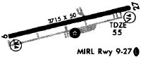
Runways
Runway Summary
| Runways: | 09/27 |
| Longest Runway: | 09/27 is 4201 ft (1280 m) long |
| Runways with an Instrument Approach: |
33N Airport Runway Details
| Runway 09/27 | 4201 ft x 75 ft (1280 m x 23 m) | |
| Runway Length Source: | 3RD PARTY SURVEY as of 10/07/2017 | |
| Surface: | Asphalt - Excellent condition - Saw-cut or plastic grooved | |
| Runway Pavement Class: | 14 /F/C/X/T | |
| Runway Edge Lights: | Medium Intensity | |
Runway Weight Bearing Capacity (in thousands of pounds) |
||
| Single Wheel Landing Gear: | 38.5 | |
| Dual Wheel Landing Gear: | 56.5 | |
Runway 09 |
Runway 27 |
|
Elevation: |
48.6 | 45.2 |
Latitude: |
39-13-01.3627N | 39-13-13.2727N |
Longitude: |
075-36-27.2262W | 075-35-36.0873W |
|
Runway True Alignment: |
073 | 253 |
Glide Path Angle: |
3.0 degrees | 3.0 degrees |
Traffic Pattern: |
Left | Left |
Runway Markings Type: |
Nonprecision Instrument | Nonprecision Instrument |
Runway Markings Condition: |
Good | Good |
Visual Glide Slope Indicators: |
2-Light PAPI On Left Side Of Runway | 2-Light PAPI On Left Side Of Runway |
REIL: |
Yes | Yes |
Threshold Crossing Height: |
43 | 43 |
Services
Airframe Repair: |
None |
Powerplant Repair: |
None |
Bottled Oxygen: |
None |
Bulk Oxygen: |
None |
Fuel Available: |
100LL |
Landing Fees: |
No |
Parking: |
Tiedowns available |
Maps & Diagrams
33N Sectional
Flight Planning
at skyvector.com
at skyvector.com