Location
Latitude: |
43-29-54.1000N (43.498361) |
Longitude: |
115-32-49.1000W (-115.546972) |
Elevation: |
4958.0 feet MSL (1511 m MSL) |
Magnetic Variation: |
12.6 E (as of April 2024 from WMM2020 model) |
Time Zone: |
UTC -7.0 (Standard Time) UTC -6.0 (Daylight Savings Time) |
From City: |
02 N.M. SE of Prairie, Idaho |
Found On: |
Salt Lake City Chart |
FAA Region: |
ANM |
Contacts
Manager: |
Publicly owned: |
| DIV ADMIN P.O. BOX 7129 BOISE, ID 83707-1129 208-334-8775 |
STATE OF ID/ITD - DIV OF AERO P.O. BOX 7129 BOISE, ID 83707-1129 208-334-8775 |
Operations
Airport Status: |
Operational |
Facility Use: |
Public |
Type: |
Airport |
Activation Date: |
02/1961 |
Control tower: |
No |
Attendance (Months/Days/Hours): |
Months/Days/Hours Unattended |
Boundary ARTCC: |
ZLC (Salt Lake City) |
Responsible ARTCC: |
ZLC (Salt Lake City) |
Segmented Circle Indicator: |
Yes |
Traffic Pattern Altitude (MSL): |
5958 feet (1816 m) |
NOTAMs Facility: |
BOI |
NOTAM-D Service: |
Yes |
International Airport of Entry: |
No |
Customs Landing Rights: |
No |
Civil/Military Joint Use: |
No |
Based Aircraft
Annual Operations (as of 07/30/2023)
| Total Operations: | 1400 | |
| GA Itinerant: | 1200 | 85.7% |
| Military Aircraft: | 200 | 14.3% |
Communications
| CTAF: | 122.900 |
Fixed Based Operators (FBOs) & Fuel
(Click on a business for detail)
Please help us keep this information up to date. This is a FREE SERVICE just like everything else on Airport Guide! If you see that a business needs to be added, modified, or deleted please fill out our Update Form.
To add, modify, or delete a business click here.
Please help us keep this information up to date. This is a FREE SERVICE just like everything else on Airport Guide! If you see that a business needs to be added, modified, or deleted please fill out our Update Form.
Area Code: 208 |
| Business Name | Frequency | Phone | Fuel Grade |
|---|
Flight Service Stations
| Primary | Alternate | |
| FSS on Field: | N | |
| FSS Name (ID): | Boise(BOI) | |
| Frequency: | ||
| Toll Free Phone: | 1-800-WX-BRIEF |
Instrument Procedures / Charts
Terminal Procedures are only available for airports in several countries with more being added all the time. If you are looking for a specific country's charts, please send an email to support(at)airportguide.com stating the country name. This will be used to prioritize the implementation.
Navigation Aids (Navaids) near 2U0
| Dist (NM) | ID | Morse Code | Name | Type | Freq | True Hdg | Mag Hdg |
|---|---|---|---|---|---|---|---|
| 23.6 | STI | . . . _ . . | Sturgeon | NDB | 333 | 191 | 178 |
| 28.3 | BOI | _ . . . _ _ _ . . | Boise | VORTAC | 113.30 | 276 | 263 |
| 29.5 | BOI | _ . . . _ _ _ . . | Boise | VOT | 116.70 | 276 | 263 |
| 31.0 | MUO | _ _ . . _ _ _ _ | Mountain Home | TACAN | 114.00 | 207 | 194 |
| 32.5 | LIA | . _ . . . . . _ | Liberator | VOR | 114.90 | 197 | 184 |
| 33.9 | BO | _ . . . _ _ _ | Ustik | NDB | 359 | 280 | 267 |
| 43.6 | MPA | _ _ . _ _ . . _ | Meridian | NDB | 238 | 278 | 265 |
| 51.7 | HDG | . . . . _ . . _ _ . | Steelhead | NDB | 211 | 132 | 120 |
| 57.7 | HLE | . . . . . _ . . . | Hailey | NDB-DME | 220 | 99 | 87 |
| 70.6 | ONO | _ _ _ _ . _ _ _ | Ontario | NDB | 305 | 296 | 283 |
| 76.7 | TWF | _ . _ _ . . _ . | Twin Falls | VORTAC | 113.10 | 142 | 130 |
| 80.5 | TW | _ . _ _ | Strik | NDB | 389 | 139 | 127 |
| 81.2 | DNJ | _ . . _ . . _ _ _ | Donnelly | VOR-DME | 116.20 | 339 | 326 |
| 92.0 | BYI | _ . . . _ . _ _ . . | Burley | VOR-DME | 114.10 | 126 | 114 |
Nearby Airports with Fuel
Notices to Airmen (NOTAMS)
Remarks
| A110-1 | NO WINTER MAINTENANCE. |
| A110-2 | RCMD LAND RWY 06; TKOF RWY 24 WHEN WND COND PERMITS. |
| A110-3 | NO TELEPHONE AVBL AT ARPT. |
| A110-4 | FOR CD CTC BIG SKY APCH AT 208-364-5860/5861. |
| A42-06 | 06/24 EDGES & THRS MARKED WITH WHITE ROCKS. |
| E111 | ESTABD PRIOR TO 1959. |
Runways
Runway Summary
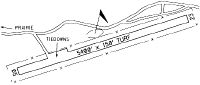
| Runways: | 06/24 |
| Longest Runway: | 06/24 is 5400 ft (1646 m) long |
| Runways with an Instrument Approach: |
2U0 Airport Runway Details
| Runway 06/24 | 5400 ft x 150 ft (1646 m x 46 m) | |
| Surface: | Turf/Dirt - Good condition - No special surface treatment | |
Runway 06 |
Runway 24 |
|
Elevation: |
4870.0 | 4958.0 |
Latitude: |
43-29-45.7700N | 43-30-02.4400N |
Longitude: |
115-33-23.9400W | 115-32-14.3300W |
|
Runway True Alignment: |
071 | 251 |
Glide Path Angle: |
0.0 degrees | 0.0 degrees |
Traffic Pattern: |
Left | Left |
Object at End: |
FENCE | BLDG |
Object Height: |
4 | 12 |
Distance from End: |
0 | 75 |
Object Centerline Offset: |
200 ft. right of centerline | 70 ft. left of centerline |
Services
Airframe Repair: |
None |
Powerplant Repair: |
None |
Bottled Oxygen: |
None |
Bulk Oxygen: |
None |
Fuel Available: |
100LL |
Landing Fees: |
No |
Parking: |
Tiedowns available |
Other Services: |
Cactus Pete's is 1/4 mile from airport. Call casino (755-6020) for code to restroom (current code is 2314). |
Maps & Diagrams
2U0 Sectional
Flight Planning
at skyvector.com
at skyvector.com