Location
Latitude: |
39-18-09.0330N (39.302509) |
Longitude: |
088-00-14.6230W (-88.004062) |
Elevation: |
654.9 feet MSL (200 m MSL) |
Magnetic Variation: |
3.6 W (as of April 2024 from WMM2020 model) |
Time Zone: |
UTC -6.0 (Standard Time) UTC -5.0 (Daylight Savings Time) |
From City: |
01 N.M. NW of Casey, Illinois |
Found On: |
St Louis Chart |
FAA Region: |
AGL |
Contacts
Manager: |
Publicly owned: |
| CHRIS WHITE 2624 E WASHINGTON STREET CASEY, IL 62420 (217) 932-5600 |
CITY OF CASEY PO BOX 425 CASEY, IL 62420 217-932-2700 |
Operations
Airport Status: |
Operational |
Facility Use: |
Public |
Type: |
Airport |
Activation Date: |
03/1947 |
Control tower: |
No |
Attendance (Months/Days/Hours): |
Months/Days/Hours ALL/MON-SAT/0800-1700 |
Boundary ARTCC: |
ZID (Indianapolis) |
Responsible ARTCC: |
ZID (Indianapolis) |
Lighting Schedule: |
SEE RMK |
Segmented Circle Indicator: |
Yes |
Traffic Pattern Altitude (MSL): |
1655 feet (504 m) |
NOTAMs Facility: |
STL |
NOTAM-D Service: |
Yes |
International Airport of Entry: |
No |
Customs Landing Rights: |
No |
Military Landing Rights: |
Yes |
Civil/Military Joint Use: |
No |
Based Aircraft
| Single Engine: | 11 |
Annual Operations (as of 05/31/2022)
| Total Operations: | 8000 | |
| Air Taxi: | 200 | 2.5% |
| GA Local: | 5000 | 62.5% |
| GA Itinerant: | 2750 | 34.4% |
| Military Aircraft: | 50 | 0.6% |
Communications
| CTAF: | 122.800 |
| Unicom: | 122.800 |
| Approach: | HULMAN 125.45 125.45 |
| Departure: | HULMAN 125.45 125.45 |
Fixed Based Operators (FBOs) & Fuel
(Click on a business for detail)
Please help us keep this information up to date. This is a FREE SERVICE just like everything else on Airport Guide! If you see that a business needs to be added, modified, or deleted please fill out our Update Form.
To add, modify, or delete a business click here.
Please help us keep this information up to date. This is a FREE SERVICE just like everything else on Airport Guide! If you see that a business needs to be added, modified, or deleted please fill out our Update Form.
Area Code: 217 |
| Business Name | Frequency | Phone | Fuel Grade |
|---|---|---|---|
| Sky's The Limit
Update FBO info |
Unicom 122.8 | 932-2078 | 100LL |
Flight Service Stations
| Primary | Alternate | |
| FSS on Field: | N | |
| FSS Name (ID): | Saint Louis(STL) | |
| Frequency: | ||
| Toll Free Phone: | 1-800-WX-BRIEF |
Instrument Procedures / Charts
FAA Terminal Procedures valid from 0901Z 03/21/24 to 0901Z 04/18/24.
There are various types of charts available for an airport. They are listed in the Page Type column. Here is a legend for those types:
APD - Airport Diagram
DP - Departure Procedure Charts
HOT - Hot Spots
IAP - Instrument Approach Procedure Charts
MIN - Minimums
STAR - Standard Terminal Arrival Charts
| Page Type | Page Name | Volume | Action Since Last Cycle |
|---|---|---|---|
| IAP | RNAV (GPS) RWY 04 | EC-3 | |
| IAP | RNAV (GPS) RWY 22 | EC-3 | |
| MIN | TAKEOFF MINIMUMS | EC-3 |
Terminal Procedures are only available for airports in several countries with more being added all the time. If you are looking for a specific country's charts, please send an email to support(at)airportguide.com stating the country name. This will be used to prioritize the implementation.
Navigation Aids (Navaids) near 1H8
| Dist (NM) | ID | Morse Code | Name | Type | Freq | True Hdg | Mag Hdg |
|---|---|---|---|---|---|---|---|
| 0.2 | CZB | _ . _ . _ _ . . _ . . . | Casey | NDB | 359 | 30 | 34 |
| 11.5 | MT | _ _ _ | Zebre | NDB | 347 | 316 | 320 |
| 16.8 | MTO | _ _ _ _ _ _ | Mattoon | DME | 109.4 | 308 | 312 |
| 23.8 | RSV | . _ . . . . . . . _ | Robinson | VOR-DME | 108.40 | 135 | 139 |
| 24.2 | PLX | . _ _ . . _ . . _ . . _ | Palestine | NDB | 391 | 135 | 139 |
| 28.3 | SIV | . . . . . . . . _ | Sullivan | NDB | 326 | 113 | 117 |
| 28.6 | HU | . . . . . . _ | Yinno | NDB | 245 | 79 | 83 |
| 31.9 | BIB | _ . . . . . _ . . . | Bible Grove | VORTAC | 109.00 | 224 | 227 |
| 35.9 | OLY | _ _ _ . _ . . _ . _ _ | Olney | NDB | 272 | 192 | 196 |
| 36.8 | TTH | _ _ . . . . | Terre Haute | VORTAC | 115.30 | 72 | 76 |
| 37.0 | LWV | . _ . . . _ _ . . . _ | Lawrenceville | DME | 108.8 | 149 | 153 |
| 39.4 | SYZ | . . . _ . _ _ _ _ . . | Shelbyville | NDB | 365 | 279 | 282 |
| 40.7 | CM | _ . _ . _ _ | Veals | NDB | 407 | 348 | 352 |
| 42.2 | OEA | _ _ _ . . _ | Vincennes | NDB | 251 | 150 | 154 |
| 43.5 | HMJ | . . . . _ _ . _ _ _ | Homer | NDB | 281 | 3 | 7 |
| 45.7 | CMI | _ . _ . _ _ . . | Champaign | VORTAC | 110.00 | 344 | 348 |
| 47.3 | AXC | . _ _ . . _ _ . _ . | Adders | VORTAC | 117.20 | 303 | 306 |
| 49.2 | SAM | . . . . _ _ _ | Samsville | DME | 116.6 | 184 | 188 |
| 49.2 | DEC | _ . . . _ . _ . | Akley | FAN MARKER | 314 | 317 | |
| 52.8 | DE | _ . . . | Elwin | NDB | 275 | 303 | 306 |
Nearby Airports with Fuel
Notices to Airmen (NOTAMS)
Remarks
| A110-1 | FOR CD CTC HULMAN APCH AT 812-877-7581. |
| A15 | EMAIL ADDRESS: LCPTWHITE@YAHOO.COM (ALL LOWER CASE) |
| A16 | OR 908-247-1000 |
| A42-18 | DSPLCD THR MKD WITH WHITE GRAVEL IN SHAPE OF 'L' ON RY EDGES. |
| A57-18 | APCH RATIO 20:1 TO DSPLCD THR. |
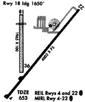
| A58-04 | RWY 4 & 22 HAVE SEASONAL CROPS PENTG PART 77 SFC |
| A81-APT | MIRL RY 04/22 PRESET ON LOW INTST; TO INCR INTST & ACTVT TWY LGTS - CTAF. |
Runways
Runway Summary
| Runways: | 04/22 18/36 |
| Longest Runway: | 04/22 is 4001 ft (1220 m) long |
| Runways with an Instrument Approach: |
1H8 Airport Runway Details
| Runway 04/22 | 4001 ft x 75 ft (1220 m x 23 m) | |
| Runway Length Source: | 3RD PARTY SURVEY as of 03/06/2011 | |
| Surface: | Asphalt - Good condition - No special surface treatment | |
| Runway Edge Lights: | Medium Intensity | |
Runway Weight Bearing Capacity (in thousands of pounds) |
||
| Single Wheel Landing Gear: | 12.0 | |
Runway 04 |
Runway 22 |
|
Elevation: |
653.1 | 654.4 |
Latitude: |
39-17-52.5309N | 39-18-23.2724N |
Longitude: |
088-00-27.5864W | 087-59-55.5712W |
|
Runway True Alignment: |
039 | 219 |
Glide Path Angle: |
0.0 degrees | 0.0 degrees |
Traffic Pattern: |
Left | Right |
Runway Markings Type: |
Nonprecision Instrument | Nonprecision Instrument |
Runway Markings Condition: |
Good | Good |
REIL: |
No | No |
Touchdown Lights: |
No | No |
Centerline Lights: |
No | No |
| Runway 18/36 | 1943 ft x 75 ft (592 m x 23 m) | |
| Runway Length Source: | 3RD PARTY SURVEY as of 03/06/2011 | |
| Surface: | Asphalt - Good condition - No special surface treatment | |
Runway 18 |
Runway 36 |
|
Elevation: |
654.9 | 649.4 |
Latitude: |
39-18-20.9973N | 39-18-01.7934N |
Longitude: |
088-00-20.8072W | 088-00-20.4709W |
|
Runway True Alignment: |
179 | 359 |
Glide Path Angle: |
0.0 degrees | 0.0 degrees |
Traffic Pattern: |
Right | Left |
Object at End: |
ROAD | |
Object Height: |
16 | |
Distance from End: |
5 | |
REIL: |
No | No |
Touchdown Lights: |
No | No |
Centerline Lights: |
No | No |
Threshold Elevation: |
654.2 | |
Displaced Threshold: |
297 | |
Threshold Latitude: |
39-18-18.0606N | |
Threshold Longitude: |
088-00-20.7566W |
Services
Airframe Repair: |
Major |
Powerplant Repair: |
Major |
Fuel Available: |
100LL, Jet A |
Landing Fees: |
No |
Parking: |
Hangars and tiedowns available |
Maps & Diagrams
1H8 Sectional
Flight Planning
at skyvector.com
at skyvector.com