
Location
Latitude: |
53-18-34.92N (53.3097) |
Longitude: |
113-34-48.0066W (-113.580002) |
Elevation: |
2373 feet MSL (723 m MSL) |
Magnetic Variation: |
13.9 E (as of April 2024 from WMM2020 model) |
Time Zone: |
UTC -7.0 (Standard Time) UTC -6.0 (Daylight Savings Time) |
Contacts
Manager: |
: |
Operations
Airport Status: |
Operational |
Facility Use: |
Public |
Type: |
Airport |
Traffic Pattern Altitude (MSL): |
3373 feet (1028 m) |
Based Aircraft
Annual Operations (as of )
Communications
| RDO: | 122.5 |
| TWR VFR ADVSY SVC: | 118.3 |
| TWR: | 118.3 |
| CLNC DEL: | 124.1 |
| GND: | 121.7 |
| APP: | 118.3 |
| DEP: | 133.65 |
| ATIS: | 128 |
| ARR: | 120.5 |
| EXEC FLT CTR: | 122.95 |
| FLT TECH AVN INC: | 123 |
Fixed Based Operators (FBOs) & Fuel
(Click on a business for detail)
Please help us keep this information up to date. This is a FREE SERVICE just like everything else on Airport Guide! If you see that a business needs to be added, modified, or deleted please fill out our Update Form.
To add, modify, or delete a business click here.
Please help us keep this information up to date. This is a FREE SERVICE just like everything else on Airport Guide! If you see that a business needs to be added, modified, or deleted please fill out our Update Form.
| Business Name | Frequency | Phone | Fuel Grade |
|---|
Flight Service Stations
| Primary | Alternate | |
| FSS on Field: | ||
| FSS Name (ID): | ||
| Frequency: | ||
| Toll Free Phone: |
Instrument Procedures / Charts
Terminal Procedures are only available for airports in several countries with more being added all the time. If you are looking for a specific country's charts, please send an email to support(at)airportguide.com stating the country name. This will be used to prioritize the implementation.
Navigation Aids (Navaids) near YEG
| Dist (NM) | ID | Morse Code | Name | Type | Freq | True Hdg | Mag Hdg |
|---|---|---|---|---|---|---|---|
| 4.2 | ZET | Devon | NDB | 292 | 308 | 294 | |
| 4.4 | ZZD | Calmar | NDB | 308 | 221 | 207 | |
| 5.2 | ZAB | Leduc | NDB | 215 | 140 | 126 | |
| 6.0 | ZEG | Nisku | NDB | 379 | 30 | 16 | |
| 11.6 | ZXD | Blatchford | NDB | 201 | 11 | 357 | |
| 12.7 | YEG | Edmonton | VORTAC | 117.60 | 234 | 220 | |
| 15.7 | IXD | Edmonton Muni | DME | 109.50 | 8 | 354 | |
| 20.2 | XD | Edmonton | NDB | 266 | 6 | 352 | |
| 21.4 | P2 | Wetaskiwin | NDB-DME | 334 | 163 | 149 | |
| 32.2 | 2K | Camrose | DME | 108.20 | 120 | 106 | |
| 32.2 | 2K | Camrose | NDB | 405 | 120 | 106 | |
| 37.6 | D3 | Ponoka Indus | NDB | 363 | 181 | 167 | |
| 49.4 | 3M | Drayton Valley Industrial | NDB-DME | 385 | 267 | 253 | |
| 50.4 | 9Z | Westlock | NDB-DME | 236 | 353 | 339 | |
| 67.1 | 8G | Stettler | NDB-DME | 286 | 153 | 139 | |
| 68.6 | 6G | Red Deer | DME | 111.60 | 189 | 175 | |
| 69.7 | 7J | Forestburg | NDB | 261 | 128 | 115 | |
| 71.8 | YQF | Red Deer | NDB | 320 | 189 | 175 | |
| 79.6 | YRM | Rocky Mtn House | VOR-DME | 114.30 | 233 | 219 | |
| 86.7 | X2 | Athabasca | NDB-DME | 329 | 8 | 354 |
Nearby Airports with Fuel
| Dist (NM) | Name (Airport IDs) | True Hdg | Mag Hdg | Fuel Grade |
|---|---|---|---|---|
| 71.3 | Rocky Mountain House Airport (YRM CYRM CYRM) |
222 | 208 | 100LL, Jet A |
Notices to Airmen (NOTAMS)
Remarks
No remarks for this landing facility
Runways
Runway Summary
| Runways: | 02/20 12/30 |
| Longest Runway: | 02/20 is 11000 ft (3353 m) long |
| Runways with an Instrument Approach: |
YEG Airport Runway Details
| Runway 02/20 | 11000 ft x 200 ft (3353 m x 61 m) | |
| Runway Edge Lights: | Yes Intensity | |
Runway 02 |
Runway 20 |
|
Elevation: |
2322 | 2337 |
Latitude: |
53.30889892578 | 53.33420181274 |
Longitude: |
-113.5960006713 | -113.5680007934 |
|
Runway True Alignment: |
33.9 | 213.9 |
Glide Path Angle: |
0.0 degrees | 0.0 degrees |
REIL: |
Yes | Yes |
Threshold Elevation: |
2322 | 2337 |
| Runway 12/30 | 10200 ft x 200 ft (3109 m x 61 m) | |
| Runway Edge Lights: | Yes Intensity | |
Runway 12 |
Runway 30 |
|
Elevation: |
2325 | 2372 |
Latitude: |
53.30640029907 | 53.28670120239 |
Longitude: |
-113.5950012207 | -113.5619964599 |
|
Runway True Alignment: |
135.1 | 315.1 |
Glide Path Angle: |
0.0 degrees | 0.0 degrees |
REIL: |
Yes | Yes |
Threshold Elevation: |
2325 | 2372 |
Services
Fuel Available: |
100LL, Jet A |
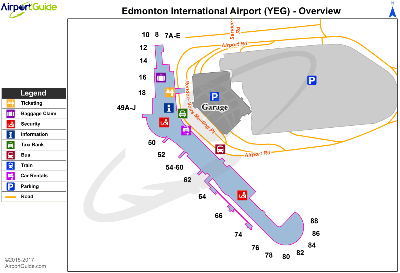
Maps & Diagrams
YEG Sectional
Flight Planning
at skyvector.com
at skyvector.com
