Location
Latitude: |
45-18-23.3552N (45.306488) |
Longitude: |
091-38-12.5629W (-91.636823) |
Elevation: |
1056.0 feet MSL (322 m MSL) |
Magnetic Variation: |
1.4 W (as of April 2024 from WMM2020 model) |
Time Zone: |
UTC -6.0 (Standard Time) UTC -5.0 (Daylight Savings Time) |
From City: |
01 N.M. SE of Chetek, Wisconsin |
Found On: |
Green Bay Chart |
FAA Region: |
AGL |
Contacts
Manager: |
Publicly owned: |
| DAN KNAPP P O BOX 194 CHETEK, WI 54728 (715) 642-0822 |
CITY OF CHETEK 220 STOUT ST CHETEK, WI 54728 715-924-4838 |
Operations
Airport Status: |
Operational |
Facility Use: |
Public |
Type: |
Airport |
Activation Date: |
10/1945 |
Control tower: |
No |
Attendance (Months/Days/Hours): |
Months/Days/Hours Unattended |
Boundary ARTCC: |
ZMP (Minneapolis) |
Responsible ARTCC: |
ZMP (Minneapolis) |
Lighting Schedule: |
SEE RMK |
Segmented Circle Indicator: |
Yes |
Traffic Pattern Altitude (MSL): |
2056 feet (627 m) |
NOTAMs Facility: |
GRB |
NOTAM-D Service: |
Yes |
Based Aircraft
| Single Engine: | 37 |
| Multi Engine: | 6 |
| Ultralights: | 4 |
Annual Operations (as of 07/03/2023)
| Total Operations: | 7240 | |
| Air Taxi: | 40 | 0.6% |
| GA Local: | 4800 | 66.3% |
| GA Itinerant: | 2400 | 33.1% |
Communications
| CTAF: | 122.900 |
| AWOS-3P: | 119.05 (715-924-1836) |
- APCH/DEP SVC PRVDD BY MINNEAPOLIS ARTCC ON FREQS 125.3/335.6 (EAU CLAIRE RCAG).
Fixed Based Operators (FBOs) & Fuel
(Click on a business for detail)
Please help us keep this information up to date. This is a FREE SERVICE just like everything else on Airport Guide! If you see that a business needs to be added, modified, or deleted please fill out our Update Form.
To add, modify, or delete a business click here.
Please help us keep this information up to date. This is a FREE SERVICE just like everything else on Airport Guide! If you see that a business needs to be added, modified, or deleted please fill out our Update Form.
Area Code: 715 |
| Business Name | Frequency | Phone | Fuel Grade |
|---|---|---|---|
| Chetek Municipal-Southworth Airport
Update FBO info |
924-4838 | 80, 100LL |
Flight Service Stations
| Primary | Alternate | |
| FSS on Field: | N | |
| FSS Name (ID): | Green Bay(GRB) | |
| Frequency: | ||
| Toll Free Phone: | 1-800-WX-BRIEF |
Instrument Procedures / Charts
FAA Terminal Procedures valid from 0901Z 03/21/24 to 0901Z 04/18/24.
There are various types of charts available for an airport. They are listed in the Page Type column. Here is a legend for those types:
APD - Airport Diagram
DP - Departure Procedure Charts
HOT - Hot Spots
IAP - Instrument Approach Procedure Charts
MIN - Minimums
STAR - Standard Terminal Arrival Charts
| Page Type | Page Name | Volume | Action Since Last Cycle |
|---|---|---|---|
| IAP | RNAV (GPS) RWY 17 | EC-3 | |
| IAP | RNAV (GPS) RWY 35 | EC-3 | |
| MIN | ALTERNATE MINIMUMS | EC-3 | |
| MIN | TAKEOFF MINIMUMS | EC-3 |
Terminal Procedures are only available for airports in several countries with more being added all the time. If you are looking for a specific country's charts, please send an email to support(at)airportguide.com stating the country name. This will be used to prioritize the implementation.
Navigation Aids (Navaids) near Y23
| Dist (NM) | ID | Morse Code | Name | Type | Freq | True Hdg | Mag Hdg |
|---|---|---|---|---|---|---|---|
| 7.0 | RP | . _ . . _ _ . | Wickr | NDB | 221 | 275 | 276 |
| 8.8 | RPD | . _ . . _ _ . _ . . | Rice Lake | VOR-DME | 110.00 | 317 | 318 |
| 24.4 | EA | . . _ | Maggs | NDB | 239 | 152 | 154 |
| 25.4 | EAU | . . _ . . _ | Eau Claire | VORTAC | 113.65 | 164 | 165 |
| 29.2 | RCX | . _ . _ . _ . _ . . _ | Rusk County | NDB | 356 | 66 | 68 |
| 43.5 | HYR | . . . . _ . _ _ . _ . | Hayward | DME | 113.4 | 10 | 12 |
| 43.5 | BXR | _ . . . _ . . _ . _ . | Big Doctor | NDB | 203 | 315 | 316 |
| 43.7 | RZN | . _ . _ _ . . _ . | Siren | DME | 109.4 | 315 | 316 |
| 56.7 | PBH | . _ _ . _ . . . . . . . | Phillips | NDB | 263 | 64 | 66 |
| 57.4 | MDZ | _ _ _ . . _ _ . . | Medford | NDB | 335 | 101 | 103 |
| 60.1 | ROS | . _ . _ _ _ . . . | Rush City | NDB | 282 | 293 | 294 |
| 60.4 | RG | . _ . _ _ . | Regue | NDB | 274 | 225 | 226 |
| 61.1 | PPI | . _ _ . . _ _ . . . | Hopey | NDB | 400 | 245 | 246 |
| 63.1 | BA | _ . . . . _ | Babco | NDB | 385 | 245 | 246 |
| 63.9 | PKF | . _ _ . _ . _ . . _ . | Park Falls | NDB | 371 | 52 | 54 |
| 64.1 | STP | . . . _ . _ _ . | St Paul | VOT | 114.40 | 250 | 251 |
| 65.5 | VIQ | . . . _ . . _ _ . _ | Neillsville | NDB | 368 | 132 | 134 |
| 68.1 | MS | _ _ . . . | Narco | NDB | 266 | 245 | 246 |
| 70.1 | CBG | _ . _ . _ . . . _ _ . | Cambridge | NDB | 350 | 282 | 283 |
| 71.5 | BCK | _ . . . _ . _ . _ . _ | Black River Falls | NDB | 362 | 151 | 153 |
Nearby Airports with Fuel
Notices to Airmen (NOTAMS)
Remarks
| A110-3 | RY 17/35 MAY NOT BE PLOWED FOR 24 HRS AFT HVY SNOWFALL OR DRIFTING SNOW. |
| A110-5 | RY 07/25 NOT PLOWED FOR SNOW, OPEN TO SKI EQUIPED AIRCRAFT. |
| A110-6 | FOR CD CTC MINNEAPOLIS ARTCC AT 651-463-5588. |
| A42-07 | MKD WITH YELLOW CONES. |
| A42-25 | MKD WITH YELLOW CONES. |
| A57-07 | APCH RATIO 13:1 TO DSPLCD THR, 75 FT TREES 1026 FT FM DSPLCD THR, 175 FT R; APCH RATIO 13:1 TO DSPLCD THR, 90 FT TREES 1200 FT FM DSPLCD THR, 225 FT L. |
| A57-17 | APCH RATIO 20:1 TO DSPLCD THR. |
| A58-17 | HANGAR 200 FT LEFT. |
| A70-FUEL-10 | 0LL 24 HR SELF SVC FUEL AVBL WITH CREDIT CARD. |
| A81-APT | MIRL RWY 17/35 PRESET ON LOW SS-SR; TO INCR INTST & ACTVT REIL RWY 17 & 35; PAPI RWY 17 & 35; MIRL RWY 17/35 - CTAF. |
Runways
Runway Summary
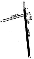
| Runways: | 07/25 17/35 |
| Longest Runway: | 17/35 is 3401 ft (1037 m) long |
| Runways with an Instrument Approach: |
Y23 Airport Runway Details
| Runway 07/25 | 1490 ft x 120 ft (454 m x 37 m) | |
| Runway Length Source: | FAA OE/AAA as of 03/28/2014 | |
| Surface: | Turf - Fair condition - No special surface treatment | |
Runway 07 |
Runway 25 |
|
Elevation: |
1047.8 | 1052.9 |
Latitude: |
45-18-28.6536N | 45-18-32.4900N |
Longitude: |
091-38-34.0100W | 091-38-13.8800W |
|
Runway True Alignment: |
075 | 255 |
Glide Path Angle: |
0.0 degrees | 0.0 degrees |
Traffic Pattern: |
Left | Left |
Runway Markings Type: |
None | None |
Object at End: |
TREES | TREES |
Object Height: |
75 | 90 |
Distance from End: |
835 | 1000 |
Object Centerline Offset: |
175 ft. right of centerline | 225 ft. left of centerline |
REIL: |
No | No |
Touchdown Lights: |
No | No |
Centerline Lights: |
No | No |
Threshold Elevation: |
1047.4 | 1051.4 |
Displaced Threshold: |
191 | 200 |
Threshold Latitude: |
45-18-29.1439N | 45-18-31.9756N |
Threshold Longitude: |
091-38-31.4325W | 091-38-16.5813W |
| Runway 17/35 | 3401 ft x 60 ft (1037 m x 18 m) | |
| Runway Length Source: | 3RD PARTY SURVEY as of 07/17/2010 | |
| Surface: | Turf - Fair condition - No special surface treatment | |
| Runway Edge Lights: | Medium Intensity | |
Runway 17 |
Runway 35 |
|
Elevation: |
1054.9 | 1055.3 |
Latitude: |
45-18-36.9129N | 45-18-03.4742N |
Longitude: |
091-38-09.7630W | 091-38-05.3896W |
|
Runway True Alignment: |
175 | 355 |
Glide Path Angle: |
4.0 degrees | 3.0 degrees |
Traffic Pattern: |
Left | Left |
Runway Markings Type: |
Nonprecision Instrument | Nonprecision Instrument |
Runway Markings Condition: |
Good | Good |
Object at End: |
TREE | ROAD |
Object Height: |
38 | 13 |
Object Marked/Lighted?: |
Lighted | Lighted |
Distance from End: |
540 | 370 |
Object Centerline Offset: |
175 ft. right of centerline | 225 ft. left of centerline |
Visual Glide Slope Indicators: |
2-Light PAPI On Left Side Of Runway | 2-Light PAPI On Left Side Of Runway |
REIL: |
Yes | Yes |
Touchdown Lights: |
No | No |
Centerline Lights: |
No | No |
Threshold Crossing Height: |
22 | 16 |
Threshold Elevation: |
1055.8 | |
Displaced Threshold: |
600 | |
Threshold Latitude: |
45-18-31.0130N | |
Threshold Longitude: |
091-38-08.9915W |
Services
Airframe Repair: |
Major |
Powerplant Repair: |
Minor |
Bottled Oxygen: |
None |
Bulk Oxygen: |
None |
Fuel Available: |
100LL, Jet A, UL94 |
Landing Fees: |
No |
Parking: |
Hangars and tiedowns available |
Maps & Diagrams
Y23 Sectional
Flight Planning
at skyvector.com
at skyvector.com