Location
Latitude: |
29-21-16.5780N (29.354605) |
Longitude: |
082-28-14.0290W (-82.470564) |
Elevation: |
75.6 feet MSL (23 m MSL) |
Magnetic Variation: |
6.2 W (as of April 2024 from WMM2020 model) |
Time Zone: |
UTC -5.0 (Standard Time) UTC -4.0 (Daylight Savings Time) |
From City: |
02 N.M. SW of Williston, Florida |
Found On: |
Jacksonville Chart |
FAA Region: |
ASO |
Contacts
Manager: |
Publicly owned: |
| BENTON STEGALL PO BOX 160 WILLISTON, FL 32696-0160 352-528-4900 |
CITY OF WILLISTON PO BOX 160 WILLISTON, FL 32696 352-528-4900 |
Operations
Airport Status: |
Operational |
Facility Use: |
Public |
Type: |
Airport |
Activation Date: |
02/1944 |
Control tower: |
No |
Attendance (Months/Days/Hours): |
Months/Days/Hours ALL/ALL/0730-1730 |
Boundary ARTCC: |
ZJX (Jacksonville) |
Responsible ARTCC: |
ZJX (Jacksonville) |
Lighting Schedule: |
SEE RMK |
Segmented Circle Indicator: |
Yes |
Traffic Pattern Altitude (MSL): |
1076 feet (328 m) |
NOTAMs Facility: |
GNV |
NOTAM-D Service: |
Yes |
International Airport of Entry: |
No |
Customs Landing Rights: |
No |
Military Landing Rights: |
Yes |
Civil/Military Joint Use: |
No |
Based Aircraft
| Single Engine: | 61 |
| Multi Engine: | 14 |
| Jet Engine: | 25 |
| GA Helicopters: | 3 |
Annual Operations (as of 09/21/2018)
| Total Operations: | 16250 | |
| GA Local: | 4950 | 30.5% |
| GA Itinerant: | 11300 | 69.5% |
Communications
| CTAF: | 122.975 |
| Unicom: | 122.975 |
| Approach: | JACKSONVILLE 118.6 118.6 |
| Departure: | JACKSONVILLE 118.6 118.6 |
| AWOS-3T: | 118.425 (352-528-9949) |
Fixed Based Operators (FBOs) & Fuel
(Click on a business for detail)
Please help us keep this information up to date. This is a FREE SERVICE just like everything else on Airport Guide! If you see that a business needs to be added, modified, or deleted please fill out our Update Form.
To add, modify, or delete a business click here.
Please help us keep this information up to date. This is a FREE SERVICE just like everything else on Airport Guide! If you see that a business needs to be added, modified, or deleted please fill out our Update Form.
Area Code: 352 |
| Business Name | Frequency | Phone | Fuel Grade |
|---|
Flight Service Stations
| Primary | Alternate | |
| FSS on Field: | N | |
| FSS Name (ID): | Gainesville(GNV) | |
| Frequency: | ||
| Toll Free Phone: | 1-800-WX-BRIEF |
Instrument Procedures / Charts
FAA Terminal Procedures valid from 0901Z 03/21/24 to 0901Z 04/18/24.
There are various types of charts available for an airport. They are listed in the Page Type column. Here is a legend for those types:
APD - Airport Diagram
DP - Departure Procedure Charts
HOT - Hot Spots
IAP - Instrument Approach Procedure Charts
MIN - Minimums
STAR - Standard Terminal Arrival Charts
| Page Type | Page Name | Volume | Action Since Last Cycle |
|---|---|---|---|
| IAP | RNAV (GPS) RWY 05 | SE-3 | |
| IAP | RNAV (GPS) RWY 23 | SE-3 | |
| MIN | TAKEOFF MINIMUMS | SE-3 |
Terminal Procedures are only available for airports in several countries with more being added all the time. If you are looking for a specific country's charts, please send an email to support(at)airportguide.com stating the country name. This will be used to prioritize the implementation.
Navigation Aids (Navaids) near X60
| Dist (NM) | ID | Morse Code | Name | Type | Freq | True Hdg | Mag Hdg |
|---|---|---|---|---|---|---|---|
| 16.6 | OCF | _ _ _ _ . _ . . . _ . | Ocala | VORTAC | 113.70 | 129 | 135 |
| 22.7 | GNV | _ _ . _ . . . . _ | Gators | VORTAC | 116.20 | 26 | 32 |
| 24.5 | GN | _ _ . _ . | Wynds | NDB | 269 | 39 | 45 |
| 33.6 | CTY | _ . _ . _ _ . _ _ | Cross City | VORTAC | 112.00 | 296 | 302 |
| 38.8 | IAK | . . . _ _ . _ | Palatka | NDB | 243 | 62 | 68 |
| 47.4 | LEE | . _ . . . . | Leesburg | NDB | 335 | 132 | 138 |
| 50.2 | LCQ | . _ . . _ . _ . _ _ . _ | Lake City | NDB | 204 | 353 | 359 |
| 56.1 | RYD | . _ . _ . _ _ _ . . | Reynolds | NDB | 338 | 48 | 55 |
| 59.7 | VQQ | . . . _ _ _ . _ _ _ . _ | Cecil | VOR | 117.90 | 30 | 36 |
| 65.0 | DED | _ . . . _ . . | Deland/Dcmsnd | NDB | 201 | 105 | 112 |
| 67.1 | NIP | _ . . . . _ _ . | Jacksonville | TACAN | 108.20 | 37 | 44 |
| 69.1 | TAY | _ . _ _ . _ _ | Taylor | VORTAC | 112.90 | 356 | 362 |
| 69.6 | SGJ | . . . _ _ . . _ _ _ | St Augustine | VOR-DME | 109.40 | 58 | 65 |
| 69.6 | RHZ | . _ . . . . . _ _ . . | Zephyrhills | NDB | 253 | 166 | 172 |
| 71.1 | OMN | _ _ _ _ _ _ . | Ormond Beach | VORTAC | 112.60 | 92 | 99 |
| 72.9 | SFB | . . . . . _ . _ . . . | Sanford | NDB | 408 | 117 | 124 |
| 74.5 | OR | _ _ _ . _ . | Herny | NDB | 221 | 132 | 139 |
| 74.8 | DAB | _ . . . _ _ . . . | Daytona Beach | VOT | 111.00 | 97 | 104 |
| 75.2 | JA | . _ _ _ . _ | Dinns | NDB | 344 | 27 | 34 |
| 76.2 | TP | _ . _ _ . | Cosme | NDB | 368 | 182 | 188 |
Nearby Airports with Fuel
Notices to Airmen (NOTAMS)
Remarks
| A110-1 | INFIELD BERM & TREES BLOCKING VISION BTN RWY ENDS. |
| A110-2 | FOR CD CTC JACKSONVILLE APCH AT 904-741-0284. |
| A81-APT | ACTVT REIL RWY 05, 14, 23 & 32; HIRL RWY 05/23; MIRL RWY 14/32. - CTAF. |
| E111 | EXISTED PRIOR TO 1959. |
Runways
Runway Summary
| Runways: | 05/23 14/32 18/36 |
| Longest Runway: | 05/23 is 6669 ft (2033 m) long |
| Runways with an Instrument Approach: |
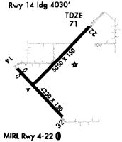
X60 Airport Runway Details
| Runway 05/23 | 6669 ft x 100 ft (2033 m x 30 m) | |
| Runway Length Source: | 3RD PARTY SURVEY as of 10/09/2010 | |
| Surface: | Concrete - Good condition - Saw-cut or plastic grooved | |
| Runway Pavement Class: | 15 /R/B/X/T | |
| Runway Edge Lights: | High Intensity | |
Runway Weight Bearing Capacity (in thousands of pounds) |
||
| Single Wheel Landing Gear: | 72.0 | |
| Dual Wheel Landing Gear: | 95.0 | |
| Dual Tandem Wheel Landing Gear: | 160.0 | |
Runway 05 |
Runway 23 |
|
Elevation: |
73.0 | 75.6 |
Latitude: |
29-21-09.2411N | 29-21-56.0005N |
Longitude: |
082-28-35.5779W | 082-27-42.3772W |
|
Runway True Alignment: |
045 | 225 |
Glide Path Angle: |
3.0 degrees | 3.0 degrees |
Traffic Pattern: |
Left | Left |
Runway Markings Type: |
Nonprecision Instrument | Nonprecision Instrument |
Runway Markings Condition: |
Fair | Fair |
Object at End: |
TREES | TREES |
Object Height: |
46 | 48 |
Distance from End: |
1785 | 1920 |
Object Centerline Offset: |
180 ft. left of centerline | 240 ft. right of centerline |
Visual Glide Slope Indicators: |
2-Light PAPI On Left Side Of Runway | 2-Light PAPI On Left Side Of Runway |
REIL: |
Yes | Yes |
Threshold Crossing Height: |
38 | 35 |
| Runway 14/32 | 4979 ft x 60 ft (1518 m x 18 m) | |
| Runway Length Source: | 3RD PARTY SURVEY as of 10/09/2010 | |
| Surface: | Concrete - Good condition - No special surface treatment | |
| Runway Pavement Class: | 18 /R/A/W/T | |
| Runway Edge Lights: | Medium Intensity | |
Runway Weight Bearing Capacity (in thousands of pounds) |
||
| Single Wheel Landing Gear: | 38.0 | |
Runway 14 |
Runway 32 |
|
Elevation: |
66.8 | 64.0 |
Latitude: |
29-21-20.6300N | 29-20-43.7300N |
Longitude: |
082-28-50.4700W | 082-28-13.1700W |
|
Runway True Alignment: |
138 | 318 |
Glide Path Angle: |
3.0 degrees | 3.0 degrees |
Traffic Pattern: |
Left | Left |
Runway Markings Type: |
Basic | Basic |
Runway Markings Condition: |
Fair | Fair |
Object at End: |
TREES | TREES |
Object Height: |
81 | 43 |
Distance from End: |
1885 | 1060 |
Object Centerline Offset: |
180 ft. left of centerline | 240 ft. right of centerline |
Visual Glide Slope Indicators: |
2-Light PAPI On Left Side Of Runway | 2-Light PAPI On Left Side Of Runway |
REIL: |
Yes | Yes |
Threshold Crossing Height: |
42 | 44 |
| Runway 18/36 | 2051 ft x 60 ft (625 m x 18 m) | |
| Runway Length Source: | OWNER as of 03/18/2020 | |
| Surface: | Concrete - Good condition - No special surface treatment | |
Runway 18 |
Runway 36 |
|
Elevation: |
65.0 | 66.0 |
Latitude: |
29-21-09.5200N | 29-20-49.2100N |
Longitude: |
082-27-47.2700W | 082-27-47.2700W |
|
Runway True Alignment: |
180 | 360 |
Glide Path Angle: |
0.0 degrees | 0.0 degrees |
Traffic Pattern: |
Right | |
Runway Markings Type: |
None | None |
Runway Markings Condition: |
Fair | Fair |
Object at End: |
TREES | TREES |
Object Height: |
88 | 66 |
Distance from End: |
3050 | 1505 |
Object Centerline Offset: |
180 ft. left of centerline | 240 ft. right of centerline |
Services
Airframe Repair: |
Major |
Powerplant Repair: |
Major |
Bottled Oxygen: |
None |
Bulk Oxygen: |
None |
Fuel Available: |
100LL, Jet A |
Landing Fees: |
No |
Parking: |
Hangars and tiedowns available |
Maps & Diagrams
X60 Sectional
Flight Planning
at skyvector.com
at skyvector.com