Location
Latitude: |
38-22-41.6000N (38.378222) |
Longitude: |
121-57-40.3000W (-121.961194) |
Elevation: |
116.9 feet MSL (36 m MSL) |
Magnetic Variation: |
13.1 E (as of April 2024 from WMM2020 model) |
Time Zone: |
UTC -8.0 (Standard Time) UTC -7.0 (Daylight Savings Time) |
From City: |
02 N.M. NE of Vacaville, California |
Found On: |
San Francisco Chart |
FAA Region: |
AWP |
Contacts
Manager: |
Publicly owned: |
| CATHERINE MCKENZIE COOK 301 COUNTY AIRPORT ROAD, SUITE 205 VACAVILLE, CA 95688 707-469-4603 |
COUNTY OF SOLANO 675 TEXAS ST FAIRFIELD, CA 94533 707-784-6100 |
Operations
Airport Status: |
Operational |
Facility Use: |
Public |
Type: |
Airport |
Control tower: |
No |
Attendance (Months/Days/Hours): |
Months/Days/Hours ALL/MON-FRI/1400-0100Z++ |
Boundary ARTCC: |
ZOA (Oakland) |
Responsible ARTCC: |
ZOA (Oakland) |
Lighting Schedule: |
SEE RMK |
Segmented Circle Indicator: |
Yes |
Traffic Pattern Altitude (MSL): |
1117 feet (340 m) |
NOTAMs Facility: |
VCB |
NOTAM-D Service: |
Yes |
International Airport of Entry: |
No |
Customs Landing Rights: |
No |
Military Landing Rights: |
Yes |
Civil/Military Joint Use: |
No |
Based Aircraft
| Single Engine: | 192 |
| Multi Engine: | 16 |
| GA Helicopters: | 7 |
Annual Operations (as of 01/04/2024)
| Total Operations: | 87000 | |
| Air Taxi: | 2000 | 2.3% |
| GA Local: | 35000 | 40.2% |
| GA Itinerant: | 50000 | 57.5% |
Communications
| CTAF: | 122.850 |
| Approach: | TRAVIS 128.4 128.4 |
| Departure: | TRAVIS 128.4 128.4 |
| ASOS: | 134.75 (707-448-1594) |
Fixed Based Operators (FBOs) & Fuel
(Click on a business for detail)
Please help us keep this information up to date. This is a FREE SERVICE just like everything else on Airport Guide! If you see that a business needs to be added, modified, or deleted please fill out our Update Form.
To add, modify, or delete a business click here.
Please help us keep this information up to date. This is a FREE SERVICE just like everything else on Airport Guide! If you see that a business needs to be added, modified, or deleted please fill out our Update Form.
Area Code: 707 |
| Business Name | Frequency | Phone | Fuel Grade |
|---|---|---|---|
| Airport Management
Update FBO info |
446-0322 | 100LL, Jet A | |
| Blue Ridge Aeronautics
Update FBO info |
Unicom 122.7 | 451-4400 |
Flight Service Stations
| Primary | Alternate | |
| FSS on Field: | N | |
| FSS Name (ID): | Rancho Murieta(RIU) | |
| Frequency: | ||
| Toll Free Phone: | 1-800-WX-BRIEF |
Instrument Procedures / Charts
FAA Terminal Procedures valid from 0901Z 03/21/24 to 0901Z 04/18/24.
There are various types of charts available for an airport. They are listed in the Page Type column. Here is a legend for those types:
APD - Airport Diagram
DP - Departure Procedure Charts
HOT - Hot Spots
IAP - Instrument Approach Procedure Charts
MIN - Minimums
STAR - Standard Terminal Arrival Charts
| Page Type | Page Name | Volume | Action Since Last Cycle |
|---|---|---|---|
| DP | SOKOY THREE | SW-2 | |
| IAP | RNAV (GPS) RWY 20 | SW-2 | |
| IAP | VOR-A | SW-2 | |
| MIN | ALTERNATE MINIMUMS | SW-2 | |
| MIN | TAKEOFF MINIMUMS | SW-2 |
Terminal Procedures are only available for airports in several countries with more being added all the time. If you are looking for a specific country's charts, please send an email to support(at)airportguide.com stating the country name. This will be used to prioritize the implementation.
Navigation Aids (Navaids) near VCB
| Dist (NM) | ID | Morse Code | Name | Type | Freq | True Hdg | Mag Hdg |
|---|---|---|---|---|---|---|---|
| 7.4 | TZZ | _ _ _ . . _ _ . . | Travis | VOR | 116.40 | 106 | 93 |
| 8.0 | SUU | . . . . . _ . . _ | Travis | TACAN | 116.60 | 174 | 161 |
| 19.6 | SAC | . . . . _ _ . _ . | Sacramento | VORTAC | 115.20 | 78 | 65 |
| 20.2 | CC | _ . _ . _ . _ . | Kanan | NDB | 335 | 189 | 176 |
| 20.4 | CCR | _ . _ . _ . _ . . _ . | Concord | VOR-DME | 117.00 | 191 | 178 |
| 22.8 | SGD | . . . _ _ . _ . . | Scaggs Island | VORTAC | 112.10 | 238 | 225 |
| 23.3 | SAC | . . . . _ _ . _ . | Sacramento Executive | VOT | 111.40 | 70 | 57 |
| 25.6 | SMF | . . . _ _ . . _ . | Sacramento Intl | VOT | 111.40 | 42 | 29 |
| 31.4 | MCC | _ _ _ . _ . _ . _ . | Mc Clellan | VOR-DME | 109.20 | 56 | 43 |
| 40.7 | STS | . . . _ . . . | Santa Rosa | DME | 116.15 | 281 | 268 |
| 41.1 | OAK | _ _ _ . _ _ . _ | Oakland | VOR-DME | 116.80 | 197 | 184 |
| 41.1 | SAU | . . . . _ . . _ | Sausalito | VOR-DME | 116.20 | 220 | 207 |
| 41.7 | ILA | . . . _ . . . _ | Williams | VORTAC | 114.40 | 355 | 342 |
| 43.2 | LV | . _ . . . . . _ | Reiga | NDB | 374 | 162 | 149 |
| 46.3 | PYE | . _ _ . _ . _ _ . | Point Reyes | VOR-DME | 113.70 | 247 | 234 |
| 46.9 | MYV | _ _ _ . _ _ . . . _ | Marysville | VOR-DME | 110.80 | 22 | 9 |
| 47.8 | TCY | _ _ . _ . _ . _ _ | Tracy | NDB | 203 | 149 | 136 |
| 48.7 | LIN | . _ . . . . _ . | Linden | VOR-DME | 114.80 | 111 | 98 |
| 49.3 | SFO | . . . . . _ . _ _ _ | San Francisco | VOT | 111.00 | 202 | 189 |
| 49.5 | SFO | . . . . . _ . _ _ _ | San Francisco | VOR-DME | 115.80 | 203 | 190 |
Nearby Airports with Fuel
Notices to Airmen (NOTAMS)
Remarks
| A110-2 | NO TURNS TO XW BLW 800 FT MSL; RMN W OF INSTA HWY FOR RWY 20, NOISE SENSITIVE AREA W OF ARPT. |
| A110-3 | TWY LGTS ON PARL TWY ONLY. |
| A110-4 | RWY 02 CALM WIND RWY. |
| A110-5 | FOR CD CTC OAKLAND ARTCC AT 510-745-3380. |
| A81-APT | AFT 2200 ACTVT MIRL & PARALLEL TWY LGTS RY 02/20; PAPI & REIL RYS 02 & 20 - CTAF. |
| A90 | INCLUDES 2 GYROPLANES. |
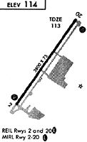
Runways
Runway Summary
| Runways: | 02/20 |
| Longest Runway: | 02/20 is 4700 ft (1433 m) long |
| Runways with an Instrument Approach: |
VCB Airport Runway Details
| Runway 02/20 | 4700 ft x 75 ft (1433 m x 23 m) | |
| Runway Length Source: | 3RD PARTY SURVEY as of 07/07/2015 | |
| Surface: | Asphalt - Good condition - No special surface treatment | |
| Runway Edge Lights: | Medium Intensity | |
Runway Weight Bearing Capacity (in thousands of pounds) |
||
| Single Wheel Landing Gear: | 30.0 | |
Runway 02 |
Runway 20 |
|
Elevation: |
115.8 | 111.7 |
Latitude: |
38-22-22.3247N | 38-23-00.9631N |
Longitude: |
121-57-56.7113W | 121-57-23.9357W |
|
Runway True Alignment: |
034 | 214 |
Glide Path Angle: |
3.8 degrees | 3.8 degrees |
Traffic Pattern: |
Left | Right |
Runway Markings Type: |
Nonprecision Instrument | Nonprecision Instrument |
Runway Markings Condition: |
Good | Good |
Object at End: |
TREE | |
Object Height: |
52 | |
Distance from End: |
1450 | |
Object Centerline Offset: |
200 ft. right of centerline | |
Visual Glide Slope Indicators: |
2-Light PAPI On Left Side Of Runway | 2-Light PAPI On Left Side Of Runway |
REIL: |
Yes | Yes |
Touchdown Lights: |
No | No |
Centerline Lights: |
No | No |
Threshold Crossing Height: |
27 | 27 |
Services
Airframe Repair: |
None |
Powerplant Repair: |
None |
Bottled Oxygen: |
None |
Bulk Oxygen: |
None |
Fuel Available: |
100LL, Jet A |
Landing Fees: |
Yes |
Parking: |
Hangars and tiedowns available |
Maps & Diagrams
VCB Sectional
Flight Planning
at skyvector.com
at skyvector.com