Location
Latitude: |
44-35-29.6810N (44.591578) |
Longitude: |
114-49-23.3160W (-114.823143) |
Elevation: |
5500.0 feet MSL (1676 m MSL) |
Magnetic Variation: |
12.6 E (as of April 2024 from WMM2020 model) |
Time Zone: |
UTC -7.0 (Standard Time) UTC -6.0 (Daylight Savings Time) |
From City: |
26 N.M. NW of Challis, Idaho |
Found On: |
Great Falls Chart |
FAA Region: |
ANM |
Contacts
Manager: |
Publicly owned: |
| MIDDLE FORK DIST RANGER P.O. BOX 750 HIGHWAY 93 CHALLIS, ID 83226 208-879-4101 |
U.S. FOREST SERVICE 324 25TH ST OGDEN, UT 84401 208-625-5511 |
Operations
Airport Status: |
Operational |
Facility Use: |
Public |
Type: |
Airport |
Activation Date: |
07/1958 |
Control tower: |
No |
Attendance (Months/Days/Hours): |
Months/Days/Hours Unattended |
Boundary ARTCC: |
ZLC (Salt Lake City) |
Responsible ARTCC: |
ZLC (Salt Lake City) |
Segmented Circle Indicator: |
Yes |
Traffic Pattern Altitude (MSL): |
6500 feet (1981 m) |
NOTAMs Facility: |
BOI |
NOTAM-D Service: |
Yes |
Military Landing Rights: |
No |
Civil/Military Joint Use: |
No |
Based Aircraft
Annual Operations (as of 06/30/2021)
| Total Operations: | 800 | |
| Air Taxi: | 300 | 37.5% |
| GA Itinerant: | 500 | 62.5% |
Communications
| CTAF: | 122.900 |
Fixed Based Operators (FBOs) & Fuel
(Click on a business for detail)
Please help us keep this information up to date. This is a FREE SERVICE just like everything else on Airport Guide! If you see that a business needs to be added, modified, or deleted please fill out our Update Form.
To add, modify, or delete a business click here.
Please help us keep this information up to date. This is a FREE SERVICE just like everything else on Airport Guide! If you see that a business needs to be added, modified, or deleted please fill out our Update Form.
Area Code: 208 |
| Business Name | Frequency | Phone | Fuel Grade |
|---|
Flight Service Stations
| Primary | Alternate | |
| FSS on Field: | N | |
| FSS Name (ID): | Boise(BOI) | |
| Frequency: | ||
| Toll Free Phone: | 1-800-WX-BRIEF |
Instrument Procedures / Charts
Terminal Procedures are only available for airports in several countries with more being added all the time. If you are looking for a specific country's charts, please send an email to support(at)airportguide.com stating the country name. This will be used to prioritize the implementation.
Navigation Aids (Navaids) near U72
| Dist (NM) | ID | Morse Code | Name | Type | Freq | True Hdg | Mag Hdg |
|---|---|---|---|---|---|---|---|
| 40.7 | LKT | . _ . . _ . _ _ | Salmon | VOR-DME | 113.50 | 50 | 38 |
| 59.9 | DNJ | _ . . _ . . _ _ _ | Donnelly | VOR-DME | 116.20 | 280 | 267 |
| 79.7 | HLE | . . . . . _ . . . | Hailey | NDB-DME | 220 | 161 | 149 |
| 85.8 | BOI | _ . . . _ _ _ . . | Boise | VORTAC | 113.30 | 223 | 210 |
| 86.5 | BOI | _ . . . _ _ _ . . | Boise | VOT | 116.70 | 224 | 211 |
| 87.7 | BO | _ . . . _ _ _ | Ustik | NDB | 359 | 227 | 214 |
| 94.8 | MPA | _ _ . _ _ . . _ | Meridian | NDB | 238 | 231 | 218 |
| 95.8 | STI | . . . _ . . | Sturgeon | NDB | 333 | 202 | 189 |
| 99.9 | ONO | _ _ _ _ . _ _ _ | Ontario | NDB | 305 | 250 | 237 |
Nearby Airports with Fuel
| Dist (NM) | Name (Airport IDs) | True Hdg | Mag Hdg | Fuel Grade |
|---|---|---|---|---|
| 23.5 | Stanley Airport (2U7) |
191 | 178 | 100LL |
| 26.2 | Challis Airport (CHL KLLJ LLJ) |
98 | 86 | 100, Jet A |
| 51.2 | Lemhi County Airport (SMN KSMN SMN) |
51 | 39 | 100, Jet A |
| 51.3 | Cascade Airport (U70) |
263 | 250 | 100LL, Jet A |
| 57.3 | Mc Call Municipal Airport (MYL KMYL MYL) |
288 | 275 | 100LL, Jet A, Jet A-1+ |
| 69.1 | Friedman Meml Airport (SUN KSUN SUN) |
160 | 148 | 100LL, Jet A-1+ |
| 69.9 | Council Municipal Airport (U82) |
278 | 265 | 100LL |
| 80.4 | West Fork Lodge Airport (4U7) |
18 | 5 | Mogas |
| 86.1 | Emmett Municipal Airport (S78) |
239 | 226 | 100LL |
| 86.2 | Boise Air Trml/Gowen Field Airport (BOI KBOI BOI) |
224 | 211 | 100LL, Jet A+ |
| 87.3 | Arco-Butte County Airport (KAOC AOC) |
132 | 120 | 100LL |
| 94.1 | Payette Municipal Airport (S75) |
252 | 239 | 100LL, MOGAS |
| 94.5 | Weiser Municipal Airport (S87) |
256 | 243 | 100LL |
| 95.1 | Nampa Municipal Airport (KMAN MAN) |
230 | 217 | 100LL, Jet A, MOGAS |
| 96.7 | Caldwell Exec Airport (EUL KEUL EUL) |
234 | 221 | 100LL, Jet A, Jet A+ |
| 97.9 | Idaho County Airport (KGIC GIC) |
326 | 313 | 100LL, Jet A |
Notices to Airmen (NOTAMS)
Remarks
| A110-1 | RECOMMENDED FOR EXPERIENCED MOUNTAIN PILOTS ONLY. |
| A110-2 | TREES AND HIGH TRRN ON BOTH ENDS OF RWY 04/22, REQUIRES A STEEP APCH. |
| A110-3 | NO WINTER MAINTENANCE. |
| A110-4 | RWY 04/22 NUMEROUS ADDITIONAL OBSTNS ON APCH TO BOTH RWY ENDS. |
| A110-5 | FOR CD CTC SALT LAKE ARTCC AT 801-320-2568. |
| A30-04/22 | RCMD LAND RWY 22; TKOF RWY 04 WHEN WIND CONDS PMT. |
| A42-04 | 04/22 EDGES & THRS MARKED WITH WHITE ROCKS. |
| E111 | EXISTED PRIOR TO 31 DEC 1958. |
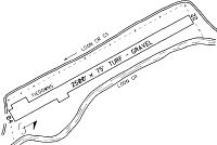
Runways
Runway Summary
| Runways: | 04/22 |
| Longest Runway: | 04/22 is 2500 ft (762 m) long |
| Runways with an Instrument Approach: |
U72 Airport Runway Details
| Runway 04/22 | 2500 ft x 75 ft (762 m x 23 m) | |
| Surface: | Turf/Dirt - Good condition - No special surface treatment | |
Runway 04 |
Runway 22 |
|
Glide Path Angle: |
0.0 degrees | 0.0 degrees |
Traffic Pattern: |
Left | Left |
Object at End: |
TREE | TREES |
Object Height: |
70 | 50 |
Distance from End: |
45 | 250 |
Object Centerline Offset: |
70 ft. left of centerline | 150 ft. left of centerline |
Services
Airframe Repair: |
Minor |
Powerplant Repair: |
Minor |
Bottled Oxygen: |
None |
Bulk Oxygen: |
None |
Fuel Available: |
100LL, Jet A |
Landing Fees: |
No |
Parking: |
Tiedowns available |
Maps & Diagrams
U72 Sectional
Flight Planning
at skyvector.com
at skyvector.com