Location
Latitude: |
45-48-54.1000N (45.815028) |
Longitude: |
097-44-34.1000W (-97.742806) |
Elevation: |
1318.4 feet MSL (402 m MSL) |
Magnetic Variation: |
3.4 E (as of April 2024 from WMM2020 model) |
Time Zone: |
UTC -6.0 (Standard Time) UTC -5.0 (Daylight Savings Time) |
From City: |
02 N.M. N of Britton, South Dakota |
Found On: |
Twin Cities Chart |
FAA Region: |
AGL |
Contacts
Manager: |
Publicly owned: |
| RYAN FURMAN PO BOX 941 BRITTON, SD 57430 (605) 470-0485 |
CITY OF BRITTON 803 8TH ST BRITTON, SD 57430 605-448-5721 |
Operations
Airport Status: |
Operational |
Facility Use: |
Public |
Type: |
Airport |
Activation Date: |
05/1946 |
Control tower: |
No |
Attendance (Months/Days/Hours): |
Months/Days/Hours ALL/MON-FRI/DALGT |
Boundary ARTCC: |
ZMP (Minneapolis) |
Responsible ARTCC: |
ZMP (Minneapolis) |
Lighting Schedule: |
SEE RMK |
Segmented Circle Indicator: |
No |
Traffic Pattern Altitude (MSL): |
2318 feet (707 m) |
NOTAMs Facility: |
HON |
NOTAM-D Service: |
Yes |
International Airport of Entry: |
No |
Customs Landing Rights: |
No |
Military Landing Rights: |
No |
Civil/Military Joint Use: |
No |
Based Aircraft
| Single Engine: | 8 |
| Multi Engine: | 2 |
Annual Operations (as of 04/28/2022)
| Total Operations: | 2240 | |
| GA Local: | 2000 | 89.3% |
| GA Itinerant: | 240 | 10.7% |
Communications
| CTAF: | 122.800 |
| Unicom: | 122.800 |
| AWOS-3P: | 118.275 (605-448-2110) |
- APCH/DEP SVC PRVDD BY MINNEAPOLIS ARTCC ON FREQS 120.6/371.9 (ABERDEEN RCAG).
Fixed Based Operators (FBOs) & Fuel
(Click on a business for detail)
Please help us keep this information up to date. This is a FREE SERVICE just like everything else on Airport Guide! If you see that a business needs to be added, modified, or deleted please fill out our Update Form.
To add, modify, or delete a business click here.
Please help us keep this information up to date. This is a FREE SERVICE just like everything else on Airport Guide! If you see that a business needs to be added, modified, or deleted please fill out our Update Form.
Area Code: 605 |
| Business Name | Frequency | Phone | Fuel Grade |
|---|---|---|---|
| Dakota Ag Service
Update FBO info |
Unicom 122.8 | 448-2264 | 100LL |
Flight Service Stations
| Primary | Alternate | |
| FSS on Field: | N | |
| FSS Name (ID): | Huron(HON) | |
| Frequency: | ||
| Toll Free Phone: | 1-800-WX-BRIEF |
Instrument Procedures / Charts
FAA Terminal Procedures valid from 0901Z 03/21/24 to 0901Z 04/18/24.
There are various types of charts available for an airport. They are listed in the Page Type column. Here is a legend for those types:
APD - Airport Diagram
DP - Departure Procedure Charts
HOT - Hot Spots
IAP - Instrument Approach Procedure Charts
MIN - Minimums
STAR - Standard Terminal Arrival Charts
| Page Type | Page Name | Volume | Action Since Last Cycle |
|---|---|---|---|
| IAP | RNAV (GPS) RWY 13 | NC-1 | |
| IAP | RNAV (GPS) RWY 31 | NC-1 | |
| MIN | ALTERNATE MINIMUMS | NC-1 | |
| MIN | TAKEOFF MINIMUMS | NC-1 |
Terminal Procedures are only available for airports in several countries with more being added all the time. If you are looking for a specific country's charts, please send an email to support(at)airportguide.com stating the country name. This will be used to prioritize the implementation.
Navigation Aids (Navaids) near TTO
| Dist (NM) | ID | Morse Code | Name | Type | Freq | True Hdg | Mag Hdg |
|---|---|---|---|---|---|---|---|
| 24.9 | GWR | _ _ . . _ _ . _ . | Gwinner | NDB | 278 | 9 | 6 |
| 35.5 | ABR | . _ _ . . . . _ . | Aberdeen | VOR-DME | 113.00 | 227 | 223 |
| 35.6 | AB | . _ _ . . . | Reney | NDB | 203 | 223 | 219 |
| 50.1 | ETH | . _ . . . . | Wheaton | NDB | 326 | 91 | 88 |
| 54.0 | BWP | _ . . . . _ _ . _ _ . | Breckenridge-Wahpeton | NDB | 233 | 61 | 58 |
| 56.2 | ATY | . _ _ _ . _ _ | Watertown | TACAN | 116.60 | 152 | 149 |
| 63.5 | VVV | . . . _ . . . _ . . . _ | Ortonville | NDB | 332 | 118 | 115 |
| 65.7 | AT | . _ _ | Lican | NDB | 215 | 157 | 154 |
| 67.3 | FAR | . . _ . . _ . _ . | Fargo | VOR-DME | 116.20 | 32 | 29 |
| 71.8 | JM | . _ _ _ _ _ | Sabon | NDB | 395 | 331 | 327 |
| 71.9 | FFM | . . _ . . . _ . _ _ | Fergus Falls | VOR-DME | 110.40 | 66 | 63 |
| 74.3 | FF | . . _ . . . _ . | Hamre | NDB | 337 | 70 | 67 |
| 75.8 | MOX | _ _ _ _ _ _ . . _ | Morris | VOR-DME | 109.60 | 100 | 97 |
| 77.5 | JMS | . _ _ _ _ _ . . . | Jamestown | VOR-DME | 114.50 | 330 | 326 |
| 80.9 | AQP | . _ _ _ . _ . _ _ . | Appleton | NDB | 356 | 115 | 112 |
| 81.3 | AA | . _ . _ | Kenie | NDB | 365 | 27 | 24 |
| 82.6 | DXX | _ . . _ . . _ _ . . _ | Dawson/Madison | NDB | 341 | 126 | 123 |
| 85.9 | HON | . . . . _ _ _ _ . | Huron | DME | 117.6 | 196 | 192 |
| 86.0 | HO | . . . . _ _ _ | Beady | NDB | 302 | 197 | 193 |
| 92.6 | BBB | _ . . . _ . . . _ . . . | Benson | NDB | 239 | 107 | 104 |
Nearby Airports with Fuel
Notices to Airmen (NOTAMS)
Remarks
| A110-2 | RY 19 +6 FT FENCE 190 FT FM THLD. |
| A110-3 | WATERFOWL AND GULLS ON & INVOF ARPT. |
| A110-4 | GCO AVBL ON FREQ 121.725 (4 CLICKS TO MINNEAPOLIS CENTER AND 6 CLICKS TO FLT SVCS) |
| A110-5 | WILDLIFE ON AND AROUND AIRPORT |
| A110-6 | FOR CD IF UNA VIA GCO CTC MINNEAPOLIS ARTCC AT 651-463-5588. |
| A42-01 | NSTD MKGS: RY 01/19 MARKED WITH BLACK AND WHITE CONES. |
| A52-01 | HAS +6' FENCE POST 98' FM CNTRLN OF RY. |
| A81-APT | ACTVT MIRL, REIL & PAPI RYS 13 & 31 - CTAF. |
| A82 | AUTOMATED UNICOM. |
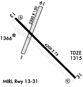
Runways
Runway Summary
| Runways: | 01/19 13/31 |
| Longest Runway: | 13/31 is 4210 ft (1283 m) long |
| Runways with an Instrument Approach: |
TTO Airport Runway Details
| Runway 01/19 | 2034 ft x 120 ft (620 m x 37 m) | |
| Runway Length Source: | 3RD PARTY SURVEY as of 09/07/2008 | |
| Surface: | Turf - Fair condition - No special surface treatment | |
Runway 01 |
Runway 19 |
|
Elevation: |
1312.4 | 1312.6 |
Latitude: |
45-48-50.3506N | 45-49-08.7843N |
Longitude: |
097-44-46.1790W | 097-44-34.7992W |
|
Runway True Alignment: |
023 | 203 |
Glide Path Angle: |
0.0 degrees | 0.0 degrees |
Traffic Pattern: |
Left | Left |
Runway Markings Type: |
Nonstandard (other than numbers only) | Nonstandard (other than numbers only) |
Object at End: |
FENCE | ROAD |
Object Height: |
6 | 18 |
Distance from End: |
125 | 390 |
Object Centerline Offset: |
0 ft. left and right of centerline | 0 ft. left and right of centerline |
REIL: |
No | No |
Touchdown Lights: |
No | No |
Centerline Lights: |
No | No |
| Runway 13/31 | 4210 ft x 75 ft (1283 m x 23 m) | |
| Runway Length Source: | 3RD PARTY SURVEY as of 09/07/2008 | |
| Surface: | Turf - Fair condition - No special surface treatment | |
| Runway Edge Lights: | Medium Intensity | |
Runway Weight Bearing Capacity (in thousands of pounds) |
||
| Single Wheel Landing Gear: | 12.5 | |
Runway 13 |
Runway 31 |
|
Elevation: |
1314.6 | 1318.4 |
Latitude: |
45-49-06.1719N | 45-48-36.8475N |
Longitude: |
097-44-52.0282W | 097-44-09.9213W |
|
Runway True Alignment: |
135 | 315 |
Glide Path Angle: |
3.0 degrees | 3.2 degrees |
Traffic Pattern: |
Left | Left |
Runway Markings Type: |
Nonprecision Instrument | Nonprecision Instrument |
Runway Markings Condition: |
Good | Good |
Object at End: |
ROAD | TREES |
Object Height: |
15 | 88 |
Distance from End: |
800 | 1990 |
Object Centerline Offset: |
0 ft. left and right of centerline | 0 ft. left and right of centerline |
Visual Glide Slope Indicators: |
2-Light PAPI On Left Side Of Runway | 2-Light PAPI On Left Side Of Runway |
REIL: |
Yes | Yes |
Touchdown Lights: |
No | No |
Centerline Lights: |
No | No |
Threshold Crossing Height: |
38 | 33 |
Services
Airframe Repair: |
None |
Powerplant Repair: |
None |
Bottled Oxygen: |
None |
Bulk Oxygen: |
None |
Fuel Available: |
100LL, Jet A |
Landing Fees: |
No |
Parking: |
Hangars and tiedowns available |
Maps & Diagrams
TTO Sectional
Flight Planning
at skyvector.com
at skyvector.com