Location
Latitude: |
60-34-10.3000N (60.569528) |
Longitude: |
165-14-46.6000W (-165.246278) |
Elevation: |
62.3 feet MSL (19 m MSL) |
Magnetic Variation: |
8.2 E (as of April 2024 from WMM2020 model) |
Time Zone: |
UTC -9.0 (Standard Time) UTC -8.0 (Daylight Savings Time) |
From City: |
01 N.M. SW of Tununak, Alaska |
Found On: |
Bethel Chart |
FAA Region: |
AAL |
Contacts
Manager: |
Publicly owned: |
| JOSEPH LARAUX PO BOX 505 BETHEL, AK 99559 907-543-2495 |
ALASKA DOT&PF CENTRAL REGION PO BOX 196900 ANCHORAGE, AK 99519-6900 (907) 543-3498 |
Operations
Airport Status: |
Operational |
Facility Use: |
Public |
Type: |
Airport |
Control tower: |
No |
Attendance (Months/Days/Hours): |
Months/Days/Hours Unattended |
Boundary ARTCC: |
ZAN (Anchorage) |
Responsible ARTCC: |
ZAN (Anchorage) |
Lighting Schedule: |
SS-SR |
Segmented Circle Indicator: |
Yes |
Traffic Pattern Altitude (MSL): |
1062 feet (324 m) |
NOTAMs Facility: |
ENA |
NOTAM-D Service: |
Yes |
International Airport of Entry: |
No |
Customs Landing Rights: |
No |
Military Landing Rights: |
Yes |
Civil/Military Joint Use: |
No |
Based Aircraft
Annual Operations (as of 12/31/2022)
| Total Operations: | 300 | |
| Air Taxi: | 300 | 100.0% |
Communications
| CTAF: | 122.900 |
| AWOS-3PT: | 118.25 (907-269-2788) |
Fixed Based Operators (FBOs) & Fuel
(Click on a business for detail)
Please help us keep this information up to date. This is a FREE SERVICE just like everything else on Airport Guide! If you see that a business needs to be added, modified, or deleted please fill out our Update Form.
To add, modify, or delete a business click here.
Please help us keep this information up to date. This is a FREE SERVICE just like everything else on Airport Guide! If you see that a business needs to be added, modified, or deleted please fill out our Update Form.
Area Code: 907 |
| Business Name | Frequency | Phone | Fuel Grade |
|---|
Flight Service Stations
| Primary | Alternate | |
| FSS on Field: | N | |
| FSS Name (ID): | Kenai(ENA) | |
| Frequency: | ||
| Toll Free Phone: | 1-866-864-1737 |
Instrument Procedures / Charts
Terminal Procedures are only available for airports in several countries with more being added all the time. If you are looking for a specific country's charts, please send an email to support(at)airportguide.com stating the country name. This will be used to prioritize the implementation.
Navigation Aids (Navaids) near TNK
| Dist (NM) | ID | Morse Code | Name | Type | Freq | True Hdg | Mag Hdg |
|---|---|---|---|---|---|---|---|
| 30.7 | AIX | . _ . . _ . . _ | Nanwak | NDB-DME | 323 | 249 | 241 |
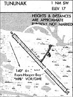
| 62.3 | HPB | . . . . . _ _ . _ . . . | Hooper Bay | VOR-DME | 115.20 | 335 | 327 |
| 76.0 | CZF | _ . _ . _ _ . . . . _ . | Cape Romanzof | DME | 116.75 | 342 | 334 |
| 76.2 | CZF | _ . _ . _ _ . . . . _ . | Cape Romanzof | NDB | 275 | 344 | 336 |
| 100.0 | OSE | _ _ _ . . . . | Oscarville | NDB | 251 | 80 | 71 |
Nearby Airports with Fuel
| Dist (NM) | Name (Airport IDs) | True Hdg | Mag Hdg | Fuel Grade |
|---|
Notices to Airmen (NOTAMS)
Remarks
| A110-1 | RWY CONDITION NOT MONITORED; RECOMMEND VISUAL INSPECTION PRIOR TO USING. |
| A110-2 | BIRDS AND WILDLIFE ON & IN VICINITY OF ARPT. |
| A110-3 | HEAVES AND DIPS FULL LENGTH OF RWY. |
Runways
Runway Summary
| Runways: | 16/34 |
| Longest Runway: | 16/34 is 3300 ft (1006 m) long |
| Runways with an Instrument Approach: |
TNK Airport Runway Details
| Runway 16/34 | 3300 ft x 75 ft (1006 m x 23 m) | |
| Runway Length Source: | 3RD PARTY SURVEY as of 07/05/2016 | |
| Surface: | Gravel - Good condition - No special surface treatment | |
| Runway Edge Lights: | Medium Intensity | |
Runway 16 |
Runway 34 |
|
Elevation: |
52.4 | 62.3 |
Latitude: |
60-34-26.1868N | 60-33-54.4169N |
Longitude: |
165-14-53.5657W | 165-14-39.6754W |
|
Runway True Alignment: |
168 | 348 |
Glide Path Angle: |
0.0 degrees | 0.0 degrees |
Traffic Pattern: |
Left | Left |
Object at End: |
HILL | |
Object Height: |
50 | |
Distance from End: |
1470 | |
Object Centerline Offset: |
420 ft. right of centerline |
Services
Airframe Repair: |
None |
Powerplant Repair: |
None |
Bottled Oxygen: |
None |
Bulk Oxygen: |
None |
Landing Fees: |
No |
Maps & Diagrams
TNK Sectional
Flight Planning
at skyvector.com
at skyvector.com