Location
Latitude: |
32-28-57.9000N (32.48275) |
Longitude: |
081-44-13.0000W (-81.736944) |
Elevation: |
186.7 feet MSL (57 m MSL) |
Magnetic Variation: |
7.1 W (as of April 2024 from WMM2020 model) |
Time Zone: |
UTC -5.0 (Standard Time) UTC -4.0 (Daylight Savings Time) |
From City: |
03 N.M. NE of Statesboro, Georgia |
Found On: |
Atlanta Chart |
FAA Region: |
ASO |
Contacts
Manager: |
Publicly owned: |
| DAVID CAMPBELL 601 AIRPORT BLVD STATESBORO, GA 30461 912-764-9083 |
STATESBORO CITY & BULLOCH COUNTY 115 NORTH MAIN STREET STATESBORO, GA 30458 912-764-5468 |
Operations
Airport Status: |
Operational |
Facility Use: |
Public |
Type: |
Airport |
Activation Date: |
04/1940 |
Control tower: |
No |
Attendance (Months/Days/Hours): |
Months/Days/Hours ALL/MON-FRI/0800-1900 |
Boundary ARTCC: |
ZJX (Jacksonville) |
Responsible ARTCC: |
ZJX (Jacksonville) |
Lighting Schedule: |
SEE RMK |
Segmented Circle Indicator: |
Yes |
Traffic Pattern Altitude (MSL): |
1187 feet (362 m) |
NOTAMs Facility: |
TBR |
NOTAM-D Service: |
Yes |
International Airport of Entry: |
No |
Customs Landing Rights: |
No |
Military Landing Rights: |
Yes |
Civil/Military Joint Use: |
No |
Based Aircraft
| Single Engine: | 54 |
| Multi Engine: | 1 |
Annual Operations (as of 12/31/2022)
| Total Operations: | 29680 | |
| GA Local: | 13000 | 43.8% |
| GA Itinerant: | 16180 | 54.5% |
| Military Aircraft: | 500 | 1.7% |
Communications
| CTAF: | 122.725 |
| Unicom: | 122.725 |
| Approach: | SAVANNAH 118.4 118.4 JAX ARTCC |
| Departure: | SAVANNAH 118.4 118.4 JAX ARTCC |
| AWOS-3: | 119.025 (912-764-9321) |
- APCH/DEP SVC PRVDD BY JAX ARTCC ON FREQS 132.925/363.2 (MILLEN RCAG) WHEN SAVANNAH APCH CTL CLSD.
Fixed Based Operators (FBOs) & Fuel
(Click on a business for detail)
Please help us keep this information up to date. This is a FREE SERVICE just like everything else on Airport Guide! If you see that a business needs to be added, modified, or deleted please fill out our Update Form.
To add, modify, or delete a business click here.
Please help us keep this information up to date. This is a FREE SERVICE just like everything else on Airport Guide! If you see that a business needs to be added, modified, or deleted please fill out our Update Form.
Area Code: 912 |
| Business Name | Frequency | Phone | Fuel Grade |
|---|
Flight Service Stations
| Primary | Alternate | |
| FSS on Field: | N | |
| FSS Name (ID): | Macon(MCN) | |
| Frequency: | ||
| Toll Free Phone: | 1-800-WX-BRIEF |
Instrument Procedures / Charts
FAA Terminal Procedures valid from 0901Z 03/21/24 to 0901Z 04/18/24.
There are various types of charts available for an airport. They are listed in the Page Type column. Here is a legend for those types:
APD - Airport Diagram
DP - Departure Procedure Charts
HOT - Hot Spots
IAP - Instrument Approach Procedure Charts
MIN - Minimums
STAR - Standard Terminal Arrival Charts
| Page Type | Page Name | Volume | Action Since Last Cycle |
|---|---|---|---|
| IAP | ILS OR LOC RWY 32 | SE-4 | |
| IAP | RNAV (GPS) RWY 14 | SE-4 | |
| IAP | RNAV (GPS) RWY 32 | SE-4 | |
| MIN | ALTERNATE MINIMUMS | SE-4 | |
| MIN | TAKEOFF MINIMUMS | SE-4 |
Terminal Procedures are only available for airports in several countries with more being added all the time. If you are looking for a specific country's charts, please send an email to support(at)airportguide.com stating the country name. This will be used to prioritize the implementation.
Navigation Aids (Navaids) near TBR
| Dist (NM) | ID | Morse Code | Name | Type | Freq | True Hdg | Mag Hdg |
|---|---|---|---|---|---|---|---|
| 5.5 | BZ | _ . . . _ _ . . | Bullo | NDB | 407 | 137 | 144 |
| 12.3 | JYL | . _ _ _ _ . _ _ . _ . . | Sylvania | NDB | 245 | 35 | 42 |
| 18.7 | CWV | _ . _ . . _ _ . . . _ | Claxton | NDB | 395 | 201 | 208 |
| 27.3 | LNH | . _ . . _ . . . . . | Millen | NDB | 205 | 334 | 341 |
| 29.5 | SA | . . . . _ | Mavis | NDB | 368 | 135 | 142 |
| 32.4 | UQN | . . _ _ _ . _ _ . | Onyun | NDB | 372 | 241 | 248 |
| 33.1 | RVJ | . _ . . . . _ . _ _ _ | Prison | NDB | 424 | 219 | 226 |
| 33.9 | SAV | . . . . _ . . . _ | Savannah | VORTAC | 115.95 | 126 | 133 |
| 34.5 | SAV | . . . . _ . . . _ | Savannah Travis Fld | VOT | 111.00 | 128 | 135 |
| 37.8 | EEX | . . _ . . _ | Emanuel County | NDB | 309 | 287 | 294 |
| 38.9 | ALD | . _ . _ . . _ . . | Allendale | VOR | 116.70 | 35 | 42 |
| 40.8 | MOQ | _ _ _ _ _ _ _ . _ | Mc Intosh | NDB | 263 | 163 | 170 |
| 41.4 | SVN | . . . . . . _ _ . | Hunter | VOR-DME | 111.60 | 132 | 139 |
| 47.7 | SV | . . . . . . _ | Wassa | NDB | 335 | 126 | 133 |
| 49.4 | AG | . _ _ _ . | Bushe | NDB | 233 | 347 | 354 |
| 51.6 | NBC | _ . _ . . . _ . _ . | Beaufort | TACAN | 110.50 | 89 | 96 |
| 55.5 | DBN | _ . . _ . . . _ . | Dublin | VORTAC | 113.10 | 275 | 282 |
| 56.3 | JES | . _ _ _ . . . . | Slover | NDB | 340 | 187 | 194 |
| 56.9 | BHC | _ . . . . . . . _ . _ . | Baxley | NDB | 376 | 215 | 222 |
| 58.7 | AZE | . _ _ _ . . . | Hazlehurst | NDB | 414 | 232 | 239 |
Nearby Airports with Fuel
Notices to Airmen (NOTAMS)
Remarks
| A110*G | THIS AIRPORT HAS BEEN SURVEYED BY THE NATIONAL GEODETIC SURVEY. |
| A110-1 | BIRDS & DEER ON & INVOF ARPT. |
| A110-2 | FOR CD CTC SAVANNAH APCH AT 912-964-3205, WHEN APCH CLSD CTC JACKSONVILLE ARTCC AT 904-845-1592. |
| A39-06/24 | PCR VALUE: 285/F/C/X/T |
| A39-14/32 | PCR VALUE: 522/F/B/X/T |
| A57-32 | APPROACH SLOPE TO DSPLCD THR IS 34:1; TREES 714 FT FROM DSPLCD THR 500 FT LEFT. |
| A70-FUEL-10 | 0LL 24 HR SELF-SERVE FUEL AVBL. |
| A81-APT | HIRL RWY 14/32 PRESET ON MED INTST DUSK-2300; TO INCR INTST & ACTVT HIRL AFTER 2300 - CTAF. ACTVT MALSR RWY 32; PAPI RWY 14 & 32 - CTAF. |
| E111 | EXISTED PRIOR TO 1959. |
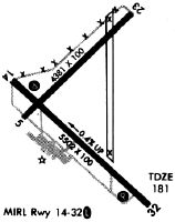
Runways
Runway Summary
| Runways: | 06/24 14/32 |
| Longest Runway: | 14/32 is 6000 ft (1829 m) long |
| Runways with an Instrument Approach: | 32 |
TBR Airport Runway Details
| Runway 06/24 | 4382 ft x 100 ft (1336 m x 30 m) | |
| Runway Length Source: | 3RD PARTY SURVEY as of 11/17/2009 | |
| Surface: | Asphalt - Good condition - No special surface treatment | |
Runway Weight Bearing Capacity (in thousands of pounds) |
||
| Single Wheel Landing Gear: | 73.0 | |
| Dual Wheel Landing Gear: | 105.0 | |
| Dual Tandem Wheel Landing Gear: | 172.0 | |
Runway 06 |
Runway 24 |
|
Elevation: |
177.8 | 186.7 |
Latitude: |
32-28-58.5000N | 32-29-26.6185N |
Longitude: |
081-44-34.1508W | 081-43-55.2043W |
|
Runway True Alignment: |
050 | 230 |
Glide Path Angle: |
0.0 degrees | 0.0 degrees |
Traffic Pattern: |
Left | Left |
Runway Markings Type: |
Basic | Basic |
Runway Markings Condition: |
Good | Good |
Object at End: |
TREES | TREES |
Object Height: |
78 | 31 |
Distance from End: |
1729 | 455 |
Object Centerline Offset: |
385 ft. left of centerline | 256 ft. left of centerline |
| Runway 14/32 | 6000 ft x 100 ft (1829 m x 30 m) | |
| Runway Length Source: | 3RD PARTY SURVEY as of 11/17/2009 | |
| Surface: | Asphalt - Good condition - No special surface treatment | |
| Runway Edge Lights: | High Intensity | |
Runway Weight Bearing Capacity (in thousands of pounds) |
||
| Single Wheel Landing Gear: | 120.0 | |
| Dual Wheel Landing Gear: | 211.0 | |
| Dual Tandem Wheel Landing Gear: | 358.0 | |
| Dual Dual Tandem Wheel Landing Gear: | 851.0 | |
Runway 14 |
Runway 32 |
|
Elevation: |
180.8 | 157.2 |
Latitude: |
32-29-08.1335N | 32-28-26.1105N |
Longitude: |
081-44-36.4912W | 081-43-47.0095W |
|
Runway True Alignment: |
135 | 315 |
ILS Type: |
ILS | |
Glide Path Angle: |
4.0 degrees | 3.0 degrees |
Traffic Pattern: |
Left | Left |
Runway Markings Type: |
Precision Instrument | Precision Instrument |
Runway Markings Condition: |
Good | Good |
Object at End: |
TREES | ROAD |
Object Height: |
36 | 15 |
Distance from End: |
803 | 380 |
Object Centerline Offset: |
385 ft. left of centerline | 256 ft. left of centerline |
Visual Glide Slope Indicators: |
2-Light PAPI On Left Side Of Runway | 2-Light PAPI On Left Side Of Runway |
Approach Light System: |
1,400 Foot Medium Intensity Approach Lighting System With Runway Alignment Indicator Lights | |
Threshold Crossing Height: |
42 | 47 |
Threshold Elevation: |
158.5 | |
Displaced Threshold: |
299 | |
Threshold Latitude: |
32-28-28.2076N | |
Threshold Longitude: |
081-43-49.4784W | |
Declared Distances |
||
Take Off Run Avbl. (TORA): |
6000 | 6000 |
Take Off Distance Avbl. (TODA): |
6000 | 6000 |
Actual Stop Dist. Avbl. (ASDA): |
6000 | 6000 |
Landing Dist. Avbl. (LDA): |
6000 | 5701 |
Services
Airframe Repair: |
Minor |
Powerplant Repair: |
Minor |
Bottled Oxygen: |
High Pressure / Low Pressure |
Bulk Oxygen: |
High Pressure / Low Pressure |
Fuel Available: |
100LL, Jet A+ |
Landing Fees: |
No |
Parking: |
Hangars and tiedowns available |
Maps & Diagrams
TBR Sectional
Flight Planning
at skyvector.com
at skyvector.com