Location
Latitude: |
33-59-42.0920N (33.995026) |
Longitude: |
080-21-40.7840W (-80.361329) |
Elevation: |
182.1 feet MSL (56 m MSL) |
Magnetic Variation: |
8.1 W (as of April 2024 from WMM2020 model) |
Time Zone: |
UTC -5.0 (Standard Time) UTC -4.0 (Daylight Savings Time) |
From City: |
04 N.M. N of Sumter, South Carolina |
Found On: |
Charlotte Chart |
FAA Region: |
ASO |
Contacts
Manager: |
Publicly owned: |
| JEFF KNAUER 2945 AIRPORT ROAD SUMTER, SC 29153 803-469-4639 |
COUNTY OF SUMTER 13 EAST CANAL STREET SUMTER, SC 29150 (803) 469-4639 |
Operations
Airport Status: |
Operational |
Facility Use: |
Public |
Type: |
Airport |
Activation Date: |
02/1957 |
Control tower: |
No |
Attendance (Months/Days/Hours): |
Months/Days/Hours ALL/ALL/0800-1800 |
Boundary ARTCC: |
ZJX (Jacksonville) |
Responsible ARTCC: |
ZJX (Jacksonville) |
Lighting Schedule: |
SEE RMK |
Segmented Circle Indicator: |
Yes |
Traffic Pattern Altitude (MSL): |
1182 feet (360 m) |
NOTAMs Facility: |
AND |
NOTAM-D Service: |
Yes |
International Airport of Entry: |
No |
Customs Landing Rights: |
No |
Military Landing Rights: |
Yes |
Civil/Military Joint Use: |
No |
Based Aircraft
| Single Engine: | 21 |
| Multi Engine: | 5 |
| Jet Engine: | 4 |
| GA Helicopters: | 1 |
Annual Operations (as of 06/17/2021)
| Total Operations: | 12100 | |
| Air Taxi: | 353 | 2.9% |
| GA Local: | 7260 | 60.0% |
| GA Itinerant: | 4387 | 36.3% |
| Military Aircraft: | 100 | 0.8% |
Communications
| CTAF: | 122.700 |
| Unicom: | 122.700 |
| Approach: | SHAW 125.4 JAX ARTCC |
| Departure: | SHAW 125.4 JAX ARTCC |
| AWOS-3: | 118.075 (803-469-6750) |
- APCH/DEP SVC PRVDD BY JACKSONVILLE ARTCC ON FREQS 124.7/269.55 (COLUMBIA RCAG) WHEN SHAW APCH CTL CLSD.
Fixed Based Operators (FBOs) & Fuel
(Click on a business for detail)
Please help us keep this information up to date. This is a FREE SERVICE just like everything else on Airport Guide! If you see that a business needs to be added, modified, or deleted please fill out our Update Form.
To add, modify, or delete a business click here.
Please help us keep this information up to date. This is a FREE SERVICE just like everything else on Airport Guide! If you see that a business needs to be added, modified, or deleted please fill out our Update Form.
Area Code: 803 |
| Business Name | Frequency | Phone | Fuel Grade |
|---|
Flight Service Stations
| Primary | Alternate | |
| FSS on Field: | N | |
| FSS Name (ID): | Anderson(AND) | |
| Frequency: | ||
| Toll Free Phone: | 1-800-WX-BRIEF |
Instrument Procedures / Charts
FAA Terminal Procedures valid from 0901Z 03/21/24 to 0901Z 04/18/24.
There are various types of charts available for an airport. They are listed in the Page Type column. Here is a legend for those types:
APD - Airport Diagram
DP - Departure Procedure Charts
HOT - Hot Spots
IAP - Instrument Approach Procedure Charts
MIN - Minimums
STAR - Standard Terminal Arrival Charts
| Page Type | Page Name | Volume | Action Since Last Cycle |
|---|---|---|---|
| IAP | ILS OR LOC RWY 23 | SE-2 | |
| IAP | RNAV (GPS) RWY 05 | SE-2 | |
| IAP | RNAV (GPS) RWY 23 | SE-2 | |
| MIN | ALTERNATE MINIMUMS | SE-2 | |
| MIN | TAKEOFF MINIMUMS | SE-2 |
Terminal Procedures are only available for airports in several countries with more being added all the time. If you are looking for a specific country's charts, please send an email to support(at)airportguide.com stating the country name. This will be used to prioritize the implementation.
Navigation Aids (Navaids) near SUM
| Dist (NM) | ID | Morse Code | Name | Type | Freq | True Hdg | Mag Hdg |
|---|---|---|---|---|---|---|---|
| 0.3 | SMS | . . . _ _ . . . | Sumter | NDB | 252 | 165 | 173 |
| 5.3 | SSC | . . . . . . _ . _ . | Shaw | TACAN | 110.10 | 258 | 266 |
| 22.4 | MMT | _ _ _ _ _ | Mc Entire | VORTAC | 113.20 | 259 | 267 |
| 25.6 | MNI | _ _ _ . . . | Manning | NDB | 381 | 162 | 170 |
| 27.4 | HVS | . . . . . . . _ . . . | Hartsville | NDB | 341 | 25 | 33 |
| 27.5 | FL | . . _ . . _ . . | Alcot | NDB | 335 | 66 | 74 |
| 30.2 | CKI | _ . _ . _ . _ . . | Kingstree | NDB | 404 | 123 | 131 |
| 30.8 | CFY | _ . _ . . . _ . _ . _ _ | Evans | NDB | 420 | 105 | 113 |
| 31.5 | VAN | . . . _ . _ _ . | Vance | VORTAC | 110.40 | 187 | 195 |
| 35.5 | CAE | _ . _ . . _ . | Columbia | VORTAC | 114.70 | 256 | 264 |
| 35.7 | UDG | . . _ _ . . _ _ . | Darlington | NDB | 245 | 41 | 49 |
| 37.8 | FLO | . . _ . . _ . . _ _ _ | Florence | VORTAC | 115.20 | 67 | 75 |
| 39.6 | CTF | _ . _ . _ . . _ . | Chesterfield | VOR-DME | 114.55 | 6 | 14 |
| 40.7 | EDS | . _ . . . . . | Edisto | VOR-DME | 111.40 | 217 | 225 |
| 41.9 | FDW | . . _ . _ . . . _ _ | Winnsboro | NDB | 414 | 297 | 305 |
| 44.0 | CA | _ . _ . . _ | Murry | NDB | 362 | 268 | 276 |
| 44.6 | HEK | . . . . . _ . _ | Stuckey | NDB | 236 | 110 | 118 |
| 45.0 | PYG | . _ _ . _ . _ _ _ _ . | Pageland | NDB | 270 | 1 | 9 |
| 48.7 | BES | _ . . . . . . . | Bennettsville | NDB | 230 | 39 | 47 |
| 50.1 | LKR | . _ . . _ . _ . _ . | Lancaster | NDB | 400 | 330 | 338 |
Nearby Airports with Fuel
Notices to Airmen (NOTAMS)
Remarks
| A110-2 | WILDLIFE ON & INVOF ARPT WITH INCR ACTVTY DUSK & DAWN. |
| A110-3 | FOR CD CTC SHAW APCH AT 803-895-4884, WHEN APCH CLSD CTC JACKSONVILLE ARTCC AT 904-845-1592. |
| A70-FUEL-10 | 0LL FOR FUEL AFT 2000 CALL 803-983-6577. |
| A76 | AVIONICS SVCS SKED TO BE AVAILABLE MID-JULY 2021. |
| A81-APT | AFTER 2000, ACTVT MIRL RY 05/23, REILS RY 05/23 - CTAF. PAPI RYS 05 & 23 OPERATE CONTINUOUSLY. |
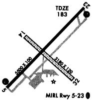
Runways
Runway Summary
| Runways: | 05/23 14/32 |
| Longest Runway: | 05/23 is 5501 ft (1677 m) long |
| Runways with an Instrument Approach: | 23 |
SUM Airport Runway Details
| Runway 05/23 | 5501 ft x 100 ft (1677 m x 30 m) | |
| Runway Length Source: | 3RD PARTY SURVEY as of 01/08/2006 | |
| Surface: | Asphalt - Good condition - No special surface treatment | |
| Runway Pavement Class: | 12 /F/D/Y/T | |
| Runway Edge Lights: | Medium Intensity | |
Runway Weight Bearing Capacity (in thousands of pounds) |
||
| Single Wheel Landing Gear: | 31.5 | |
| Dual Wheel Landing Gear: | 42.5 | |
Runway 05 |
Runway 23 |
|
Elevation: |
178.7 | 181.8 |
Latitude: |
33-59-24.6819N | 34-00-04.3688N |
Longitude: |
080-22-03.7647W | 080-21-19.0649W |
|
Runway True Alignment: |
043 | 223 |
ILS Type: |
ILS/DME | |
Glide Path Angle: |
3.0 degrees | 3.0 degrees |
Traffic Pattern: |
Right | Left |
Runway Markings Type: |
Nonprecision Instrument | Precision Instrument |
Runway Markings Condition: |
Good | Good |
Object at End: |
TREES | TREES |
Object Height: |
77 | 87 |
Distance from End: |
2373 | 2748 |
Object Centerline Offset: |
565 ft. left of centerline | 659 ft. left of centerline |
Visual Glide Slope Indicators: |
4-Light PAPI On Left Side Of Runway | 4-Light PAPI On Left Side Of Runway |
Approach Light System: |
Omnidirectional Approach Lighting System | |
REIL: |
Yes | Yes |
Touchdown Lights: |
No | No |
Centerline Lights: |
No | No |
Threshold Crossing Height: |
46 | 45 |
| Runway 14/32 | 3081 ft x 120 ft (939 m x 37 m) | |
| Runway Length Source: | 3RD PARTY SURVEY as of 01/08/2006 | |
| Surface: | Asphalt - Good condition - No special surface treatment | |
Runway 14 |
Runway 32 |
|
Elevation: |
176.9 | 179.3 |
Latitude: |
33-59-48.3359N | 33-59-27.1661N |
Longitude: |
080-21-52.8248W | 080-21-26.4926W |
|
Runway True Alignment: |
134 | 314 |
Glide Path Angle: |
0.0 degrees | 0.0 degrees |
Traffic Pattern: |
Left | Right |
Runway Markings Type: |
None | None |
Object at End: |
TREES | TREE |
Object Height: |
84 | 94 |
Distance from End: |
941 | 1369 |
Object Centerline Offset: |
565 ft. left of centerline | 659 ft. left of centerline |
REIL: |
No | No |
Touchdown Lights: |
No | No |
Centerline Lights: |
No | No |
Services
Airframe Repair: |
Major |
Powerplant Repair: |
Major |
Bottled Oxygen: |
None |
Bulk Oxygen: |
None |
Fuel Available: |
100LL, Mogas |
Landing Fees: |
No |
Parking: |
Tiedowns available |
Maps & Diagrams
SUM Sectional
Flight Planning
at skyvector.com
at skyvector.com