Location
Latitude: |
38-20-24.6820N (38.340189) |
Longitude: |
075-30-34.1210W (-75.509478) |
Elevation: |
52.5 feet MSL (16 m MSL) |
Magnetic Variation: |
11.5 W (as of April 2024 from WMM2020 model) |
Time Zone: |
UTC -5.0 (Standard Time) UTC -4.0 (Daylight Savings Time) |
From City: |
04 N.M. SE of Salisbury, Maryland |
Found On: |
Washington Chart |
FAA Region: |
AEA |
Contacts
Manager: |
Publicly owned: |
| ANTHONY RUDY 5485 AIRPORT TERMINAL RD, UNIT A SALISBURY, MD 21804 410-548-4827 |
WICOMICO COUNTY PO BOX 870 SALISBURY, MD 21803 410-548-4801 |
Operations
Airport Status: |
Operational |
Facility Use: |
Public |
Type: |
Airport |
Activation Date: |
02/1944 |
Control tower: |
Yes |
Attendance (Months/Days/Hours): |
Months/Days/Hours ALL/ALL/0530-2400 |
Boundary ARTCC: |
ZDC (Washington) |
Responsible ARTCC: |
ZDC (Washington) |
Lighting Schedule: |
SEE RMK |
Segmented Circle Indicator: |
No |
Traffic Pattern Altitude (MSL): |
1052 feet (321 m) |
NOTAMs Facility: |
SBY |
NOTAM-D Service: |
Yes |
International Airport of Entry: |
No |
Customs Landing Rights: |
No |
Military Landing Rights: |
Yes |
Civil/Military Joint Use: |
No |
Aircraft Rescue and Firefighting: |
Class I ARFF Index: B Air Carrier Service: Scheduled Certification Date: 05/1975 |
Based Aircraft
| Single Engine: | 55 |
| Multi Engine: | 4 |
| Jet Engine: | 54 |
| GA Helicopters: | 3 |
| Ultralights: | 1 |
Annual Operations (as of 12/31/2022)
| Total Operations: | 58791 | |
| Air Taxi: | 7218 | 12.3% |
| GA Local: | 13266 | 22.6% |
| GA Itinerant: | 16625 | 28.3% |
| Military Aircraft: | 21682 | 36.9% |
Communications
| CTAF: | 119.425 |
| Unicom: | 122.950 |
| Tower: | SALISBURY 119.425 Hrs: 0600-2230 |
| Clearance Del.: | 123.775 ;0600-2230 |
| Ground: | 123.775 |
| Approach: | PATUXENT POTOMAC 127.2 ;WHEN NHK APCH CLSD 127.2 ;WHEN NHK APCH CLSD 127.2 ;WHEN NHK APCH CLSD 127.2 ;WHEN NHK APCH CLSD |
| Departure: | PATUXENT POTOMAC 127.2 ;WHEN NHK APCH CLSD 127.2 ;WHEN NHK APCH CLSD 127.2 ;WHEN NHK APCH CLSD 127.2 ;WHEN NHK APCH CLSD |
| ASOS: | 118.325 (410-341-0868) |
- APCH/DEP SVC PRVDD BY POTOMAC TRACON APP/DEP CON 127.2/281.475 WHEN PATUXENT APCH CTL CLSD
Fixed Based Operators (FBOs) & Fuel
(Click on a business for detail)
Please help us keep this information up to date. This is a FREE SERVICE just like everything else on Airport Guide! If you see that a business needs to be added, modified, or deleted please fill out our Update Form.
To add, modify, or delete a business click here.
Please help us keep this information up to date. This is a FREE SERVICE just like everything else on Airport Guide! If you see that a business needs to be added, modified, or deleted please fill out our Update Form.
Area Code: 410 |
| Business Name | Frequency | Phone | Fuel Grade |
|---|---|---|---|
| Bay Land Aviation, Inc.
Update FBO info |
Unicom 122.95 | 749-0323 | 100LL, Jet A |
| Salisbury-Ocean City-Wicomico Regional
Update FBO info |
Unicom 122.95 | 548-4827 |
Flight Service Stations
| Primary | Alternate | |
| FSS on Field: | N | |
| FSS Name (ID): | Leesburg(DCA) | |
| Frequency: | ||
| Toll Free Phone: | 1-800-WX-BRIEF |
Instrument Procedures / Charts
FAA Terminal Procedures valid from 0901Z 03/21/24 to 0901Z 04/18/24.
There are various types of charts available for an airport. They are listed in the Page Type column. Here is a legend for those types:
APD - Airport Diagram
DP - Departure Procedure Charts
HOT - Hot Spots
IAP - Instrument Approach Procedure Charts
MIN - Minimums
STAR - Standard Terminal Arrival Charts
| Page Type | Page Name | Volume | Action Since Last Cycle |
|---|---|---|---|
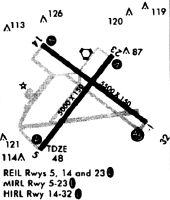
| APD | AIRPORT DIAGRAM | NE-3 | |
| IAP | ILS OR LOC RWY 32 | NE-3 | |
| IAP | RNAV (GPS) RWY 05 | NE-3 | |
| IAP | RNAV (GPS) RWY 14 | NE-3 | |
| IAP | RNAV (GPS) RWY 23 | NE-3 | |
| IAP | RNAV (GPS) RWY 32 | NE-3 | |
| IAP | VOR RWY 05 | NE-3 | |
| MIN | ALTERNATE MINIMUMS | NE-3 | |
| MIN | TAKEOFF MINIMUMS | NE-3 |
Terminal Procedures are only available for airports in several countries with more being added all the time. If you are looking for a specific country's charts, please send an email to support(at)airportguide.com stating the country name. This will be used to prioritize the implementation.
Navigation Aids (Navaids) near SBY
| Dist (NM) | ID | Morse Code | Name | Type | Freq | True Hdg | Mag Hdg |
|---|---|---|---|---|---|---|---|
| 0.3 | SBY | . . . _ . . . _ . _ _ | Salisbury | VORTAC | 111.20 | 349 | 361 |
| 14.7 | OX | _ _ _ _ . . _ | Landy | NDB | 407 | 84 | 96 |
| 17.2 | SWL | . . . . _ _ . _ . . | Snow Hill | VORTAC | 112.40 | 172 | 183 |
| 27.2 | CGE | _ . _ . _ _ . . | Cambridge | NDB | 355 | 295 | 306 |
| 31.5 | ATR | . _ _ . _ . | Waterloo | VOR-DME | 112.60 | 26 | 38 |
| 42.0 | PXT | . _ _ . _ . . _ _ | Patuxent | VORTAC | 117.60 | 265 | 276 |
| 42.2 | NHK | _ . . . . . _ . _ | Patuxent | NDB | 400 | 265 | 276 |
| 42.6 | NHK | _ . . . . . _ . _ | Nas Patuxent River | TACAN | 110.25 | 265 | 276 |
| 47.6 | DOV | _ . . _ _ _ . . . _ | Dover | TACAN | 110.00 | 2 | 14 |
| 48.2 | BDB | _ . . . _ . . _ . . . | Accom | NDB | 336 | 196 | 207 |
| 53.5 | ENO | . _ . _ _ _ | Smyrna | VORTAC | 111.40 | 359 | 371 |
| 56.2 | SIE | . . . . . . | Sea Isle | VORTAC | 114.80 | 36 | 48 |
| 62.0 | OTT | _ _ _ _ _ | Nottingham | VORTAC | 113.70 | 291 | 302 |
| 63.9 | CCV | _ . _ . _ . _ . . . . _ | Cape Charles | VORTAC | 112.20 | 201 | 212 |
| 67.0 | RNB | . _ . _ . _ . . . | Rainbow | NDB | 363 | 15 | 27 |
| 69.5 | ADW | . _ _ . . . _ _ | Andrews | VORTAC | 113.10 | 294 | 305 |
| 70.0 | ADW | . _ _ . . . _ _ | Andrews Afb | VOT | 109.60 | 293 | 304 |
| 73.4 | BAL | _ . . . . _ . _ . . | Baltimore | VORTAC | 115.10 | 313 | 324 |
| 73.6 | BUH | _ . . . . . _ . . . . | Anne Arundel | NDB | 260 | 307 | 318 |
| 74.3 | PPM | . _ _ . . _ _ . _ _ | Phillips | VOR-DME | 108.40 | 335 | 346 |
Nearby Airports with Fuel
Notices to Airmen (NOTAMS)
Remarks
| A110-1 | MIL TRNG ACT, DEER & BIRDS ON & INVOF ARPT. |
| A110-10 | FOR CD CTC PATUXENT APCH AT 301-342-3740, WHEN PATUXENT APCH IS CLSD CTC POTOMAC APCH AT 866-640-4124. |
| A110-11 | RWY 32 NSDT REFLECTIVE LNDG ZONE MKR PANELS ADJ TO RWY. |
| A110-12 | TWY E CLSD TO ACFT WINGSPAN MORE THAN 79 FT. |
| A110-13 | TWY G SOUTH 950FT CLSD TO ACFT WINGSPAN MORE THAN 49 FT. |
| A110-3 | FBO HRS 0700-1900LCL. FOR SERVICES AFTER HRS CALL 410-749-0323. |
| A26 | 24 HR PPR RQR FOR UNSKED ACR OPS CTC AMGR. |
| A81-APT | WHEN ATCT CLSD ACTVT MALSR RWY 32; REIL RWY 05, 14 & 23; MIRL RWY 05/23; HIRL RWY 14/32; TWY LGTS - CTAF. PAPI RWY 5, 14, 23 & 32 OPR CONSLY. |
| E111 | PRIOR TO 1959. |
Runways
Runway Summary
| Runways: | 05/23 14/32 |
| Longest Runway: | 14/32 is 6400 ft (1951 m) long |
| Runways with an Instrument Approach: | 32 |
SBY Airport Runway Details
| Runway 05/23 | 5000 ft x 100 ft (1524 m x 30 m) | |
| Runway Length Source: | 3RD PARTY SURVEY as of 10/20/2016 | |
| Surface: | Asphalt - Excellent condition - Saw-cut or plastic grooved | |
| Runway Pavement Class: | 21 /F/C/X/T | |
| Runway Edge Lights: | Medium Intensity | |
Runway Weight Bearing Capacity (in thousands of pounds) |
||
| Single Wheel Landing Gear: | 56.0 | |
| Dual Wheel Landing Gear: | 76.0 | |
| Dual Tandem Wheel Landing Gear: | 142.0 | |
Runway 05 |
Runway 23 |
|
Elevation: |
44.1 | 49.4 |
Latitude: |
38-20-02.1623N | 38-20-41.8114N |
Longitude: |
075-31-00.8862W | 075-30-23.4129W |
|
Runway True Alignment: |
037 | 217 |
Glide Path Angle: |
3.0 degrees | 3.0 degrees |
Traffic Pattern: |
Left | Left |
Runway Markings Type: |
Nonprecision Instrument | Nonprecision Instrument |
Runway Markings Condition: |
Good | Good |
Object at End: |
TREE | TREE |
Object Height: |
95 | 95 |
Distance from End: |
2920 | 2800 |
Object Centerline Offset: |
190 ft. left of centerline | 0 ft. left and right of centerline |
Visual Glide Slope Indicators: |
4-Light PAPI On Left Side Of Runway | 4-Light PAPI On Left Side Of Runway |
REIL: |
Yes | Yes |
Threshold Crossing Height: |
45 | 45 |
Declared Distances |
||
Take Off Run Avbl. (TORA): |
5000 | 5000 |
Take Off Distance Avbl. (TODA): |
5000 | 5000 |
Actual Stop Dist. Avbl. (ASDA): |
5000 | 5000 |
Landing Dist. Avbl. (LDA): |
5000 | 5000 |
| Runway 14/32 | 6400 ft x 100 ft (1951 m x 30 m) | |
| Runway Length Source: | 3RD PARTY SURVEY as of 10/20/2016 | |
| Surface: | Asphalt - Excellent condition - Saw-cut or plastic grooved | |
| Runway Pavement Class: | 43 /F/C/W/T | |
| Runway Edge Lights: | High Intensity | |
Runway Weight Bearing Capacity (in thousands of pounds) |
||
| Single Wheel Landing Gear: | 76.0 | |
| Dual Wheel Landing Gear: | 126.0 | |
| Dual Tandem Wheel Landing Gear: | 423.0 | |
| Dual Dual Tandem Wheel Landing Gear: | 749.0 | |
Runway 14 |
Runway 32 |
|
Elevation: |
46.2 | 52.5 |
Latitude: |
38-20-45.6794N | 38-20-07.8918N |
Longitude: |
075-31-00.0616W | 075-29-55.6389W |
|
Runway True Alignment: |
127 | 307 |
ILS Type: |
ILS | |
Glide Path Angle: |
3.0 degrees | 3.0 degrees |
Traffic Pattern: |
Left | Left |
Runway Markings Type: |
Nonprecision Instrument | Precision Instrument |
Runway Markings Condition: |
Good | Good |
Object Centerline Offset: |
190 ft. left of centerline | 0 ft. left and right of centerline |
Visual Glide Slope Indicators: |
4-Light PAPI On Left Side Of Runway | 4-Light PAPI On Left Side Of Runway |
Approach Light System: |
1,400 Foot Medium Intensity Approach Lighting System With Runway Alignment Indicator Lights | |
REIL: |
Yes | |
Threshold Crossing Height: |
45 | 54 |
Declared Distances |
||
Take Off Run Avbl. (TORA): |
6400 | 6400 |
Take Off Distance Avbl. (TODA): |
6400 | 6400 |
Actual Stop Dist. Avbl. (ASDA): |
6400 | 6400 |
Landing Dist. Avbl. (LDA): |
6400 | 6400 |
Services
Airframe Repair: |
Major |
Powerplant Repair: |
Major |
Bottled Oxygen: |
None |
Bulk Oxygen: |
None |
Fuel Available: |
100LL |
Landing Fees: |
No |
Parking: |
Tiedowns available |
Maps & Diagrams
SBY Sectional
Flight Planning
at skyvector.com
at skyvector.com