Location
Latitude: |
33-57-06.8000N (33.951889) |
Longitude: |
117-26-42.4000W (-117.445111) |
Elevation: |
818.9 feet MSL (250 m MSL) |
Magnetic Variation: |
11.3 E (as of April 2024 from WMM2020 model) |
Time Zone: |
UTC -8.0 (Standard Time) UTC -7.0 (Daylight Savings Time) |
From City: |
04 N.M. SW of Riverside, California |
Found On: |
Los Angeles Chart |
FAA Region: |
AWP |
Contacts
Manager: |
Publicly owned: |
| DR. DANIEL PRATHER 6951 FLIGHT ROAD RIVERSIDE, CA 92504 951-351-6113 |
CITY OF RIVERSIDE 6951 FLIGHT ROAD RIVERSIDE, CA 92504 951-351-6113 |
Operations
Airport Status: |
Operational |
Facility Use: |
Public |
Type: |
Airport |
Activation Date: |
04/1940 |
Control tower: |
Yes |
Attendance (Months/Days/Hours): |
Months/Days/Hours ALL/S-S/0600-1600 |
Boundary ARTCC: |
ZLA (Los Angeles) |
Responsible ARTCC: |
ZLA (Los Angeles) |
Lighting Schedule: |
SEE RMK |
Segmented Circle Indicator: |
Yes |
Traffic Pattern Altitude (MSL): |
1819 feet (554 m) |
NOTAMs Facility: |
RAL |
NOTAM-D Service: |
Yes |
International Airport of Entry: |
No |
Customs Landing Rights: |
No |
Military Landing Rights: |
Yes |
Civil/Military Joint Use: |
No |
Based Aircraft
| Single Engine: | 191 |
| Multi Engine: | 18 |
| Jet Engine: | 5 |
| GA Helicopters: | 3 |
Annual Operations (as of 08/31/2022)
| Total Operations: | 116185 | |
| Air Taxi: | 2310 | 2.0% |
| GA Local: | 71168 | 61.3% |
| GA Itinerant: | 42497 | 36.6% |
| Military Aircraft: | 210 | 0.2% |
Communications
| CTAF: | 121.000 |
| Unicom: | 122.950 |
| Tower: | RIVERSIDE 121.0 257.8 Hrs: 0700-2000 |
| Ground: | 124.12 |
| Approach: | SOCAL |
| Departure: | SOCAL |
| ATIS: | 128.8 Hrs: 24 |
| ASOS: | 128.8 (951-352-4392) |
Fixed Based Operators (FBOs) & Fuel
(Click on a business for detail)
Please help us keep this information up to date. This is a FREE SERVICE just like everything else on Airport Guide! If you see that a business needs to be added, modified, or deleted please fill out our Update Form.
To add, modify, or delete a business click here.
Please help us keep this information up to date. This is a FREE SERVICE just like everything else on Airport Guide! If you see that a business needs to be added, modified, or deleted please fill out our Update Form.
Area Code: 909 |
| Business Name | Frequency | Phone | Fuel Grade |
|---|---|---|---|
| Golden West Avionics
Update FBO info |
351-8422 | ||
| Golden West Avionics
Update FBO info |
351-8422 | ||
| Hangar One
Update FBO info |
359-4646 | ||
| Maintenance One Aircraft Maintenance
Update FBO info |
785-4413 | ||
| Riverside Air Service
Update FBO info |
Unicom 122.95 | 689-1160 | 100LL, Jet A |
| Riverside Municipal Airport
Update FBO info |
687-2114 | 100LL |
Flight Service Stations
| Primary | Alternate | |
| FSS on Field: | N | |
| FSS Name (ID): | Riverside(RAL) | |
| Frequency: | ||
| Toll Free Phone: | 1-800-WX-BRIEF |
Instrument Procedures / Charts
FAA Terminal Procedures valid from 0901Z 03/21/24 to 0901Z 04/18/24.
There are various types of charts available for an airport. They are listed in the Page Type column. Here is a legend for those types:
APD - Airport Diagram
DP - Departure Procedure Charts
HOT - Hot Spots
IAP - Instrument Approach Procedure Charts
MIN - Minimums
STAR - Standard Terminal Arrival Charts
| Page Type | Page Name | Volume | Action Since Last Cycle |
|---|---|---|---|
| APD | AIRPORT DIAGRAM | SW-3 | |
| HOT | HOT SPOT | SW-3 | |
| IAP | ILS OR LOC RWY 09 | SW-3 | |
| IAP | RNAV (GPS) RWY 09 | SW-3 | |
| IAP | RNAV (GPS) RWY 27 | SW-3 | |
| IAP | VOR RWY 09 | SW-3 | |
| IAP | VOR-A | SW-3 | |
| MIN | ALTERNATE MINIMUMS | SW-3 | |
| MIN | TAKEOFF MINIMUMS | SW-3 | |
| ODP | RIVERSIDE TWO (OBSTACLE) | SW-3 | |
| STAR | SETER FIVE | SW-3 | |
| STAR | ZIGGY SEVEN | SW-3 | |
| STAR | ZIGGY SEVEN[DELIMITER] CONT.1 | SW-3 |
Terminal Procedures are only available for airports in several countries with more being added all the time. If you are looking for a specific country's charts, please send an email to support(at)airportguide.com stating the country name. This will be used to prioritize the implementation.
Navigation Aids (Navaids) near RAL
| Dist (NM) | ID | Morse Code | Name | Type | Freq | True Hdg | Mag Hdg |
|---|---|---|---|---|---|---|---|
| 0.3 | RAL | . _ . . _ . _ . . | Riverside | VOR | 108.60 | 310 | 299 |
| 4.7 | PDZ | . _ _ . _ . . _ _ . . | Paradise | VORTAC | 112.20 | 244 | 233 |
| 7.4 | SB | . . . _ . . . | Petis | NDB | 397 | 32 | 21 |
| 8.9 | RIV | . _ . . . . . . _ | March | TACAN | 113.00 | 107 | 96 |
| 16.7 | HDF | . . . . _ . . . . _ . | Homeland | VOR | 112.05 | 129 | 118 |
| 18.6 | POM | . _ _ . _ _ _ _ _ | Pomona | VORTAC | 110.40 | 294 | 283 |
| 21.8 | ELB | . . _ . . _ . . . | El Toro | VOR-DME | 117.20 | 220 | 209 |
| 26.8 | SNA | . . . _ . . _ | Santa Ana | VOT | 110.00 | 232 | 221 |
| 30.3 | EMT | . _ _ _ | El Monte | NDB | 359 | 285 | 274 |
| 32.0 | SLI | . . . . _ . . . . | Seal Beach | VORTAC | 115.70 | 251 | 240 |
| 33.6 | LG | . _ . . _ _ . | Becca | NDB | 233 | 249 | 238 |
| 38.6 | VCV | . . . _ _ . _ . . . . _ | Victorville | VOR-DME | 109.05 | 4 | 353 |
| 40.1 | CPM | _ . _ . . _ _ . _ _ | Compton | NDB | 378 | 264 | 253 |
| 40.7 | NFG | _ . . . _ . _ _ . | Camp Pendleton | TACAN | 111.80 | 175 | 164 |
| 42.7 | OCN | _ _ _ _ . _ . _ . | Oceanside | VORTAC | 115.30 | 178 | 167 |
| 46.1 | LAX | . _ . . . _ _ . . _ | San Pedro Hill | VOT | 113.90 | 254 | 243 |
| 48.7 | UR | . . _ . _ . | Vinee | NDB | 253 | 287 | 276 |
| 49.1 | LAX | . _ . . . _ _ . . _ | Los Angeles | VORTAC | 113.60 | 268 | 257 |
| 50.5 | SMO | . . . _ _ _ _ _ | Santa Monica | VOR-DME | 110.80 | 274 | 263 |
| 50.8 | PSP | . _ _ . . . . . _ _ . | Palm Springs | VORTAC | 115.50 | 95 | 84 |
Nearby Airports with Fuel
Notices to Airmen (NOTAMS)
Remarks
| A110*G | THIS AIRPORT HAS BEEN SURVEYED BY THE NATIONAL GEODETIC SURVEY. |
| A110-1 | ACFT DEP RYS 09 & 27 NOT VSBL TO ACFT AT OTHER END OF RY. |
| A110-10 | NUMEROUS POWER LINES 1,780 - 2,887 FEET NORTH OF RY 16 THLD AT OR BLO 80 FEET AGL. |
| A110-11 | S 1,400 FT OF RWY 34 & TWY J AND S 500 FT OF TWY B NOT VSB FM TWR. |
| A110-12 | TWY E STEEP SLOPE |
| A110-13 | TWY L NOT VSB FM TWR. |
| A110-14 | FOR CD WHEN ATCT CLSD CTC SOCAL APCH AT 800-448-3724. |
| A110-15 | TURBINE ENG ACFT: PREFERRED ROLLING TKOF FOR NOISE MGMT. |
| A110-16 | RWY 27 DEP: FOR NOISE MGMT, AFTER DEP TURN RIGHT 10 DEGS; ASSUME CRS AFTER RCHG 1500 MSL. |
| A110-17 | NO HIGH PWR ENG MAINT RUNS BTN 2200-0700 LCL. |
| A110-18 | FOR NOISE MGMT: NO TURNS BFR ARPT BDRY AND 1500 MSL. |
| A110-5 | RWY 27: -20 FT DITCH 50 FT FM RWY 27 THLD. |
| A110-9 | POWER PLANT 3,000 FT NORTH OF RY 16 THLD PRODUCING THERMAL PLUME, AVOIDANCE ADZD, |
| A35-16/34 | LTD BY ARPT OPERATOR TO 12500 LBS SINGLE WHEEL GEAR. |
| A58-27 | SUPPLEMENTAL WIND CONE 0 FT FM THR 350 FT S OF RY CNTRLN. |
| A70-FUEL-10 | 0LL FOR FUEL AFTER HRS CALL (951) 321-0091. |
| A81-APT | ACTVT MIRL RWYS 09/27 & 16/34; TWY LGTS; HELI PERI LGTS - CTAF. PAPI RWYS 09, 27 & 34 OPR CONSLY. |
| E147 | TPA LGT ACFT 1000'; JET AND ALL OTHER ACFT 1500'. |
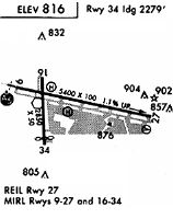
Runways
Runway Summary
| Runways: | 09/27 16/34 H1 |
| Longest Runway: | 09/27 is 5401 ft (1646 m) long |
| Runways with an Instrument Approach: | 09 |
RAL Airport Runway Details
| Runway 09/27 | 5401 ft x 100 ft (1646 m x 30 m) | |
| Runway Length Source: | NGS as of 03/28/2007 | |
| Surface: | Asphalt - Good condition - No special surface treatment | |
| Runway Edge Lights: | Medium Intensity | |
Runway Weight Bearing Capacity (in thousands of pounds) |
||
| Single Wheel Landing Gear: | 48.0 | |
| Dual Wheel Landing Gear: | 70.0 | |
| Dual Tandem Wheel Landing Gear: | 110.0 | |
Runway 09 |
Runway 27 |
|
Elevation: |
760.4 | 818.6 |
Latitude: |
33-57-13.9946N | 33-57-01.9321N |
Longitude: |
117-27-07.0891W | 117-26-04.6412W |
|
Runway True Alignment: |
103 | 283 |
ILS Type: |
ILS | |
Glide Path Angle: |
3.0 degrees | 3.0 degrees |
Traffic Pattern: |
Left | |
Runway Markings Type: |
Precision Instrument | Nonprecision Instrument |
Runway Markings Condition: |
Good | Good |
Object at End: |
GND | |
Object Height: |
37 | |
Distance from End: |
1155 | |
Object Centerline Offset: |
520 ft. right of centerline | |
Visual Glide Slope Indicators: |
4-Light PAPI On Left Side Of Runway | 4-Light PAPI On Left Side Of Runway |
REIL: |
No | No |
Touchdown Lights: |
No | No |
Centerline Lights: |
No | No |
Threshold Crossing Height: |
41 | 40 |
| Runway 16/34 | 2850 ft x 50 ft (869 m x 15 m) | |
| Runway Length Source: | NGS as of 03/28/2007 | |
| Surface: | Asphalt - Good condition - No special surface treatment | |
| Runway Edge Lights: | Medium Intensity | |
Runway Weight Bearing Capacity (in thousands of pounds) |
||
| Single Wheel Landing Gear: | 40.0 | |
| Dual Wheel Landing Gear: | 50.0 | |
| Dual Tandem Wheel Landing Gear: | 80.0 | |
Runway 16 |
Runway 34 |
|
Elevation: |
774.5 | 750.6 |
Latitude: |
33-57-18.5568N | 33-56-50.3748N |
Longitude: |
117-26-55.0968W | 117-26-54.2398W |
|
Runway True Alignment: |
179 | 359 |
Glide Path Angle: |
0.0 degrees | 3.0 degrees |
Traffic Pattern: |
Right | Left |
Runway Markings Type: |
Basic | Basic |
Runway Markings Condition: |
Good | Good |
Object Centerline Offset: |
520 ft. right of centerline | |
Visual Glide Slope Indicators: |
2-Light PAPI On Left Side Of Runway | |
REIL: |
No | No |
Touchdown Lights: |
No | No |
Centerline Lights: |
No | No |
Threshold Crossing Height: |
36 |
| Helipad H1 | 60 ft x 60 ft (18 m x 18 m) | |
| Surface: | Asphalt - Good condition - No special surface treatment | |
| Runway Edge Lights: | Perimeter lights (for helipads) Intensity | |
Helipad H1 |
||
Glide Path Angle: |
0.0 degrees | 0.0 degrees |
Object Centerline Offset: |
520 ft. right of centerline |
Services
Airframe Repair: |
Major |
Powerplant Repair: |
Major |
Bottled Oxygen: |
None |
Bulk Oxygen: |
None |
Fuel Available: |
100LL, Jet A |
Landing Fees: |
No |
Parking: |
Tiedowns available |
Maps & Diagrams
RAL Sectional
Flight Planning
at skyvector.com
at skyvector.com