Location
Latitude: |
39-36-50.0000N (39.613889) |
Longitude: |
110-45-05.8000W (-110.751611) |
Elevation: |
5957.6 feet MSL (1816 m MSL) |
Magnetic Variation: |
10.3 E (as of April 2024 from WMM2020 model) |
Time Zone: |
UTC -7.0 (Standard Time) UTC -6.0 (Daylight Savings Time) |
From City: |
03 N.M. E of Price, Utah |
Found On: |
Denver Chart |
FAA Region: |
ANM |
Contacts
Manager: |
Publicly owned: |
| GARY SPRINGER 3095 AIRPORT ROAD, 3095 EAST AIRPORT ROAD PRICE, UT 84501 435-637-9556 |
CARBON COUNTY 751 E 100 N PRICE, UT 84501 435-636-3201 |
Operations
Airport Status: |
Operational |
Facility Use: |
Public |
Type: |
Airport |
Activation Date: |
09/1941 |
Control tower: |
No |
Attendance (Months/Days/Hours): |
Months/Days/Hours APRIL-OCT/ALL/0800-1800 |
Boundary ARTCC: |
ZLC (Salt Lake City) |
Responsible ARTCC: |
ZLC (Salt Lake City) |
Lighting Schedule: |
SEE RMK |
Segmented Circle Indicator: |
No |
Traffic Pattern Altitude (MSL): |
6958 feet (2121 m) |
NOTAMs Facility: |
PUC |
NOTAM-D Service: |
Yes |
International Airport of Entry: |
No |
Customs Landing Rights: |
No |
Military Landing Rights: |
Yes |
Civil/Military Joint Use: |
No |
Based Aircraft
| Single Engine: | 14 |
Annual Operations (as of 09/28/2023)
| Total Operations: | 5504 | |
| Air Taxi: | 104 | 1.9% |
| GA Local: | 2700 | 49.1% |
| GA Itinerant: | 2700 | 49.1% |
Communications
| CTAF: | 122.800 |
| Unicom: | 122.800 |
| ASOS: | 135.425 (435-637-2790) |
- APCH/DEP CTL SVC PRVDD BY SALT LAKE ARTCC (ZLC) ON FREQS 133.9/370.85 (SUNNYSIDE RCAG).
Fixed Based Operators (FBOs) & Fuel
(Click on a business for detail)
Please help us keep this information up to date. This is a FREE SERVICE just like everything else on Airport Guide! If you see that a business needs to be added, modified, or deleted please fill out our Update Form.
To add, modify, or delete a business click here.
Please help us keep this information up to date. This is a FREE SERVICE just like everything else on Airport Guide! If you see that a business needs to be added, modified, or deleted please fill out our Update Form.
Area Code: 801 |
| Business Name | Frequency | Phone | Fuel Grade |
|---|---|---|---|
| Arrow West Aviation
Update FBO info |
637-9556 | 100LL, Jet A |
Flight Service Stations
| Primary | Alternate | |
| FSS on Field: | N | |
| FSS Name (ID): | Cedar City(CDC) | |
| Frequency: | ||
| Toll Free Phone: | 1-800-WX-BRIEF |
Instrument Procedures / Charts
FAA Terminal Procedures valid from 0901Z 03/21/24 to 0901Z 04/18/24.
There are various types of charts available for an airport. They are listed in the Page Type column. Here is a legend for those types:
APD - Airport Diagram
DP - Departure Procedure Charts
HOT - Hot Spots
IAP - Instrument Approach Procedure Charts
MIN - Minimums
STAR - Standard Terminal Arrival Charts
| Page Type | Page Name | Volume | Action Since Last Cycle |
|---|---|---|---|
| IAP | ILS OR LOC RWY 01 | SW-4 | |
| IAP | RNAV (GPS) RWY 01 | SW-4 | |
| MIN | ALTERNATE MINIMUMS | SW-4 | |
| MIN | TAKEOFF MINIMUMS | SW-4 |
Terminal Procedures are only available for airports in several countries with more being added all the time. If you are looking for a specific country's charts, please send an email to support(at)airportguide.com stating the country name. This will be used to prioritize the implementation.
Navigation Aids (Navaids) near PUC
| Dist (NM) | ID | Morse Code | Name | Type | Freq | True Hdg | Mag Hdg |
|---|---|---|---|---|---|---|---|
| 0.6 | PUC | . _ _ . . . _ _ . _ . | Carbon | VOR-DME | 115.50 | 187 | 177 |
| 43.1 | MTU | _ _ _ . . _ | Myton | VOR-DME | 112.70 | 41 | 31 |
| 57.4 | PVU | . _ _ . . . . _ . . _ | Provo | VOR-DME | 108.40 | 309 | 299 |
| 67.6 | FFU | . . _ . . . _ . . . _ | Fairfield | VORTAC | 116.60 | 306 | 295 |
| 69.4 | OAB | _ _ _ . _ _ . . . | Moab | VOR-DME | 109.80 | 137 | 127 |
| 71.9 | HVE | . . . . . . . _ . | Hanksville | VORTAC | 115.90 | 178 | 168 |
| 73.8 | VEL | . . . _ . . _ . . | Vernal | VOR-DME | 108.20 | 51 | 41 |
| 83.4 | DTA | _ . . _ . _ | Delta | VORTAC | 116.10 | 257 | 246 |
| 88.9 | SLC | . . . . _ . . _ . _ . | Salt Lake City | VOT | 111.00 | 321 | 310 |
| 93.2 | TCH | _ _ . _ . . . . . | Wasatch | VORTAC | 116.80 | 323 | 312 |
| 94.6 | TVY | _ . . . _ _ . _ _ | Tooele | NDB | 371 | 309 | 298 |
| 96.8 | JNC | . _ _ _ _ . _ . _ . | Grand Junction | VOR-DME | 112.40 | 109 | 99 |
Nearby Airports with Fuel
Notices to Airmen (NOTAMS)
Remarks
| A110-1 | FOR CD IF UNA TO CTC ON FSS FREQ, CTC SALT LAKE ARTCC AT 801-320-2568. |
| A110-2 | RWY 15, 20 FT DROP OFF, 200 FT FM THLD. |
| A110-3 | RWY 08, 60 FT DROP OFF, 520 FT FM RWY END. |
| A24 | > 25K LBS $200 RAMP FEE. LNDG FEE WAIVED WITH MNM FUEL PURCHASE. |
| A43-19 | PAPI UNUSBL BYD 3 NM DUE TO TRRN; BYD 9 DEGS RIGHT OF CNTRLN. |
| A52-19 | HIGH VOLTAGE TRANS LINE ON EXTDD CNTRLN. |
| A70-FUEL-10 | 0LL 24 HR SELF SVC FUEL AVBL WITH CREDIT CARD. |
| A81-APT | ACTVT MALSF RWY 01; REIL RWY 19, 08 & 26; PAPI RWY 01 & 19, 08 & 26; HIRL RWY 01/19; MIRL RWY 15/33 - CTAF. |
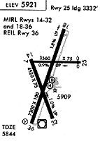
Runways
Runway Summary
| Runways: | 01/19 08/26 15/33 |
| Longest Runway: | 01/19 is 8316 ft (2535 m) long |
| Runways with an Instrument Approach: | 01 |
PUC Airport Runway Details
| Runway 01/19 | 8316 ft x 100 ft (2535 m x 30 m) | |
| Runway Length Source: | 3RD PARTY SURVEY as of 06/05/2015 | |
| Surface: | Asphalt - Excellent condition - Saw-cut or plastic grooved | |
| Runway Pavement Class: | 18 /F/B/X/U | |
| Runway Edge Lights: | High Intensity | |
Runway Weight Bearing Capacity (in thousands of pounds) |
||
| Single Wheel Landing Gear: | 30.0 | |
| Dual Wheel Landing Gear: | 40.0 | |
Runway 01 |
Runway 19 |
|
Elevation: |
5811.7 | 5957.6 |
Latitude: |
39-36-17.7155N | 39-37-35.6868N |
Longitude: |
110-45-18.7701W | 110-44-45.3171W |
|
Runway True Alignment: |
018 | 198 |
ILS Type: |
ILS/DME | |
Glide Path Angle: |
3.0 degrees | 4.0 degrees |
Traffic Pattern: |
Left | Left |
Runway Markings Type: |
Precision Instrument | Basic |
Runway Markings Condition: |
Good | Good |
Visual Glide Slope Indicators: |
4-Light PAPI On Left Side Of Runway | 2-Light PAPI On Left Side Of Runway |
Approach Light System: |
1,400 Foot Medium Intensity Approach Lighting System With Sequenced Flashers | |
REIL: |
Yes | |
Threshold Crossing Height: |
52 | 45 |
| Runway 08/26 | 3151 ft x 75 ft (960 m x 23 m) | |
| Runway Length Source: | 3RD PARTY SURVEY as of 06/05/2015 | |
| Surface: | Asphalt - Excellent condition - No special surface treatment | |
| Runway Pavement Class: | 3 /F/B/Z/U | |
Runway Weight Bearing Capacity (in thousands of pounds) |
||
| Single Wheel Landing Gear: | 12.5 | |
Runway 08 |
Runway 26 |
|
Elevation: |
5859.3 | 5890.5 |
Latitude: |
39-36-54.4719N | 39-36-54.5475N |
Longitude: |
110-45-24.1566W | 110-44-43.9008W |
|
Runway True Alignment: |
090 | 270 |
Glide Path Angle: |
3.0 degrees | 3.0 degrees |
Traffic Pattern: |
Left | Left |
Runway Markings Type: |
Basic | Basic |
Runway Markings Condition: |
Good | Good |
Object at End: |
ROAD | |
Visual Glide Slope Indicators: |
2-Light PAPI On Left Side Of Runway | 2-Light PAPI On Left Side Of Runway |
REIL: |
Yes | Yes |
Threshold Crossing Height: |
37 | 40 |
Threshold Elevation: |
5861.0 | |
Displaced Threshold: |
128 | |
Threshold Latitude: |
39-36-54.4753N | |
Threshold Longitude: |
110-45-22.5167W |
| Runway 15/33 | 4513 ft x 75 ft (1376 m x 23 m) | |
| Runway Length Source: | 3RD PARTY SURVEY as of 06/05/2015 | |
| Surface: | Asphalt - Excellent condition - No special surface treatment | |
| Runway Pavement Class: | 13 /F/B/X/U | |
| Runway Edge Lights: | Medium Intensity | |
Runway Weight Bearing Capacity (in thousands of pounds) |
||
| Single Wheel Landing Gear: | 13.0 | |
Runway 15 |
Runway 33 |
|
Elevation: |
5860.6 | 5812.6 |
Latitude: |
39-36-55.3742N | 39-36-13.8352N |
Longitude: |
110-45-24.2460W | 110-45-03.3150W |
|
Runway True Alignment: |
158 | 338 |
Glide Path Angle: |
0.0 degrees | 0.0 degrees |
Traffic Pattern: |
Left | Left |
Runway Markings Type: |
Basic | Basic |
Runway Markings Condition: |
Fair | Fair |
Object at End: |
ROAD |
Services
Airframe Repair: |
None |
Powerplant Repair: |
None |
Bottled Oxygen: |
None |
Bulk Oxygen: |
None |
Fuel Available: |
100LL |
Landing Fees: |
No |
Parking: |
Tiedowns available |
Other Services: |
Aviation College |
Maps & Diagrams
PUC Sectional
Flight Planning
at skyvector.com
at skyvector.com