Location
Latitude: |
45-12-02.3750N (45.20066) |
Longitude: |
067-33-51.8360W (-67.564399) |
Elevation: |
264.9 feet MSL (81 m MSL) |
Magnetic Variation: |
15.8 W (as of April 2024 from WMM2020 model) |
Time Zone: |
UTC -5.0 (Standard Time) UTC -4.0 (Daylight Savings Time) |
From City: |
02 N.M. S of Princeton, Maine |
Found On: |
Halifax Chart |
FAA Region: |
ANE |
Contacts
Manager: |
Publicly owned: |
| BRAD RICHARD PO BOX 346 PRINCETON, ME 04668 207-214-5144 |
TOWN OF PRINCETON TOWN OFFICES PRINCETON, ME 04668 207-796-2744 |
Operations
Airport Status: |
Operational |
Facility Use: |
Public |
Type: |
Airport |
Activation Date: |
03/1943 |
Control tower: |
No |
Attendance (Months/Days/Hours): |
Months/Days/Hours Unattended |
Boundary ARTCC: |
ZBW (Boston) |
Responsible ARTCC: |
ZBW (Boston) |
Lighting Schedule: |
SEE RMK |
Segmented Circle Indicator: |
Yes |
Traffic Pattern Altitude (MSL): |
1265 feet (386 m) |
NOTAMs Facility: |
BGR |
NOTAM-D Service: |
Yes |
International Airport of Entry: |
No |
Customs Landing Rights: |
Yes |
Military Landing Rights: |
Yes |
Civil/Military Joint Use: |
No |
Based Aircraft
| Single Engine: | 1 |
Annual Operations (as of 08/22/2023)
| Total Operations: | 2330 | |
| Air Taxi: | 80 | 3.4% |
| GA Local: | 700 | 30.0% |
| GA Itinerant: | 1200 | 51.5% |
| Military Aircraft: | 350 | 15.0% |
Communications
| CTAF: | 122.700 |
| Unicom: | 122.700 |
| AWOS-AV: | 122.7 |
- APCH/DEP SVC PRVDD BY BOSTON ARTCC ON FREQ 124.25/290.50 (BANGOR RCAG).
Fixed Based Operators (FBOs) & Fuel
(Click on a business for detail)
Please help us keep this information up to date. This is a FREE SERVICE just like everything else on Airport Guide! If you see that a business needs to be added, modified, or deleted please fill out our Update Form.
To add, modify, or delete a business click here.
Please help us keep this information up to date. This is a FREE SERVICE just like everything else on Airport Guide! If you see that a business needs to be added, modified, or deleted please fill out our Update Form.
Area Code: 207 |
| Business Name | Frequency | Phone | Fuel Grade |
|---|
Flight Service Stations
| Primary | Alternate | |
| FSS on Field: | N | |
| FSS Name (ID): | Bangor(BGR) | |
| Frequency: | ||
| Toll Free Phone: | 1-800-WX-BRIEF |
Instrument Procedures / Charts
FAA Terminal Procedures valid from 0901Z 03/21/24 to 0901Z 04/18/24.
There are various types of charts available for an airport. They are listed in the Page Type column. Here is a legend for those types:
APD - Airport Diagram
DP - Departure Procedure Charts
HOT - Hot Spots
IAP - Instrument Approach Procedure Charts
MIN - Minimums
STAR - Standard Terminal Arrival Charts
| Page Type | Page Name | Volume | Action Since Last Cycle |
|---|---|---|---|
| IAP | RNAV (GPS) RWY 15 | NE-1 | |
| IAP | RNAV (GPS) RWY 33 | NE-1 | |
| MIN | TAKEOFF MINIMUMS | NE-1 |
Terminal Procedures are only available for airports in several countries with more being added all the time. If you are looking for a specific country's charts, please send an email to support(at)airportguide.com stating the country name. This will be used to prioritize the implementation.
Navigation Aids (Navaids) near PNN
| Dist (NM) | ID | Morse Code | Name | Type | Freq | True Hdg | Mag Hdg |
|---|---|---|---|---|---|---|---|
| 9.7 | PNN | . _ _ . _ . _ . | Princeton | DME | 114.3 | 322 | 338 |
| 29.1 | EPM | . . _ _ . _ _ | Eastport | NDB | 260 | 126 | 142 |
| 43.5 | 6E | Grand Manan | NDB | 387 | 131 | 147 | |
| 46.3 | MLT | _ _ . _ . . _ | Millinocket | VOR-DME | 117.90 | 300 | 316 |
| 46.8 | OLD | _ _ _ . _ . . _ . . | Old Town | NDB | 272 | 255 | 271 |
| 49.5 | LNT | . _ . . _ . _ | Milnot | NDB | 344 | 303 | 319 |
| 50.7 | BH | _ . . . . . . . | Surry | NDB | 330 | 218 | 234 |
| 51.6 | HUL | . . . . . . _ . _ . . | Houlton | DME | 116.1 | 347 | 363 |
| 58.4 | IDC | Fredericton | DME | 111.30 | 46 | 62 | |
| 58.4 | BGR | _ . . . _ _ . . _ . | Bangor | VOT | 111.00 | 246 | 262 |
| 59.1 | FC | Fredericton | NDB | 326 | 42 | 58 | |
| 59.6 | BGR | _ . . . _ _ . . _ . | Bangor | VORTAC | 114.80 | 249 | 265 |
| 63.7 | YFC | _ . _ _ . . _ . _ . _ . | Fredericton | VORTAC | 113.00 | 48 | 64 |
| 67.9 | ZST | Alpine | NDB | 397 | 88 | 104 | |
| 72.6 | YSJ | _ . _ _ . . . . _ _ _ | Saint John | VOR-DME | 113.50 | 79 | 95 |
| 74.6 | SJ | Saint John | NDB | 212 | 80 | 96 | |
| 77.7 | BST | _ . . . . . . _ | Belfast | NDB | 278 | 232 | 248 |
| 81.9 | BUP | _ . . . . . _ . _ _ . | Burnham | NDB | 348 | 249 | 265 |
| 85.0 | Y9 | Digby | NDB | 220 | 116 | 132 | |
| 86.7 | PQ | . _ _ . _ _ . _ | Excal | NDB | 278 | 347 | 363 |
Nearby Airports with Fuel
Notices to Airmen (NOTAMS)
Remarks
| A110-2 | WILDLIFE ON & INVOF ARPT. |
| A110-3 | FOR CD CTC BOSTON ARTCC AT 603-879-6859. |
| A30-06/24 | CLSD INDEFLY - PAVEMENT UNUSBL. |
| A42-06 | RWY 06/24 MKD WITH YELLOW CLOSURE AT BOTH ENDS & MID OF RWY. DTHR MARKINGS ARE NOT VSB. |
| A57-24 | DTHR NO LONGER VSB. |
| A58-15 | BRUSH 100-200 FT L AND 75-170 FT R OF RWY. |
| A58-24 | 20-35 FT TREES 20 FT FM THR, 125 FT L & R ACRS APCH. |
| A70-FUEL-10 | 0LL AVBL 24 HRS WITH MAJOR CREDIT CARD. |
| A75 | BRING OWN TIE DOWN ROPES. |
| A81-APT | ACTVT PAPI RWY 15; MIRL RWY 15/33 - CTAF. |
| A82 | AUTOMATED UNICOM; 3 CLICKS. |
| E111 | EXISTED PRIOR TO 1959. |
Runways
Runway Summary
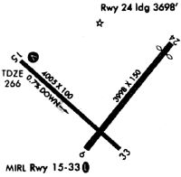
| Runways: | 06/24 15/33 |
| Longest Runway: | 15/33 is 4007 ft (1221 m) long |
| Runways with an Instrument Approach: |
PNN Airport Runway Details
| Runway 06/24 | 3998 ft x 150 ft (1219 m x 46 m) | |
| Runway Length Source: | 3RD PARTY SURVEY as of 06/27/2010 | |
| Surface: | Asphalt - Failed condition - No special surface treatment | |
Runway 06 |
Runway 24 |
|
Elevation: |
238.6 | 245.5 |
Latitude: |
45-11-47.9390N | 45-12-18.8249N |
Longitude: |
067-33-57.3735W | 067-33-22.5973W |
|
Runway True Alignment: |
039 | 219 |
Glide Path Angle: |
0.0 degrees | 0.0 degrees |
Runway Markings Type: |
Numbers Only | Numbers Only |
Runway Markings Condition: |
Poor | Poor |
Object at End: |
TREES | TREES |
Object Height: |
25 | 25 |
Distance from End: |
201 | 201 |
Object Centerline Offset: |
0 ft. left and right of centerline | 0 ft. left and right of centerline |
Threshold Elevation: |
247.9 | |
Displaced Threshold: |
503 | |
Threshold Latitude: |
45-12-14.9379N | |
Threshold Longitude: |
067-33-26.9730W |
| Runway 15/33 | 4007 ft x 75 ft (1221 m x 23 m) | |
| Runway Length Source: | 3RD PARTY SURVEY as of 05/04/2018 | |
| Surface: | Asphalt - Failed condition - No special surface treatment | |
| Runway Edge Lights: | Medium Intensity | |
Runway Weight Bearing Capacity (in thousands of pounds) |
||
| Single Wheel Landing Gear: | 31.0 | |
| Dual Wheel Landing Gear: | 38.0 | |
Runway 15 |
Runway 33 |
|
Elevation: |
263.4 | 252.3 |
Latitude: |
45-12-14.7493N | 45-11-47.9885N |
Longitude: |
067-34-24.2699W | 067-33-43.0493W |
|
Runway True Alignment: |
133 | 313 |
Glide Path Angle: |
3.5 degrees | 0.0 degrees |
Traffic Pattern: |
Left | Left |
Runway Markings Type: |
Nonprecision Instrument | Nonprecision Instrument |
Runway Markings Condition: |
Fair | Fair |
Object at End: |
TREE | |
Object Height: |
3 | |
Distance from End: |
226 | |
Object Centerline Offset: |
0 ft. left and right of centerline | 0 ft. left and right of centerline |
Visual Glide Slope Indicators: |
4-Light PAPI On Left Side Of Runway | |
REIL: |
No | No |
Touchdown Lights: |
No | No |
Centerline Lights: |
No | No |
Threshold Crossing Height: |
44 |
Services
Airframe Repair: |
None |
Powerplant Repair: |
None |
Bottled Oxygen: |
None |
Bulk Oxygen: |
None |
Fuel Available: |
100LL, Jet A+ |
Landing Fees: |
No |
Parking: |
Hangars and tiedowns available |
Maps & Diagrams
PNN Sectional
Flight Planning
at skyvector.com
at skyvector.com