
Location
Latitude: |
40-04-48.3636N (40.080101) |
Longitude: |
116-35-05.9967E (116.584999) |
Elevation: |
116 feet MSL (35 m MSL) |
Magnetic Variation: |
7.7 W (as of April 2024 from WMM2020 model) |
Time Zone: |
UTC +8.0 (Standard Time) UTC +8.0 (Daylight Savings Time) |
Contacts
Manager: |
: |
Operations
Airport Status: |
Operational |
Facility Use: |
Public |
Type: |
Airport |
Traffic Pattern Altitude (MSL): |
1116 feet (340 m) |
Based Aircraft
Annual Operations (as of )
Communications
| BEIJING WEST TWR: | 124.3 |
| RWY 01/19 TWR: | 118.6 |
| BEIJING EAST TWR: | 118.5 |
| BEIJING DEL: | 121.6 |
| BEIJING GND: | 121.7 |
| GND WEST: | 121.9 |
| GND EAST: | 121.7 |
| BEIJING APP AREA 4: | 119.7 |
| BEIJING APP AREA 3: | 120.6 |
| BEIJING APP AREA 2: | 126.1 |
| BEIJING APP AREA 6: | 121.1 |
| BEIJING APP AREA 5: | 127.75 |
| BEIJING APP AREA 1: | 119.6 |
| BEIJING ATIS: | 127.6 |
Fixed Based Operators (FBOs) & Fuel
(Click on a business for detail)
Please help us keep this information up to date. This is a FREE SERVICE just like everything else on Airport Guide! If you see that a business needs to be added, modified, or deleted please fill out our Update Form.
To add, modify, or delete a business click here.
Please help us keep this information up to date. This is a FREE SERVICE just like everything else on Airport Guide! If you see that a business needs to be added, modified, or deleted please fill out our Update Form.
| Business Name | Frequency | Phone | Fuel Grade |
|---|
Flight Service Stations
| Primary | Alternate | |
| FSS on Field: | ||
| FSS Name (ID): | ||
| Frequency: | ||
| Toll Free Phone: |
Instrument Procedures / Charts
Terminal Procedures are only available for airports in several countries with more being added all the time. If you are looking for a specific country's charts, please send an email to support(at)airportguide.com stating the country name. This will be used to prioritize the implementation.
Navigation Aids (Navaids) near PEK
| Dist (NM) | ID | Morse Code | Name | Type | Freq | True Hdg | Mag Hdg |
|---|---|---|---|---|---|---|---|
| 1.1 | O | Capital | NDB | 431 | 22 | 30 | |
| 1.9 | PEK | Beijing | VOR-DME | 114.70 | 159 | 167 | |
| 2.1 | L | Beijing | NDB | 287 | 337 | 345 | |
| 5.8 | SZY | Shaziying | VOR-DME | 117.20 | 282 | 290 | |
| 10.2 | CU | Shahe | NDB | 555 | 285 | 293 | |
| 12.4 | OB | Huairou | NDB | 380 | 348 | 356 | |
| 15.1 | WF | Xiliuhetun | NDB | 395 | 120 | 128 | |
| 16.8 | HUR | Huairou | VOR-DME | 113.60 | 26 | 34 | |
| 31.0 | JR | Liangxiang | NDB | 475 | 226 | 234 | |
| 36.3 | CD | Qingbaikou | NDB | 422 | 263 | 271 | |
| 39.3 | YV | Tanghekou | NDB | 514 | 3 | 11 | |
| 40.3 | LR | Gubeikou | NDB | 215 | 34 | 42 | |
| 49.0 | VM | Shigezhuang | NDB | 280 | 162 | 170 | |
| 53.3 | YK | Dawangzhuang | NDB | 489 | 180 | 188 | |
| 53.3 | VYK | Dawangzhuang | VOR-DME | 112.70 | 180 | 188 | |
| 53.5 | KM | Huailai | NDB | 360 | 290 | 298 | |
| 64.2 | JS | Tianjin | NDB | 452 | 147 | 155 | |
| 64.7 | JB | Zangangzhen | NDB | 403 | 196 | 204 | |
| 65.8 | J | Tianjin | NDB | 517 | 148 | 156 | |
| 68.5 | TAJ | Tianjin | VOR-DME | 112.10 | 148 | 156 |
Nearby Airports with Fuel
| Dist (NM) | Name (Airport IDs) | True Hdg | Mag Hdg | Fuel Grade |
|---|
Notices to Airmen (NOTAMS)
Remarks
No remarks for this landing facility
Runways
Runway Summary
| Runways: | 01/19 18L/36R 18R/36L |
| Longest Runway: | 01/19 is 12500 ft (3810 m) long |
| Runways with an Instrument Approach: |
PEK Airport Runway Details
| Runway 01/19 | 12500 ft x 197 ft (3810 m x 60 m) | |
| Runway Edge Lights: | Yes Intensity | |
Runway 01 |
Runway 19 |
|
Elevation: |
94 | 84 |
Latitude: |
40.058914 | 40.092834 |
Longitude: |
116.617599 | 116.612297 |
|
Runway True Alignment: |
353 | 173 |
Glide Path Angle: |
0.0 degrees | 0.0 degrees |
REIL: |
Yes | Yes |
Threshold Elevation: |
94 | 84 |
| Runway 18L/36R | 12500 ft x 197 ft (3810 m x 60 m) | |
| Runway Edge Lights: | Yes Intensity | |
Runway 18L |
Runway 36R |
|
Elevation: |
110 | 99 |
Latitude: |
40.089359 | 40.055527 |
Longitude: |
116.594833 | 116.600166 |
|
Runway True Alignment: |
173 | 353 |
Glide Path Angle: |
0.0 degrees | 0.0 degrees |
REIL: |
Yes | Yes |
Threshold Elevation: |
110 | 99 |
| Runway 18R/36L | 11302 ft x 164 ft (3445 m x 50 m) | |
| Runway Edge Lights: | Yes Intensity | |
Runway 18R |
Runway 36L |
|
Elevation: |
116 | 107 |
Latitude: |
40.102112 | 40.073479 |
Longitude: |
116.569695 | 116.574165 |
|
Runway True Alignment: |
173 | 353 |
Glide Path Angle: |
0.0 degrees | 0.0 degrees |
REIL: |
Yes | Yes |
Threshold Elevation: |
116 | 107 |
Services
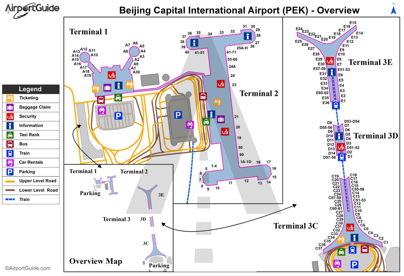
Maps & Diagrams
PEK Sectional
Flight Planning
at skyvector.com
at skyvector.com
