Location
Latitude: |
46-58-09.8560N (46.969404) |
Longitude: |
122-54-09.1610W (-122.902545) |
Elevation: |
207.8 feet MSL (63 m MSL) |
Magnetic Variation: |
15.2 E (as of April 2024 from WMM2020 model) |
Time Zone: |
UTC -8.0 (Standard Time) UTC -7.0 (Daylight Savings Time) |
From City: |
04 N.M. S of Olympia, Washington |
Found On: |
Seattle Chart |
FAA Region: |
ANM |
Contacts
Manager: |
Publicly owned: |
| WARREN HENDRICKSON 7643 OLD HWY 99 SE OLYMPIA, WA 98501 360-528-8074 |
PORT OF OLYMPIA 606 COLUMBIA ST NW, SUITE 300 OLYMPIA, WA 98501-0827 360-528-8000 |
Operations
Airport Status: |
Operational |
Facility Use: |
Public |
Type: |
Airport |
Activation Date: |
12/1937 |
Control tower: |
Yes |
Attendance (Months/Days/Hours): |
Months/Days/Hours ALL/ALL/0800-1700 |
Boundary ARTCC: |
ZSE (Seattle) |
Responsible ARTCC: |
ZSE (Seattle) |
Lighting Schedule: |
SEE RMK |
Segmented Circle Indicator: |
Yes |
Traffic Pattern Altitude (MSL): |
1208 feet (368 m) |
NOTAMs Facility: |
OLM |
NOTAM-D Service: |
Yes |
International Airport of Entry: |
No |
Customs Landing Rights: |
Yes |
Military Landing Rights: |
Yes |
Civil/Military Joint Use: |
No |
Based Aircraft
| Single Engine: | 110 |
| Multi Engine: | 7 |
| Jet Engine: | 2 |
| GA Helicopters: | 18 |
Annual Operations (as of 12/31/2022)
| Total Operations: | 67512 | |
| Air Taxi: | 1216 | 1.8% |
| GA Local: | 37831 | 56.0% |
| GA Itinerant: | 27135 | 40.2% |
| Military Aircraft: | 1330 | 2.0% |
Communications
| CTAF: | 124.400 |
| Unicom: | 122.950 |
| Tower: | OLYMPIA 124.4 254.25 Hrs: 0800-2000 |
| Ground: | 121.6 |
| Approach: | SEATTLE 121.1 121.1 |
| Departure: | SEATTLE 121.1 121.1 |
| ATIS: | 135.725 Hrs: 0800-2000L |
| ASOS: | 135.725 (360-754-0781) |
- EMERG FREQ 121.5 NOT MON AT TOWER
Fixed Based Operators (FBOs) & Fuel
(Click on a business for detail)
Please help us keep this information up to date. This is a FREE SERVICE just like everything else on Airport Guide! If you see that a business needs to be added, modified, or deleted please fill out our Update Form.
To add, modify, or delete a business click here.
Please help us keep this information up to date. This is a FREE SERVICE just like everything else on Airport Guide! If you see that a business needs to be added, modified, or deleted please fill out our Update Form.
Area Code: 360 |
| Business Name | Frequency | Phone | Fuel Grade |
|---|---|---|---|
| Jorgensen Air Service
Website Update FBO info |
Unicom 122.95, Ground 121.6 | 360-754-4043 | 100LL, Jet A |

|
 Exxon |
100LL - 5.70 USD per gallon on 03/22/2018 |
Trucks |
|
|
Exxon |
Jet A - 4.34 USD per gallon on 03/22/2018 |
Trucks Contract fuel discount/ Jet A 500+ gal. 2.80 gal |
| JRW Aircraft Maintenance
Update FBO info |
956-1579 | ||
| Olympic Flight Museum
Update FBO info |
705-3925 | ||
| Pearson Air, Inc.
Update FBO info |
Unicom 123.5 | 786-8333 | 100LL, Jet A |
| Soloy Corporation
Update FBO info |
Unicom 123.45 | 754-7000 |
Flight Service Stations
| Primary | Alternate | |
| FSS on Field: | N | |
| FSS Name (ID): | Seattle(SEA) | |
| Frequency: | ||
| Toll Free Phone: | 1-800-WX-BRIEF |
Instrument Procedures / Charts
FAA Terminal Procedures valid from 0901Z 03/21/24 to 0901Z 04/18/24.
There are various types of charts available for an airport. They are listed in the Page Type column. Here is a legend for those types:
APD - Airport Diagram
DP - Departure Procedure Charts
HOT - Hot Spots
IAP - Instrument Approach Procedure Charts
MIN - Minimums
STAR - Standard Terminal Arrival Charts
| Page Type | Page Name | Volume | Action Since Last Cycle |
|---|---|---|---|
| APD | AIRPORT DIAGRAM | NW-1 | |
| DP | YELM FIVE | NW-1 | |
| HOT | HOT SPOT | NW-1 | |
| IAP | ILS OR LOC RWY 17 | NW-1 | |
| IAP | RNAV (GPS) RWY 17 | NW-1 | |
| IAP | RNAV (GPS) RWY 35 | NW-1 | |
| IAP | VOR RWY 35 | NW-1 | |
| IAP | VOR-A | NW-1 | |
| MIN | ALTERNATE MINIMUMS | NW-1 | |
| MIN | DIVERSE VECTOR AREA | NW-1 | |
| MIN | TAKEOFF MINIMUMS | NW-1 |
Terminal Procedures are only available for airports in several countries with more being added all the time. If you are looking for a specific country's charts, please send an email to support(at)airportguide.com stating the country name. This will be used to prioritize the implementation.
Navigation Aids (Navaids) near OLM
| Dist (NM) | ID | Morse Code | Name | Type | Freq | True Hdg | Mag Hdg |
|---|---|---|---|---|---|---|---|
| 0.1 | OLM | _ _ _ . _ . . _ _ | Olympia | VORTAC | 113.40 | 13 | 358 |
| 14.3 | LAC | . _ . . . _ _ . _ . | Lacomas | NDB | 328 | 80 | 65 |
| 16.3 | GRF | _ _ . . _ . . . _ . | Graye | NDB | 216 | 48 | 33 |
| 18.3 | MNC | _ _ _ . _ . _ . | Mason County | NDB | 348 | 335 | 320 |
| 20.5 | TCM | _ _ . _ . _ _ | Mcchord | TACAN | 109.60 | 58 | 43 |
| 26.6 | CAN | _ . _ . . _ _ . | Carney | NDB | 274 | 5 | 350 |
| 31.9 | PWT | . _ _ . . _ _ _ | Kitsap | NDB | 206 | 10 | 355 |
| 37.0 | SEA | . . . . . _ | Seattle | VORTAC | 116.80 | 40 | 25 |
| 38.1 | SEA | . . . . . _ | Seattle-Tacoma | VOT | 117.50 | 39 | 24 |
| 41.5 | BFI | _ . . . . . _ . . . | Seattle | VOT | 108.60 | 35 | 20 |
| 41.6 | HPK | . . . . . _ _ . _ . _ | Parkk | NDB | 281 | 35 | 20 |
| 42.2 | RNT | . _ . _ . _ | Renton | NDB | 353 | 41 | 26 |
| 44.9 | BF | _ . . . . . _ . | Nolla | NDB | 362 | 27 | 12 |
| 48.8 | LSO | . _ . . . . . _ _ _ | Kelso | NDB | 256 | 180 | 165 |
| 51.1 | HQM | . . . . _ _ . _ _ _ | Hoquiam | VORTAC | 117.70 | 268 | 253 |
| 57.3 | PEN | . _ _ . . _ . | Karpen | NDB | 201 | 209 | 194 |
| 62.4 | PAE | . _ _ . . _ . | Paine | VOR-DME | 110.60 | 23 | 8 |
| 63.1 | AST | . _ . . . _ | Astoria | VOR-DME | 114.00 | 220 | 205 |
| 63.3 | AST | . _ . . . _ | Fort Stevens | FAN MARKER | 224 | 209 | |
| 73.0 | AW | . _ . _ _ | Waton | NDB | 382 | 24 | 9 |
Nearby Airports with Fuel
Notices to Airmen (NOTAMS)
Remarks
| A110-5 | TWY LGTS ON TWY W, A, L, AND B. |
| A110-6 | AIRPORT FIELD CONDITIONS UNMONITORED 1700 LCL - 0700 LCL. |
| A110-7 | EMERG FREQ 121.5 NOT MNT AT TWR. |
| A110-8 | FOR CD WHEN ATCT IS CLSD CTC SEATTLE APCH AT 206-214-4723. |
| A81-APT | WHEN ATCT CLSD ACTVT HIRL RY 17/35; MALSR 17; REIL RY 35, TWY LGTS & DIRECTIONAL SIGNAGE - CTAF. PAPI RYS 17 & 35 OPER CONT. |
| E111 | ESTABD PRIOR TO 15 MAY 1959. |
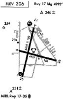
Runways
Runway Summary
| Runways: | 08/26 17/35 |
| Longest Runway: | 17/35 is 5500 ft (1676 m) long |
| Runways with an Instrument Approach: | 17 |
OLM Airport Runway Details
| Runway 08/26 | 4157 ft x 150 ft (1267 m x 46 m) | |
| Surface: | Asphalt - Good condition - No special surface treatment | |
Runway Weight Bearing Capacity (in thousands of pounds) |
||
| Single Wheel Landing Gear: | 30.0 | |
Runway 08 |
Runway 26 |
|
Elevation: |
194.1 | 204.1 |
Latitude: |
46-58-16.7640N | 46-58-07.0640N |
Longitude: |
122-54-28.7370W | 122-53-30.4950W |
|
Runway True Alignment: |
104 | 284 |
Glide Path Angle: |
0.0 degrees | 0.0 degrees |
Traffic Pattern: |
Right | Left |
Runway Markings Type: |
Basic | Basic |
Runway Markings Condition: |
Good | Good |
Object at End: |
TREES | TREE |
Object Height: |
58 | 107 |
Distance from End: |
1360 | 950 |
Object Centerline Offset: |
325 ft. left of centerline | 207 ft. right of centerline |
| Runway 17/35 | 5500 ft x 150 ft (1676 m x 46 m) | |
| Runway Length Source: | OWNER as of 11/21/2005 | |
| Surface: | Asphalt - Good condition - Saw-cut or plastic grooved | |
| Runway Edge Lights: | High Intensity | |
Runway Weight Bearing Capacity (in thousands of pounds) |
||
| Single Wheel Landing Gear: | 75.0 | |
| Dual Wheel Landing Gear: | 94.0 | |
| Dual Tandem Wheel Landing Gear: | 142.0 | |
Runway 17 |
Runway 35 |
|
Elevation: |
196.6 | 202.8 |
Latitude: |
46-58-34.9200N | 46-57-41.6800N |
Longitude: |
122-54-08.6000W | 122-54-24.1500W |
|
Runway True Alignment: |
191 | 011 |
ILS Type: |
ILS | |
Glide Path Angle: |
3.0 degrees | 3.0 degrees |
Traffic Pattern: |
Left | Right |
Runway Markings Type: |
Precision Instrument | Nonprecision Instrument |
Runway Markings Condition: |
Poor | Poor |
Object Centerline Offset: |
325 ft. left of centerline | 207 ft. right of centerline |
Visual Glide Slope Indicators: |
4-Light PAPI On Left Side Of Runway | 4-Light PAPI On Left Side Of Runway |
Approach Light System: |
1,400 Foot Medium Intensity Approach Lighting System With Runway Alignment Indicator Lights | |
REIL: |
Yes | |
Threshold Crossing Height: |
54 | 50 |
Services
Airframe Repair: |
None |
Powerplant Repair: |
None |
Bottled Oxygen: |
None |
Bulk Oxygen: |
None |
Fuel Available: |
100LL |
Landing Fees: |
Yes |
Parking: |
Tiedowns available |
Maps & Diagrams
OLM Sectional
Flight Planning
at skyvector.com
at skyvector.com