Location
Latitude: |
38-40-25.9550N (38.673876) |
Longitude: |
121-52-19.4780W (-121.872077) |
Elevation: |
125.0 feet MSL (38 m MSL) |
Magnetic Variation: |
13.2 E (as of April 2024 from WMM2020 model) |
Time Zone: |
UTC -8.0 (Standard Time) UTC -7.0 (Daylight Savings Time) |
From City: |
04 N.M. W of Woodland, California |
Found On: |
San Francisco Chart |
FAA Region: |
AWP |
Contacts
Manager: |
Privately owned: |
| MILTON B. WATTS 17992 COUNTY ROAD 94B WOODLAND, CA 95695 530-867-6652 |
WATTS-WOODLAND AIRPORT INC. 17992 COUNTY ROAD 94B WOODLAND, CA 95695 530-867-6652 |
Operations
Airport Status: |
Operational |
Facility Use: |
Public |
Type: |
Airport |
Activation Date: |
07/1940 |
Control tower: |
No |
Attendance (Months/Days/Hours): |
Months/Days/Hours OCT-APR/ALL/0800-1700 |
Boundary ARTCC: |
ZOA (Oakland) |
Responsible ARTCC: |
ZOA (Oakland) |
Lighting Schedule: |
SEE RMK |
Segmented Circle Indicator: |
No |
Traffic Pattern Altitude (MSL): |
1125 feet (343 m) |
NOTAMs Facility: |
RIU |
NOTAM-D Service: |
Yes |
International Airport of Entry: |
No |
Customs Landing Rights: |
No |
Military Landing Rights: |
No |
Civil/Military Joint Use: |
No |
Based Aircraft
| Single Engine: | 54 |
| Multi Engine: | 2 |
Annual Operations (as of 02/23/2022)
| Total Operations: | 23000 | |
| Air Taxi: | 3000 | 13.0% |
| GA Local: | 10000 | 43.5% |
| GA Itinerant: | 10000 | 43.5% |
Communications
| CTAF: | 122.800 |
| Unicom: | 122.800 |
| Approach: | TRAVIS 126.6 126.6 |
| Departure: | TRAVIS 126.6 126.6 |
Fixed Based Operators (FBOs) & Fuel
(Click on a business for detail)
Please help us keep this information up to date. This is a FREE SERVICE just like everything else on Airport Guide! If you see that a business needs to be added, modified, or deleted please fill out our Update Form.
To add, modify, or delete a business click here.
Please help us keep this information up to date. This is a FREE SERVICE just like everything else on Airport Guide! If you see that a business needs to be added, modified, or deleted please fill out our Update Form.
Area Code: 530 |
| Business Name | Frequency | Phone | Fuel Grade |
|---|---|---|---|
| Woodland Aviation
Update FBO info |
662-9631 | 100LL, Jet A |
Flight Service Stations
| Primary | Alternate | |
| FSS on Field: | N | |
| FSS Name (ID): | Rancho Murieta(RIU) | |
| Frequency: | ||
| Toll Free Phone: | 1-800-WX-BRIEF |
Instrument Procedures / Charts
FAA Terminal Procedures valid from 0901Z 03/21/24 to 0901Z 04/18/24.
There are various types of charts available for an airport. They are listed in the Page Type column. Here is a legend for those types:
APD - Airport Diagram
DP - Departure Procedure Charts
HOT - Hot Spots
IAP - Instrument Approach Procedure Charts
MIN - Minimums
STAR - Standard Terminal Arrival Charts
| Page Type | Page Name | Volume | Action Since Last Cycle |
|---|---|---|---|
| IAP | RNAV (GPS) RWY 36 | SW-2 | |
| MIN | TAKEOFF MINIMUMS | SW-2 |
Terminal Procedures are only available for airports in several countries with more being added all the time. If you are looking for a specific country's charts, please send an email to support(at)airportguide.com stating the country name. This will be used to prioritize the implementation.
Navigation Aids (Navaids) near O41
| Dist (NM) | ID | Morse Code | Name | Type | Freq | True Hdg | Mag Hdg |
|---|---|---|---|---|---|---|---|
| 13.2 | SMF | . . . _ _ . . _ . | Sacramento Intl | VOT | 111.40 | 85 | 72 |
| 20.0 | TZZ | _ _ _ . . _ _ . . | Travis | VOR | 116.40 | 171 | 158 |
| 20.3 | SAC | . . . . _ _ . _ . | Sacramento Executive | VOT | 111.40 | 118 | 105 |
| 20.4 | SAC | . . . . _ _ . _ . | Sacramento | VORTAC | 115.20 | 132 | 119 |
| 21.9 | MCC | _ _ _ . _ . _ . _ . | Mc Clellan | VOR-DME | 109.20 | 90 | 77 |
| 24.9 | ILA | . . . _ . . . _ | Williams | VORTAC | 114.40 | 343 | 330 |
| 25.9 | SUU | . . . . . _ . . _ | Travis | TACAN | 116.60 | 187 | 174 |
| 29.1 | MYV | _ _ _ . _ _ . . . _ | Marysville | VOR-DME | 110.80 | 28 | 15 |
| 32.2 | MY | _ _ _ . _ _ | Halow | NDB | 222 | 22 | 9 |
| 34.2 | BAB | _ . . . . _ _ . . . | Beale | TACAN | 108.60 | 35 | 22 |
| 37.9 | SGD | . . . _ _ . _ . . | Scaggs Island | VORTAC | 112.10 | 218 | 205 |
| 38.4 | CC | _ . _ . _ . _ . | Kanan | NDB | 335 | 191 | 178 |
| 38.6 | CCR | _ . _ . _ . _ . . _ . | Concord | VOR-DME | 117.00 | 192 | 179 |
| 41.9 | MXW | _ _ _ . . _ . _ _ | Maxwell | VORTAC | 110.00 | 337 | 324 |
| 45.1 | STS | . . . _ . . . | Santa Rosa | DME | 116.15 | 257 | 244 |
| 52.7 | HNW | . . . . _ . . _ _ | Hangtown | VOR-DME | 115.50 | 86 | 73 |
| 54.4 | LIN | . _ . . . . _ . | Linden | VOR-DME | 114.80 | 131 | 118 |
| 57.9 | SAU | . . . . _ . . _ | Sausalito | VOR-DME | 116.20 | 212 | 199 |
| 58.9 | PYE | . _ _ . _ . _ _ . | Point Reyes | VOR-DME | 113.70 | 233 | 220 |
| 59.2 | OAK | _ _ _ . _ _ . _ | Oakland | VOR-DME | 116.80 | 196 | 183 |
Nearby Airports with Fuel
Notices to Airmen (NOTAMS)
Remarks
| A110*G | THIS AIRPORT HAS BEEN SURVEYED BY THE NATIONAL GEODETIC SURVEY. |
| A110-2 | TWIN ENGINE ACFT BACK TAXI ON RY. |
| A110-3 | RY 18 UNLGTD 60 FT TREES HIGHER THAN POLE MOUNTED OBSTN LGTS. |
| A110-4 | FOR CD CTC OAKLAND ARTCC AT 510-745-3380. |
| A35-18/36 | GROSS PAVEMENT STRENGTH PRVDD BY MGR; 12000 LBS. |
| A42-18 | SVRLY FADED RWY MRKGS. |
| A42-36 | SVRLY FADED RWY MRKGS. |
| A57-18 | RWY 18 APCH RATIO 34:1 TO DSPLCD THLD. |
| A57-36 | RY 36 APCH RATIO 34:1 TO DSPLCD THLD. |
| A58-18 | +15 FT ROAD 125 FT FM EOR AND +20 FT BUSHES AND TREE 100 FT RIGHT 75 FT FM EOR. |
| A58-36 | RWY 36 +4' FENCE 55' & ROAD 80' FROM THR. |
| A70-FUEL-10 | 0LL FUEL 24 HRS WITH CREDIT CARD. |
| A81-APT | ACTVT MIRL RY 18/36 - CTAF. |
| E111 | ESTABD PRIOR TO 15 MAY 1959. |
| E147 | TPA FOR TURBINE ACFT 1500 FT AGL; TPA FOR OTHER ACFT 1000 FT AGL. |
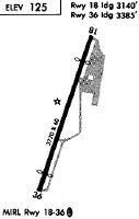
Runways
Runway Summary
| Runways: | 18/36 |
| Longest Runway: | 18/36 is 3759 ft (1146 m) long |
| Runways with an Instrument Approach: |
O41 Airport Runway Details
| Runway 18/36 | 3759 ft x 60 ft (1146 m x 18 m) | |
| Surface: | Asphalt - Fair condition - No special surface treatment | |
| Runway Edge Lights: | Medium Intensity | |
Runway Weight Bearing Capacity (in thousands of pounds) |
||
| Single Wheel Landing Gear: | 12.0 | |
Runway 18 |
Runway 36 |
|
Elevation: |
107.0 | 124.0 |
Latitude: |
38-40-43.4900N | 38-40-08.3980N |
Longitude: |
121-52-11.7200W | 121-52-27.3160W |
|
Runway True Alignment: |
199 | 019 |
Glide Path Angle: |
0.0 degrees | 0.0 degrees |
Runway Markings Type: |
Basic | Basic |
Runway Markings Condition: |
Poor | Poor |
Object at End: |
TREES | ANT |
Object Height: |
36 | 20 |
Distance from End: |
600 | 300 |
Object Centerline Offset: |
209 ft. right of centerline | 100 ft. right of centerline |
REIL: |
No | No |
Centerline Lights: |
No | No |
Threshold Elevation: |
113.0 | 125.0 |
Displaced Threshold: |
630 | 385 |
Threshold Latitude: |
38-40-37.6100N | 38-40-11.9900N |
Threshold Longitude: |
121-52-14.3400W | 121-52-25.7200W |
Declared Distances |
||
Take Off Run Avbl. (TORA): |
3759 | 3759 |
Take Off Distance Avbl. (TODA): |
3759 | 3759 |
Actual Stop Dist. Avbl. (ASDA): |
3559 | 3629 |
Landing Dist. Avbl. (LDA): |
2929 | 3244 |
Services
Airframe Repair: |
Major |
Powerplant Repair: |
Major |
Bottled Oxygen: |
High Pressure / Low Pressure |
Bulk Oxygen: |
High Pressure / Low Pressure |
Fuel Available: |
100LL, Jet A, Jet A-1 |
Landing Fees: |
No |
Parking: |
Hangars and tiedowns available |
Maps & Diagrams
O41 Sectional
Flight Planning
at skyvector.com
at skyvector.com