Location
Latitude: |
36-48-01.1000N (36.800306) |
Longitude: |
105-35-51.0000W (-105.5975) |
Elevation: |
7689.6 feet MSL (2344 m MSL) |
Magnetic Variation: |
7.7 E (as of April 2024 from WMM2020 model) |
Time Zone: |
UTC -7.0 (Standard Time) UTC -6.0 (Daylight Savings Time) |
From City: |
06 N.M. N of Questa, New Mexico |
Found On: |
Denver Chart |
FAA Region: |
ASW |
Contacts
Manager: |
Publicly owned: |
| DONALD CASAUS PO BOX 260 QUESTA, NM 87556 575-613-2853 |
VILLAGE OF QUESTA PO BOX 260 QUESTA, NM 87556 575-586-0694 |
Operations
Airport Status: |
Operational |
Facility Use: |
Public |
Type: |
Airport |
Activation Date: |
03/1991 |
Control tower: |
No |
Attendance (Months/Days/Hours): |
Months/Days/Hours Unattended |
Boundary ARTCC: |
ZDV (Denver) |
Responsible ARTCC: |
ZDV (Denver) |
Lighting Schedule: |
SEE RMK |
Segmented Circle Indicator: |
Yes |
Traffic Pattern Altitude (MSL): |
8690 feet (2649 m) |
NOTAMs Facility: |
ABQ |
NOTAM-D Service: |
Yes |
Based Aircraft
Annual Operations (as of 04/23/2022)
| Total Operations: | 200 | |
| GA Itinerant: | 200 | 100.0% |
Communications
| CTAF: | 122.900 |
| AWOS-3: | 118.2 (575-586-2019) |
Fixed Based Operators (FBOs) & Fuel
(Click on a business for detail)
Please help us keep this information up to date. This is a FREE SERVICE just like everything else on Airport Guide! If you see that a business needs to be added, modified, or deleted please fill out our Update Form.
To add, modify, or delete a business click here.
Please help us keep this information up to date. This is a FREE SERVICE just like everything else on Airport Guide! If you see that a business needs to be added, modified, or deleted please fill out our Update Form.
Area Code: 505 |
| Business Name | Frequency | Phone | Fuel Grade |
|---|
Flight Service Stations
| Primary | Alternate | |
| FSS on Field: | N | |
| FSS Name (ID): | Albuquerque(ABQ) | |
| Frequency: | ||
| Toll Free Phone: | 1-800-WX-BRIEF |
Instrument Procedures / Charts
Terminal Procedures are only available for airports in several countries with more being added all the time. If you are looking for a specific country's charts, please send an email to support(at)airportguide.com stating the country name. This will be used to prioritize the implementation.
Navigation Aids (Navaids) near N24
| Dist (NM) | ID | Morse Code | Name | Type | Freq | True Hdg | Mag Hdg |
|---|---|---|---|---|---|---|---|
| 18.8 | TAS | _ . _ . . . | Taos | VORTAC | 115.80 | 232 | 224 |
| 34.5 | ALS | . _ . _ . . . . . | Alamosa | VORTAC | 113.90 | 342 | 334 |
| 39.5 | CIM | _ . _ . . . _ _ | Cimarron | VORTAC | 116.40 | 117 | 110 |
| 67.7 | TAD | _ . _ _ . . | Trinidad | NDB | 329 | 62 | 55 |
| 72.1 | FTI | . . _ . _ . . | Fort Union | VORTAC | 117.30 | 161 | 154 |
| 78.9 | SAF | . . . . _ . . _ . | Santa Fe | VORTAC | 110.60 | 196 | 188 |
| 79.2 | SG | . . . _ _ . | Doman | NDB | 341 | 199 | 191 |
| 99.5 | TBE | _ _ . . . . | Tobe | VOR-DME | 114.05 | 73 | 66 |
Nearby Airports with Fuel
| Dist (NM) | Name (Airport IDs) | True Hdg | Mag Hdg | Fuel Grade |
|---|---|---|---|---|
| 21.2 | Taos Regional Airport (TSM KSKX SKX) |
189 | 181 | 100LL, Jet A-1+ |
| 27.1 | Angel Fire Airport (AXX KAXX AXX) |
146 | 139 | 100LL, Jet A+ |
| 40.2 | San Luis Valley Regional/Bergman Field Airport (ALS KALS ALS) |
341 | 333 | 100LL, Jet A |
| 48.7 | Monte Vista Municipal Airport (KMVI MVI) |
334 | 326 | 100LL |
| 51.7 | Cuchara Valley At La Veta Airport (07V) |
32 | 25 | 100LL, Jet A |
| 52.8 | Raton Municipal/Crews Field Airport (RTN KRTN RTN) |
93 | 86 | 100LL, Jet A-1+ |
| 62.9 | Leach Airport (1V8) |
340 | 332 | 100LL |
| 64.1 | Los Alamos Airport (LAM KLAM LAM) |
210 | 202 | 100LL |
| 66.2 | Perry Stokes Airport (TAD KTAD TAD) |
65 | 58 | 100LL, Jet A |
| 66.3 | Spanish Peaks Airfield Airport (4V1) |
35 | 28 | 100LL, Jet A |
| 72.2 | Las Vegas Municipal Airport (LVS KLVS LVS) |
162 | 155 | 100LL, Jet A-1 |
| 74.9 | Santa Fe Regional Airport (SAF KSAF SAF) |
198 | 190 | 100LL, Jet A, Jet A+ |
| 75.7 | Stevens Field Airport (PGO KPSO PSO) |
293 | 285 | 100LL, Jet A |
Notices to Airmen (NOTAMS)
Remarks
| A110*G | THIS AIRPORT HAS BEEN SURVEYED BY THE NATIONAL GEODETIC SURVEY. |
| A110-1 | ELK ON & INVOF ARPT. |
| A110-2 | ACES ON & OFF ARPT - VILLAGE OFC 575-586-0694 OR GATE CODE 7670. |
| A110-4 | MTS SW & E. |
| A110-5 | FOR CD CTC DENVER ARTCC AT 303-651-4257. |
| A16 | EMERG - 575-613-2855. |
| A30-17/35 | RWY 17 CALM WIND RWY. |
| A42-17 | MARKINGS FADED. |
| A42-35 | MARKINGS FADED. |
| A58-17 | 1 - 3 FT BRUSH 0 - 200 FT FM THR 80 FT L & R. |
| A81-APT | ACTVT REIL 17 & 35; PAPI RWY 17 & 35; MIRL RWY 17/35 - 123.6. |
Runways
Runway Summary
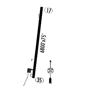
| Runways: | 17/35 |
| Longest Runway: | 17/35 is 6861 ft (2091 m) long |
| Runways with an Instrument Approach: |
N24 Airport Runway Details
| Runway 17/35 | 6861 ft x 75 ft (2091 m x 23 m) | |
| Surface: | Asphalt - Good condition - No special surface treatment | |
| Runway Pavement Class: | 3 /F/D/Y/T | |
| Runway Edge Lights: | Medium Intensity | |
Runway Weight Bearing Capacity (in thousands of pounds) |
||
| Single Wheel Landing Gear: | 12.5 | |
Runway 17 |
Runway 35 |
|
Elevation: |
7666.7 | 7689.6 |
Latitude: |
36-48-34.9530N | 36-47-27.1430N |
Longitude: |
105-35-50.8990W | 105-35-51.0020W |
|
Runway True Alignment: |
180 | 000 |
Glide Path Angle: |
3.0 degrees | 3.0 degrees |
Runway Markings Type: |
Basic | Basic |
Runway Markings Condition: |
Fair | Fair |
Visual Glide Slope Indicators: |
4-Light PAPI On Right Side Of Runway | 4-Light PAPI On Left Side Of Runway |
REIL: |
Yes | Yes |
Threshold Crossing Height: |
40 | 40 |
Services
Airframe Repair: |
Minor |
Powerplant Repair: |
Minor |
Bottled Oxygen: |
None |
Bulk Oxygen: |
High Pressure |
Fuel Available: |
100LL, Jet A |
Landing Fees: |
No |
Parking: |
Hangars and tiedowns available |
Other Services: |
Plane washing |
Maps & Diagrams
N24 Sectional
Flight Planning
at skyvector.com
at skyvector.com