Location
Latitude: |
41-08-15.7000N (41.137694) |
Longitude: |
075-22-48.2000W (-75.380056) |
Elevation: |
1915.2 feet MSL (584 m MSL) |
Magnetic Variation: |
12 W (as of April 2024 from WMM2020 model) |
Time Zone: |
UTC -5.0 (Standard Time) UTC -4.0 (Daylight Savings Time) |
From City: |
02 N.M. NW of Mount Pocono, Pennsylvania |
Found On: |
New York Chart |
FAA Region: |
AEA |
Contacts
Manager: |
Publicly owned: |
| JUSTIN KLEIN 188 AIRPORT DR TOBYHANNA, PA 18466 (570) 839-0258 |
POCONO MTNS MUNI ARPT AUTH 188 AIRPORT DR TOBYHANNA, PA 18466 570-839-0258 |
Operations
Airport Status: |
Operational |
Facility Use: |
Public |
Type: |
Airport |
Activation Date: |
07/1938 |
Control tower: |
No |
Attendance (Months/Days/Hours): |
Months/Days/Hours ALL/ALL/0700-1700 |
Boundary ARTCC: |
ZNY (New York) |
Responsible ARTCC: |
ZNY (New York) |
Lighting Schedule: |
SEE RMK |
Segmented Circle Indicator: |
Yes |
Traffic Pattern Altitude (MSL): |
2915 feet (888 m) |
NOTAMs Facility: |
MPO |
NOTAM-D Service: |
Yes |
International Airport of Entry: |
No |
Customs Landing Rights: |
No |
Military Landing Rights: |
Yes |
Civil/Military Joint Use: |
No |
Based Aircraft
| Single Engine: | 40 |
| Multi Engine: | 6 |
| Jet Engine: | 1 |
| GA Helicopters: | 4 |
Annual Operations (as of 10/14/2022)
| Total Operations: | 22300 | |
| GA Local: | 15500 | 69.5% |
| GA Itinerant: | 6500 | 29.1% |
| Military Aircraft: | 300 | 1.3% |
Communications
| CTAF: | 122.700 |
| Unicom: | 122.700 |
| Clearance Del.: | 125.3 125.3 125.3 |
| Approach: | WILKES-BARRE |
| Departure: | WILKES-BARRE |
| ASOS: | 120.275 (570-839-1584) |
Fixed Based Operators (FBOs) & Fuel
(Click on a business for detail)
Please help us keep this information up to date. This is a FREE SERVICE just like everything else on Airport Guide! If you see that a business needs to be added, modified, or deleted please fill out our Update Form.
To add, modify, or delete a business click here.
Please help us keep this information up to date. This is a FREE SERVICE just like everything else on Airport Guide! If you see that a business needs to be added, modified, or deleted please fill out our Update Form.
Area Code: 570 |
| Business Name | Frequency | Phone | Fuel Grade |
|---|---|---|---|
| Moyer Aviation
Update FBO info |
Unicom 122.7 | 839-7161 | 100LL, Jet A |
Flight Service Stations
| Primary | Alternate | |
| FSS on Field: | N | |
| FSS Name (ID): | Williamsport(IPT) | |
| Frequency: | ||
| Toll Free Phone: | 1-800-WX-BRIEF |
Instrument Procedures / Charts
FAA Terminal Procedures valid from 0901Z 03/21/24 to 0901Z 04/18/24.
There are various types of charts available for an airport. They are listed in the Page Type column. Here is a legend for those types:
APD - Airport Diagram
DP - Departure Procedure Charts
HOT - Hot Spots
IAP - Instrument Approach Procedure Charts
MIN - Minimums
STAR - Standard Terminal Arrival Charts
| Page Type | Page Name | Volume | Action Since Last Cycle |
|---|---|---|---|
| IAP | RNAV (GPS) RWY 05 | NE-4 | |
| IAP | RNAV (GPS) RWY 13 | NE-4 | |
| IAP | RNAV (GPS) RWY 31 | NE-4 | |
| IAP | VOR/DME RWY 13 | NE-4 | |
| MIN | ALTERNATE MINIMUMS | NE-4 | |
| MIN | TAKEOFF MINIMUMS | NE-4 |
Terminal Procedures are only available for airports in several countries with more being added all the time. If you are looking for a specific country's charts, please send an email to support(at)airportguide.com stating the country name. This will be used to prioritize the implementation.
Navigation Aids (Navaids) near MPO
| Dist (NM) | ID | Morse Code | Name | Type | Freq | True Hdg | Mag Hdg |
|---|---|---|---|---|---|---|---|
| 16.2 | LVZ | . _ . . . . . _ _ _ . . | Wilkes-Barre | VORTAC | 111.60 | 300 | 312 |
| 20.8 | LHY | . _ . . . . . . _ . _ _ | Lake Henry | VORTAC | 110.80 | 347 | 359 |
| 24.6 | STW | . . . _ . _ _ | Stillwater | VOR-DME | 109.60 | 110 | 122 |
| 24.9 | FJC | . . _ . . _ _ _ _ . _ . | Allentown | VORTAC | 117.50 | 187 | 199 |
| 32.5 | BWZ | _ . . . . _ _ _ _ . . | Broadway | VOR-DME | 114.20 | 128 | 140 |
| 35.1 | HZL | . . . . _ _ . . . _ . . | Hazleton | VOR | 109.40 | 254 | 266 |
| 36.1 | ETX | . _ _ . . _ | East Texas | VOR-DME | 110.20 | 202 | 214 |
| 38.3 | SAX | . . . . _ _ . . _ | Sparta | VORTAC | 115.70 | 96 | 108 |
| 39.1 | HUO | . . . . . . _ _ _ _ | Huguenot | VOR-DME | 116.10 | 65 | 77 |
| 42.9 | UKT | . . _ _ . _ _ | Quakertown | NDB | 208 | 174 | 186 |
| 44.1 | SBJ | . . . _ . . . . _ _ _ | Solberg | VOR-DME | 112.90 | 138 | 150 |
| 44.4 | MS | _ _ . . . | Monga | NDB | 359 | 31 | 43 |
| 49.2 | CAT | _ . _ . . _ _ | Chatham | NDB | 254 | 118 | 130 |
| 55.5 | PTW | . _ _ . _ . _ _ | Pottstown | VORTAC | 116.50 | 188 | 200 |
| 55.6 | HNK | . . . . _ . _ . _ | Hancock | VOR-DME | 116.80 | 2 | 14 |
| 56.0 | SW | . . . . _ _ | Neely | NDB | 335 | 67 | 79 |
| 57.3 | ARD | . _ . _ . _ . . | Yardley | VOR-DME | 108.20 | 157 | 169 |
| 58.5 | MIP | _ _ . . . _ _ . | Milton | VORTAC | 109.20 | 263 | 275 |
| 60.0 | TE | _ . | Torby | NDB | 214 | 109 | 121 |
| 60.0 | EWR | . . _ _ . _ . | Maryann | FAN MARKER | 115 | 127 |
Nearby Airports with Fuel
Notices to Airmen (NOTAMS)
Remarks
| A110-1 | BIRDS, DEER & OTHER WILDLIFE ON & INVOF ARPT. |
| A110-2 | RWY 31 VFR DEP: FLY HDG 310 TILL CROSSING INTERSTATE 380, THEN PROCEED ON CRS AVOIDING OVERFLIGHT OF HOMES SW OF RWY 13-31. |
| A110-3 | FOR SVC AFT HRS CALL 570-807-8966. |
| A43-31 | VGSI AND RNAV GLIDEPATH NOT COINCIDENT. |
| A57-13 | RWY 13 27:1 SLOPE TO DTHR |
| A70-FUEL-10 | 0LL 24 HR SELF SVC 100LL AVAIL. |
| A81-APT | ACTVT REIL RWY 05, 13, 23 & 31; PAPI RWY 05, 13, 23 & 31; MIRL RWY 05/23 & 13/31 - CTAF. |
| A82 | UNICOM 0800-DUSK DLY. |
Runways
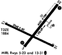
Runway Summary
| Runways: | 05/23 13/31 |
| Longest Runway: | 13/31 is 5001 ft (1524 m) long |
| Runways with an Instrument Approach: |
MPO Airport Runway Details
| Runway 05/23 | 3999 ft x 100 ft (1219 m x 30 m) | |
| Runway Length Source: | 3RD PARTY SURVEY as of 08/11/2014 | |
| Surface: | Asphalt - Good condition - No special surface treatment | |
| Runway Edge Lights: | Medium Intensity | |
Runway Weight Bearing Capacity (in thousands of pounds) |
||
| Single Wheel Landing Gear: | 30.0 | |
| Dual Wheel Landing Gear: | 45.0 | |
| Dual Tandem Wheel Landing Gear: | 70.0 | |
Runway 05 |
Runway 23 |
|
Elevation: |
1874.7 | 1915.2 |
Latitude: |
41-08-02.5669N | 41-08-34.2387N |
Longitude: |
075-22-53.5718W | 075-22-22.3356W |
|
Runway True Alignment: |
037 | 217 |
Glide Path Angle: |
4.0 degrees | 4.0 degrees |
Traffic Pattern: |
Left | Left |
Runway Markings Type: |
Nonprecision Instrument | Nonprecision Instrument |
Runway Markings Condition: |
Good | Good |
Object at End: |
TREES | ROAD |
Object Height: |
23 | 37 |
Object Marked/Lighted?: |
Lighted | |
Distance from End: |
593 | 733 |
Object Centerline Offset: |
148 ft. left of centerline | 0 ft. left and right of centerline |
Visual Glide Slope Indicators: |
2-Light PAPI On Left Side Of Runway | 2-Light PAPI On Left Side Of Runway |
REIL: |
Yes | Yes |
Threshold Crossing Height: |
43 | 53 |
| Runway 13/31 | 5001 ft x 75 ft (1524 m x 23 m) | |
| Runway Length Source: | 3RD PARTY SURVEY as of 08/11/2014 | |
| Surface: | Asphalt - Good condition - No special surface treatment | |
| Runway Edge Lights: | Medium Intensity | |
Runway Weight Bearing Capacity (in thousands of pounds) |
||
| Single Wheel Landing Gear: | 30.0 | |
| Dual Wheel Landing Gear: | 45.0 | |
Runway 13 |
Runway 31 |
|
Elevation: |
1884.9 | 1878.2 |
Latitude: |
41-08-24.0498N | 41-08-03.0534N |
Longitude: |
075-23-25.9461W | 075-22-26.7880W |
|
Runway True Alignment: |
115 | 295 |
Glide Path Angle: |
3.0 degrees | 3.5 degrees |
Traffic Pattern: |
Left | Left |
Runway Markings Type: |
Nonprecision Instrument | Nonprecision Instrument |
Runway Markings Condition: |
Good | Good |
Object at End: |
TREES | |
Object Height: |
42 | |
Distance from End: |
663 | |
Object Centerline Offset: |
148 ft. left of centerline | 0 ft. left and right of centerline |
Visual Glide Slope Indicators: |
2-Light PAPI On Left Side Of Runway | 2-Light PAPI On Left Side Of Runway |
REIL: |
Yes | Yes |
Threshold Crossing Height: |
44 | 40 |
Threshold Elevation: |
1884.1 | |
Displaced Threshold: |
501 | |
Threshold Latitude: |
41-08-21.9481N | |
Threshold Longitude: |
075-23-20.0229W |
Services
Airframe Repair: |
Major |
Powerplant Repair: |
Major |
Bottled Oxygen: |
None |
Bulk Oxygen: |
Low Pressure |
Fuel Available: |
100LL, Jet A |
Landing Fees: |
No |
Parking: |
Hangars and tiedowns available |
Maps & Diagrams
MPO Sectional
Flight Planning
at skyvector.com
at skyvector.com