Location
Latitude: |
31-35-43.1000N (31.595306) |
Longitude: |
089-54-23.2000W (-89.906444) |
Elevation: |
454.6 feet MSL (139 m MSL) |
Magnetic Variation: |
1.6 W (as of April 2024 from WMM2020 model) |
Time Zone: |
UTC -6.0 (Standard Time) UTC -5.0 (Daylight Savings Time) |
From City: |
02 N.M. W of Prentiss, Mississippi |
Found On: |
New Orleans Chart |
FAA Region: |
ASO |
Contacts
Manager: |
Publicly owned: |
| LONNIE STEVERSON PO BOX 207 NEW HEBRON, MS 39140 601-466-4959 |
TOWN OF PRENTISS PO BOX 31 PRENTISS, MS 39479 601-792-5196 |
Operations
Airport Status: |
Operational |
Facility Use: |
Public |
Type: |
Airport |
Activation Date: |
01/1973 |
Control tower: |
No |
Attendance (Months/Days/Hours): |
Months/Days/Hours Unattended |
Boundary ARTCC: |
ZHU (Houston) |
Responsible ARTCC: |
ZHU (Houston) |
Lighting Schedule: |
SEE RMK |
Segmented Circle Indicator: |
Yes |
Traffic Pattern Altitude (MSL): |
1455 feet (443 m) |
NOTAMs Facility: |
GWO |
NOTAM-D Service: |
Yes |
International Airport of Entry: |
No |
Customs Landing Rights: |
No |
Military Landing Rights: |
Yes |
Civil/Military Joint Use: |
No |
Based Aircraft
| Single Engine: | 11 |
| Multi Engine: | 1 |
Annual Operations (as of 05/02/2023)
| Total Operations: | 5400 | |
| GA Local: | 4000 | 74.1% |
| GA Itinerant: | 1400 | 25.9% |
Communications
| CTAF: | 122.800 |
| Unicom: | 122.800 |
- APCH/DEP SVC PRVDD BY HOUSTON ARTCC (ZHU) ON FREQS 126.8/327.8 (MC COMB RCAG).
Fixed Based Operators (FBOs) & Fuel
(Click on a business for detail)
Please help us keep this information up to date. This is a FREE SERVICE just like everything else on Airport Guide! If you see that a business needs to be added, modified, or deleted please fill out our Update Form.
To add, modify, or delete a business click here.
Please help us keep this information up to date. This is a FREE SERVICE just like everything else on Airport Guide! If you see that a business needs to be added, modified, or deleted please fill out our Update Form.
Area Code: 601 |
| Business Name | Frequency | Phone | Fuel Grade |
|---|
Flight Service Stations
| Primary | Alternate | |
| FSS on Field: | N | |
| FSS Name (ID): | Greenwood(GWO) | |
| Frequency: | ||
| Toll Free Phone: | 1-800-WX-BRIEF |
Instrument Procedures / Charts
FAA Terminal Procedures valid from 0901Z 03/21/24 to 0901Z 04/18/24.
There are various types of charts available for an airport. They are listed in the Page Type column. Here is a legend for those types:
APD - Airport Diagram
DP - Departure Procedure Charts
HOT - Hot Spots
IAP - Instrument Approach Procedure Charts
MIN - Minimums
STAR - Standard Terminal Arrival Charts
| Page Type | Page Name | Volume | Action Since Last Cycle |
|---|---|---|---|
| IAP | RNAV (GPS) RWY 12 | SC-4 | |
| IAP | RNAV (GPS) RWY 30 | SC-4 | |
| MIN | TAKEOFF MINIMUMS | SC-4 |
Terminal Procedures are only available for airports in several countries with more being added all the time. If you are looking for a specific country's charts, please send an email to support(at)airportguide.com stating the country name. This will be used to prioritize the implementation.
Navigation Aids (Navaids) near M43
| Dist (NM) | ID | Morse Code | Name | Type | Freq | True Hdg | Mag Hdg |
|---|---|---|---|---|---|---|---|
| 25.1 | MCB | _ _ _ . _ . _ . . . | Mc Comb | VORTAC | 116.70 | 225 | 227 |
| 31.0 | LBY | . _ . . _ . . . _ . _ _ | Eaton | VORTAC | 110.60 | 109 | 111 |
| 37.0 | THJ | _ . . . . . _ _ _ | Tallahala | NDB | 346 | 81 | 83 |
| 37.1 | MC | _ _ _ . _ . | Ferni | NDB | 413 | 236 | 237 |
| 42.9 | GVB | _ _ . . . . _ _ . . . | Bogalusa | NDB | 353 | 176 | 178 |
| 43.7 | JAN | . _ _ _ . _ _ . | Jackson | VOT | 111.00 | 349 | 351 |
| 49.5 | RYB | . _ . _ . _ _ _ . . . | Raymond | NDB | 375 | 328 | 330 |
| 50.2 | JA | . _ _ _ . _ | Allen | NDB | 365 | 347 | 349 |
| 51.3 | MHZ | _ _ . . . . _ _ . . | Magnolia | VORTAC | 113.20 | 348 | 350 |
| 52.3 | JH | . _ _ _ . . . . | Brenz | NDB | 260 | 339 | 341 |
| 56.3 | JAN | . _ _ _ . _ _ . | Jackson | VORTAC | 112.60 | 346 | 348 |
| 62.7 | PCU | . _ _ . _ . _ . . . _ | Picayune | VOR-DME | 113.95 | 171 | 173 |
| 65.0 | HP | . . . . . _ _ . | Anger | NDB | 212 | 204 | 205 |
| 69.1 | TKH | _ _ . _ . . . . | Tallulah | NDB | 344 | 304 | 305 |
| 69.7 | HMU | . . . . _ _ . . _ | Hammond | VOR | 109.60 | 202 | 203 |
| 69.8 | ME | _ _ . | Savoy | NDB | 356 | 55 | 57 |
| 71.1 | HAH | . . . . . _ . . . . | Natchez-Adams County | NDB | 388 | 274 | 275 |
| 71.2 | HEZ | . . . . . _ _ . . | Natchez | VOR-DME | 110.00 | 271 | 272 |
| 72.5 | HS | . . . . . . . | Hanco | NDB | 221 | 161 | 163 |
| 73.2 | MEI | _ _ . . . | Meridian | VORTAC | 117.00 | 49 | 51 |
Nearby Airports with Fuel
Notices to Airmen (NOTAMS)
Remarks
| A11 | CHARLES DUMAS. |
| A110*G | THIS AIRPORT HAS BEEN SURVEYED BY THE NATIONAL GEODETIC SURVEY. |
| A110-2 | FOR CD CTC HOUSTON ARTCC AT 281-230-5622. |
| A17 | FOR EMERG CALL POLICE DEPT 601-792-5198. |
| A70-FUEL-10 | 0LL AVBL 24 HR WITH CREDIT CARD. |
| A75 | LMTD TRANSIT PRKG SPACE; PILOTS MUST PRVD THEIR OWN TIEDOWN ROPES. |
| A81-APT | ACTVT MIRL RWY 12/30 - CTAF. |
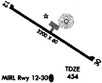
Runways
Runway Summary
| Runways: | 12/30 |
| Longest Runway: | 12/30 is 3197 ft (974 m) long |
| Runways with an Instrument Approach: |
M43 Airport Runway Details
| Runway 12/30 | 3197 ft x 60 ft (974 m x 18 m) | |
| Runway Length Source: | NGS as of 06/18/2007 | |
| Surface: | Asphalt - Good condition - No special surface treatment | |
| Runway Edge Lights: | Medium Intensity | |
Runway Weight Bearing Capacity (in thousands of pounds) |
||
| Single Wheel Landing Gear: | 20.0 | |
Runway 12 |
Runway 30 |
|
Elevation: |
454.5 | 454.2 |
Latitude: |
31-35-51.6839N | 31-35-34.5850N |
Longitude: |
089-54-38.7440W | 089-54-07.6402W |
|
Runway True Alignment: |
123 | 303 |
Glide Path Angle: |
2.8 degrees | 2.8 degrees |
Traffic Pattern: |
Left | Left |
Runway Markings Type: |
Nonprecision Instrument | Nonprecision Instrument |
Runway Markings Condition: |
Fair | Fair |
Object at End: |
TREES | |
Object Height: |
44 | |
Distance from End: |
1284 | |
Object Centerline Offset: |
250 ft. left of centerline | |
Visual Glide Slope Indicators: |
2-Light PAPI On Left Side Of Runway | 2-Light PAPI On Left Side Of Runway |
Threshold Crossing Height: |
45 | 45 |
Services
Airframe Repair: |
Major |
Powerplant Repair: |
Major |
Bottled Oxygen: |
High Pressure |
Bulk Oxygen: |
None |
Fuel Available: |
100LL, Jet A+ |
Landing Fees: |
No |
Parking: |
Tiedowns available |
Maps & Diagrams
M43 Sectional
Flight Planning
at skyvector.com
at skyvector.com