Location
Latitude: |
20-47-08.2000N (20.785611) |
Longitude: |
156-57-05.1050W (-156.951418) |
Elevation: |
1308.1 feet MSL (399 m MSL) |
Magnetic Variation: |
9.5 E (as of April 2024 from WMM2020 model) |
Time Zone: |
UTC -10.0 (Standard Time) UTC -10.0 (Daylight Savings Time) |
From City: |
03 N.M. SW of Lanai City, Hawaii |
Found On: |
Hawaiian Islands Chart |
FAA Region: |
AWP |
Contacts
Manager: |
Publicly owned: |
| MARVIN MONIZ KAHULUI ARPT KAHULUI, HI 96732 808-872-3830 |
HAWAII ST ARPTS DIV HONOLULU INTL ARPT HONOLULU, HI 96819 808-836-6432 |
Operations
Airport Status: |
Operational |
Facility Use: |
Public |
Type: |
Airport |
Activation Date: |
09/1946 |
Control tower: |
No |
Attendance (Months/Days/Hours): |
Months/Days/Hours ALL/ALL/0600-1800 |
Boundary ARTCC: |
ZHN (Honolulu Control Facility) |
Responsible ARTCC: |
ZHN (Honolulu Control Facility) |
Lighting Schedule: |
SEE RMK |
Segmented Circle Indicator: |
No |
Traffic Pattern Altitude (MSL): |
2308 feet (703 m) |
NOTAMs Facility: |
LNY |
NOTAM-D Service: |
Yes |
International Airport of Entry: |
No |
Customs Landing Rights: |
No |
Military Landing Rights: |
Yes |
Civil/Military Joint Use: |
No |
Aircraft Rescue and Firefighting: |
Class I ARFF Index: A Air Carrier Service: Scheduled Certification Date: 05/1973 |
Based Aircraft
Annual Operations (as of 02/24/2022)
| Total Operations: | 6326 | |
| Commercial: | 1588 | 25.1% |
| Air Taxi: | 4118 | 65.1% |
| GA Local: | 400 | 6.3% |
| GA Itinerant: | 150 | 2.4% |
| Military Aircraft: | 70 | 1.1% |
Communications
| CTAF: | 122.900 |
| AWOS-3P: | 118.375 (808-565-6586) |
- APCH/DEP SVC PRVDD BY HONOLULU CONTROL FACILITY (ZHN) ON FREQ 119.3 & 307.1 (MOUNT HALEAKALA RCAG).
Fixed Based Operators (FBOs) & Fuel
(Click on a business for detail)
Please help us keep this information up to date. This is a FREE SERVICE just like everything else on Airport Guide! If you see that a business needs to be added, modified, or deleted please fill out our Update Form.
To add, modify, or delete a business click here.
Please help us keep this information up to date. This is a FREE SERVICE just like everything else on Airport Guide! If you see that a business needs to be added, modified, or deleted please fill out our Update Form.
Area Code: 808 |
| Business Name | Frequency | Phone | Fuel Grade |
|---|---|---|---|
| Bradley Pacific Aviation
Update FBO info |
Arinc 130.8 | 839-2222, 877-500-0005 | Jet A |
| Signature Flight Support
Update FBO info |
Unicom: 130.8, Arinc: 130.8 | +1 808 565 7171 |
Flight Service Stations
| Primary | Alternate | |
| FSS on Field: | N | |
| FSS Name (ID): | Honolulu(HNL) | |
| Frequency: | ||
| Toll Free Phone: | 1-800-WX-BRIEF |
Instrument Procedures / Charts
FAA Terminal Procedures valid from 0901Z 03/21/24 to 0901Z 04/18/24.
There are various types of charts available for an airport. They are listed in the Page Type column. Here is a legend for those types:
APD - Airport Diagram
DP - Departure Procedure Charts
HOT - Hot Spots
IAP - Instrument Approach Procedure Charts
MIN - Minimums
STAR - Standard Terminal Arrival Charts
| Page Type | Page Name | Volume | Action Since Last Cycle |
|---|---|---|---|
| IAP | ILS OR LOC RWY 03 | PC-1 | |
| IAP | RNAV (GPS) RWY 03 | PC-1 | |
| IAP | VOR OR TACAN OR GPS-A | PC-1 | |
| IAP | VOR OR TACAN RWY 03 | PC-1 | |
| MIN | ALTERNATE MINIMUMS | PC-1 | |
| MIN | TAKEOFF MINIMUMS | PC-1 |
Terminal Procedures are only available for airports in several countries with more being added all the time. If you are looking for a specific country's charts, please send an email to support(at)airportguide.com stating the country name. This will be used to prioritize the implementation.
Navigation Aids (Navaids) near LNY
| Dist (NM) | ID | Morse Code | Name | Type | Freq | True Hdg | Mag Hdg |
|---|---|---|---|---|---|---|---|
| 1.5 | LLD | . _ . . . _ . . _ . . | Lanai | NDB | 353 | 237 | 228 |
| 1.6 | LNY | . _ . . _ . _ . _ _ | Lanai | VORTAC | 117.70 | 217 | 208 |
| 24.4 | MKK | _ _ _ . _ _ . _ | Molokai | VORTAC | 116.10 | 330 | 321 |
| 29.1 | VYI | . . . _ _ . _ _ . . | Valley Island | NDB | 327 | 78 | 69 |
| 30.6 | OGG | _ _ _ _ _ . _ _ . | Maui | VORTAC | 115.10 | 76 | 67 |
| 51.0 | CKH | _ . _ . _ . _ . . . . | Koko Head | VORTAC | 113.90 | 304 | 295 |
| 60.4 | NGF | _ . _ _ . . . _ . | Kaneohe Bay | TACAN | 114.60 | 311 | 302 |
| 63.2 | HNL | . . . . _ . . _ . . | Honolulu | VORTAC | 114.80 | 299 | 290 |
| 63.5 | HNL | . . . . _ . . _ . . | Honolulu | VOT | 111.00 | 300 | 291 |
| 69.4 | HN | . . . . _ . | Ewabe | NDB | 242 | 297 | 288 |
| 71.5 | UPP | . . _ . _ _ . . _ _ . | Upolu Point | VORTAC | 112.30 | 119 | 110 |
| 73.4 | HHI | . . . . . . . . . . | Wheeler | NDB | 373 | 304 | 295 |
| 81.9 | KOA | _ . _ _ _ _ . _ | Kona | VORTAC | 112.10 | 141 | 132 |
| 86.2 | MUE | _ _ . . _ . | Kamuela | VOR-DME | 113.30 | 123 | 114 |
| 98.0 | BSF | _ . . . . . . . . _ . | Bradshaw | NDB | 339 | 128 | 119 |
Nearby Airports with Fuel
| Dist (NM) | Name (Airport IDs) | True Hdg | Mag Hdg | Fuel Grade |
|---|---|---|---|---|
| 30.0 | Kahului Airport (OGG PHOG OGG) |
76 | 67 | 100, Jet A |
| 62.9 | Daniel K Inouye International Airport (HNL PHNL HNL) |
300 | 291 | 100, Jet A, Jet A-1+ |
| 80.9 | Ellison Onizuka Kona International At Keahole Airport (KOA PHKO KOA) |
140 | 131 | 100, Jet A |
| 84.4 | Kawaihapai Airfield Airport (HDH PHDH HDH) |
304 | 295 | 100, Jet A |
Notices to Airmen (NOTAMS)
Remarks
| A110*G | THIS AIRPORT HAS BEEN SURVEYED BY THE NATIONAL GEODETIC SURVEY. |
| A110-1 | SEE AREA NOTICES, TFC ADVYS AT NON-TWR ARPTS. |
| A110-10 | FIXED WING TSNT PRKG NE SIDE OF RAMP IS ASPH. |
| A110-11 | FOR CD IF UNA TO CTC ON FSS FREQ, CTC HONOLULU CONTROL FACILITY AT 808-840-6262. |
| A110-3 | 24 HRS PPR FOR DIVISION 1.1,1.2,1.3 EXPLOSIVES AND 4 HRS PPR FOR HAZARDOUS MATERIAL IN/OUT OF ARPT CTC 808-565-7941/7943. |
| A110-5 | DUE TO RAMP LIMITATIONS ALL ACFT PARKING LIMITED TO ONE HR EXCP VIA PPR CALL 808-565-7942; FAX 808-565-7940 OR 808-872-3880. |
| A110-8 | JET PRKG SW SIDE OF RAMP IS CONC. |
| A110-9 | POSSIBLE SEVERE UPDRAFTS/DOWNDRAFTS FROM 2 MILE FINAL APPROACH TO RUNWAY 3 THRESHHOLD. |
| A14 | ARPT OPNS/MAINT MAN/AOM/MR. ALAN FERNANDEZ PHONE 565-7942, CELL PHONE 281-9899. |
| A26 | ARPT CLOSED TO AIR CARRIER OPS WITH 10 OR MORE PASSENGER SEATS 1930-0600 EXCEPT PPR, CALL 808-565-7942. |
| A43-21 | PAPI UNUSBL BYD 2 NM DUE TO TRRN. |
| A70-FUEL-A | JET A FUEL 5000 GAL. POC: MIKE HANOC 808-286-7075 |
| A81-APT | ACTVT PAPI RWY 3 & 21; MIRL RWY 03/21 - CTAF. |
| A81-BCN | DUSK-DAWN. |
| E147 |
Runways
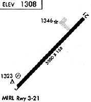
Runway Summary
| Runways: | 03/21 |
| Longest Runway: | 03/21 is 5001 ft (1524 m) long |
| Runways with an Instrument Approach: | 03 |
LNY Airport Runway Details
| Runway 03/21 | 5001 ft x 150 ft (1524 m x 46 m) | |
| Runway Length Source: | NGS as of 03/16/1994 | |
| Surface: | Asphalt - Good condition - Saw-cut or plastic grooved | |
| Runway Pavement Class: | 12 /F/A/W/T | |
| Runway Edge Lights: | Medium Intensity | |
Runway Weight Bearing Capacity (in thousands of pounds) |
||
| Single Wheel Landing Gear: | 75.0 | |
| Dual Wheel Landing Gear: | 110.0 | |
| Dual Tandem Wheel Landing Gear: | 170.0 | |
Runway 03 |
Runway 21 |
|
Elevation: |
1306.6 | 1308.1 |
Latitude: |
20-46-50.3880N | 20-47-26.0110N |
Longitude: |
156-57-23.4210W | 156-56-46.7870W |
|
Runway True Alignment: |
044 | 224 |
ILS Type: |
ILS/DME | |
Glide Path Angle: |
3.0 degrees | 3.8 degrees |
Traffic Pattern: |
Left | |
Runway Markings Type: |
Precision Instrument | Nonprecision Instrument |
Runway Markings Condition: |
Good | Good |
Object at End: |
ANT | |
Object Height: |
20 | |
Distance from End: |
1000 | |
Object Centerline Offset: |
250 ft. right of centerline | |
Visual Glide Slope Indicators: |
4-Light PAPI On Right Side Of Runway | 4-Light PAPI On Left Side Of Runway |
REIL: |
No | |
Touchdown Lights: |
No | No |
Centerline Lights: |
No | No |
Threshold Crossing Height: |
49 | 45 |
Declared Distances |
||
Take Off Run Avbl. (TORA): |
5000 | 5000 |
Take Off Distance Avbl. (TODA): |
5000 | 5000 |
Actual Stop Dist. Avbl. (ASDA): |
5000 | 5000 |
Landing Dist. Avbl. (LDA): |
5000 | 5000 |
Services
Airframe Repair: |
Major |
Powerplant Repair: |
Major |
Fuel Available: |
100, Jet A |
Landing Fees: |
No |
Parking: |
Tiedowns available |
Maps & Diagrams
LNY Sectional
Flight Planning
at skyvector.com
at skyvector.com