Location
Latitude: |
36-16-48.0000N (36.28) |
Longitude: |
080-47-09.8000W (-80.786056) |
Elevation: |
1067.2 feet MSL (325 m MSL) |
Magnetic Variation: |
8.2 W (as of April 2024 from WMM2020 model) |
Time Zone: |
UTC -5.0 (Standard Time) UTC -4.0 (Daylight Savings Time) |
From City: |
03 N.M. NE of Elkin, North Carolina |
Found On: |
Cincinnati Chart |
FAA Region: |
ASO |
Contacts
Manager: |
Publicly owned: |
| STEVE (SANDY) SHORE 1598 CC CAMP ROAD ELKIN, NC 28621 336-366-3433 |
TOWN OF ELKIN TOWN HALL - PO BOX 857 ELKIN, NC 28621 (336) 794-6464 |
Operations
Airport Status: |
Operational |
Facility Use: |
Public |
Type: |
Airport |
Control tower: |
No |
Attendance (Months/Days/Hours): |
Months/Days/Hours ALL/ALL/0900-1700 |
Boundary ARTCC: |
ZTL (Atlanta) |
Responsible ARTCC: |
ZTL (Atlanta) |
Lighting Schedule: |
SEE RMK |
Segmented Circle Indicator: |
Yes |
Traffic Pattern Altitude (MSL): |
2067 feet (630 m) |
NOTAMs Facility: |
RDU |
NOTAM-D Service: |
Yes |
International Airport of Entry: |
No |
Customs Landing Rights: |
No |
Military Landing Rights: |
Yes |
Civil/Military Joint Use: |
No |
Based Aircraft
| Single Engine: | 18 |
| Multi Engine: | 1 |
| GA Helicopters: | 1 |
Annual Operations (as of 07/05/2021)
| Total Operations: | 13350 | |
| GA Local: | 7000 | 52.4% |
| GA Itinerant: | 6000 | 44.9% |
| Military Aircraft: | 350 | 2.6% |
Communications
| CTAF: | 123.050 |
| Unicom: | 123.050 |
- APCH/DEP SVC PRVDD BY ATLANTA ARTCC ON FREQS 125.15/263.0 (HICKORY RCAG).
Fixed Based Operators (FBOs) & Fuel
(Click on a business for detail)
Please help us keep this information up to date. This is a FREE SERVICE just like everything else on Airport Guide! If you see that a business needs to be added, modified, or deleted please fill out our Update Form.
To add, modify, or delete a business click here.
Please help us keep this information up to date. This is a FREE SERVICE just like everything else on Airport Guide! If you see that a business needs to be added, modified, or deleted please fill out our Update Form.
Area Code: 336 |
| Business Name | Frequency | Phone | Fuel Grade |
|---|---|---|---|
| Miller Flying Service, Inc.
Update FBO info |
Unicom 123.05 | 366-3433 | 100LL, Jet A |
Flight Service Stations
| Primary | Alternate | |
| FSS on Field: | N | |
| FSS Name (ID): | Raleigh(RDU) | |
| Frequency: | ||
| Toll Free Phone: | 1-800-WX-BRIEF |
Instrument Procedures / Charts
FAA Terminal Procedures valid from 0901Z 03/21/24 to 0901Z 04/18/24.
There are various types of charts available for an airport. They are listed in the Page Type column. Here is a legend for those types:
APD - Airport Diagram
DP - Departure Procedure Charts
HOT - Hot Spots
IAP - Instrument Approach Procedure Charts
MIN - Minimums
STAR - Standard Terminal Arrival Charts
| Page Type | Page Name | Volume | Action Since Last Cycle |
|---|---|---|---|
| IAP | RNAV (GPS) RWY 07 | SE-2 | |
| IAP | RNAV (GPS) RWY 25 | SE-2 | |
| MIN | TAKEOFF MINIMUMS | SE-2 |
Terminal Procedures are only available for airports in several countries with more being added all the time. If you are looking for a specific country's charts, please send an email to support(at)airportguide.com stating the country name. This will be used to prioritize the implementation.
Navigation Aids (Navaids) near KZEF
| Dist (NM) | ID | Morse Code | Name | Type | Freq | True Hdg | Mag Hdg |
|---|---|---|---|---|---|---|---|
| 3.4 | ZEF | _ _ . . . . . _ . | Zephyr | NDB | 326 | 58 | 66 |
| 13.3 | AZW | . _ _ _ . . . _ _ | Mount Airy | NDB | 223 | 62 | 70 |
| 18.1 | UKF | . . _ _ . _ . . _ . | Wilki | NDB | 209 | 236 | 244 |
| 27.5 | JUH | . _ _ _ . . _ . . . . | Ashee | NDB | 410 | 289 | 297 |
| 29.0 | HLX | . . . . . _ . . _ . . _ | Hillsville | NDB | 269 | 356 | 364 |
| 32.5 | IN | . . _ . | Reeno | NDB | 317 | 112 | 120 |
| 33.1 | BZM | _ . . . _ _ . . _ _ | Barretts Mountain | VOR-DME | 113.75 | 221 | 229 |
| 35.8 | RU | . _ . . . _ | Rovdy | NDB | 275 | 156 | 164 |
| 38.9 | HK | . . . . _ . _ | Tawba | NDB | 332 | 220 | 228 |
| 41.7 | GSO | _ _ . . . . _ _ _ | Greensboro | VORTAC | 116.20 | 109 | 117 |
| 43.6 | HKY | . . . . _ . _ _ . _ _ | Hickory Regional | VOT | 110.00 | 222 | 230 |
| 44.3 | MKJ | _ _ _ . _ . _ _ _ | Suzze | NDB | 335 | 330 | 338 |
| 45.9 | UV | . . _ . . . _ | Bales | NDB | 396 | 65 | 73 |
| 46.9 | IZN | . . _ _ . . _ . | Lincolnton | NDB | 432 | 198 | 206 |
| 47.0 | OQA | _ _ _ _ _ . _ . _ | Rockingham County | FAN MARKER | 78 | 87 | |
| 48.6 | PSK | . _ _ . . . . _ . _ | Pulaski | VORTAC | 116.80 | 4 | 12 |
| 49.8 | SIF | . . . . . . . _ . | Slammer | NDB | 423 | 82 | 91 |
| 50.0 | MRN | _ _ . _ . _ . | Lenoir | FAN MARKER | 234 | 242 | |
| 53.5 | BAR | _ . . . . _ . _ . | Hemlock | NDB | 320 | 262 | 270 |
| 54.9 | FIQ | . . _ . . . _ _ . _ | Fiddlers | NDB | 391 | 231 | 239 |
Nearby Airports with Fuel
Notices to Airmen (NOTAMS)
Remarks
| A110-2 | RWY 07 SAFETY AREA HAS 80+ FT DROP-OFF AT END AND 90 FT BOTH SIDES OF CNTRLN. |
| A110-3 | DEER ON AND INVOF ARPT. |
| A110-4 | RWY 25 HAS AN UPHILL GRADE. |
| A110-5 | FOR SERVICE AFTER HOURS CALL (336)-874-7171, (336)-874-2931, (336)-366-7994, OR (336)-926-6243. |
| A110-6 | FOR CD CTC ATLANTA ARTCC AT 770-210-7692. |
| A110-7 | RWY 25 HAS UP TO 100+ FT DROP-OFF FIRST 600 FT AND 90 FT BOTH SIDES OF CNTRLN. |
| A110-8 | RWY 25 HAS UNMARKED POWER LINES 800 FT FM THR BOTH SIDES OF CNTRLN. |
| A43-07 | UNUSBL 7 DEG LEFT AND RIGHT OF RCL. |
| A43-25 | UNUSBL 9 DEG RIGHT OF RCL. |
| A70-FUEL-10 | 0LL 24 HR SELF SERVICE W/ CREDIT CARD. |
| A81-APT | ACTVT REIL RWY 07 & 25; PAPI RWY 07 & 25; MIRL RWY 07/25 - CTAF. |
| E147 | MIN ALT 500 FT AGL BASE TURN TO FINAL RWY 25. |
Runways
Runway Summary
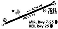
| Runways: | 07/25 |
| Longest Runway: | 07/25 is 4001 ft (1220 m) long |
| Runways with an Instrument Approach: |
KZEF Airport Runway Details
| Runway 07/25 | 4001 ft x 75 ft (1220 m x 23 m) | |
| Runway Length Source: | 3RD PARTY SURVEY as of 01/19/2010 | |
| Surface: | Asphalt - Good condition - No special surface treatment | |
| Runway Edge Lights: | Medium Intensity | |
Runway Weight Bearing Capacity (in thousands of pounds) |
||
| Single Wheel Landing Gear: | 25.0 | |
Runway 07 |
Runway 25 |
|
Elevation: |
1067.0 | 1036.8 |
Latitude: |
36-16-40.1539N | 36-16-55.9313N |
Longitude: |
080-47-32.2417W | 080-46-47.4343W |
|
Runway True Alignment: |
067 | 247 |
Glide Path Angle: |
3.0 degrees | 3.0 degrees |
Traffic Pattern: |
Left | Left |
Runway Markings Type: |
Nonprecision Instrument | Nonprecision Instrument |
Runway Markings Condition: |
Good | Good |
Object at End: |
TREES | TREES |
Object Height: |
29 | 45 |
Distance from End: |
398 | 329 |
Object Centerline Offset: |
141 ft. right of centerline | 208 ft. right of centerline |
Visual Glide Slope Indicators: |
2-Light PAPI On Left Side Of Runway | 2-Light PAPI On Left Side Of Runway |
REIL: |
Yes | Yes |
Threshold Crossing Height: |
48 | 42 |
Services
Airframe Repair: |
Major |
Powerplant Repair: |
Major |
Bottled Oxygen: |
None |
Bulk Oxygen: |
None |
Fuel Available: |
100LL, Jet A-1+ |
Landing Fees: |
No |
Parking: |
Hangars and tiedowns available |
Maps & Diagrams
KZEF Sectional
Flight Planning
at skyvector.com
at skyvector.com