
Location
Latitude: |
02-44-44.0878N (2.74558) |
Longitude: |
101-42-35.9967E (101.709999) |
Elevation: |
69 feet MSL (21 m MSL) |
Magnetic Variation: |
0.2 W (as of April 2024 from WMM2020 model) |
Time Zone: |
UTC +8.0 (Standard Time) UTC +8.0 (Daylight Savings Time) |
Contacts
Manager: |
: |
Operations
Airport Status: |
Operational |
Facility Use: |
Public |
Type: |
Airport |
Traffic Pattern Altitude (MSL): |
1069 feet (326 m) |
Based Aircraft
Annual Operations (as of )
Communications
| LUMPUR TWR RWY 15/33: | 119.8 |
| LUMPUR TWR 14L/32R: | 118.8 |
| LUMPUR TWR 14R/32L: | 118.5 |
| LUMPUR CLNC DEL: | 126 |
| LUMPUR GND: | 122.275 |
| LUMPUR GND: | 121.65 |
| LUMPUR APP: | 119.45 |
| LUMPUR DEPARTURE: | 135.25 |
| LUMPUR ATIS FOR DEPARTURE: | 126.45 |
| LUMPUR ATIS FOR ARRIVALS: | 128.05 |
Fixed Based Operators (FBOs) & Fuel
(Click on a business for detail)
Please help us keep this information up to date. This is a FREE SERVICE just like everything else on Airport Guide! If you see that a business needs to be added, modified, or deleted please fill out our Update Form.
To add, modify, or delete a business click here.
Please help us keep this information up to date. This is a FREE SERVICE just like everything else on Airport Guide! If you see that a business needs to be added, modified, or deleted please fill out our Update Form.
| Business Name | Frequency | Phone | Fuel Grade |
|---|
Flight Service Stations
| Primary | Alternate | |
| FSS on Field: | ||
| FSS Name (ID): | ||
| Frequency: | ||
| Toll Free Phone: |
Instrument Procedures / Charts
Terminal Procedures are only available for airports in several countries with more being added all the time. If you are looking for a specific country's charts, please send an email to support(at)airportguide.com stating the country name. This will be used to prioritize the implementation.
Navigation Aids (Navaids) near KUL
| Dist (NM) | ID | Morse Code | Name | Type | Freq | True Hdg | Mag Hdg |
|---|---|---|---|---|---|---|---|
| 2.1 | VKL | Kuala Lumpur | VOR-DME | 116.10 | 127 | 127 | |
| 16.8 | KL | Kayell | NDB | 255 | 341 | 341 | |
| 22.1 | SM | Kuala Lumpur | NDB | 355 | 338 | 338 | |
| 29.8 | NM | Kuala Lumpur | NDB | 338 | 336 | 336 | |
| 36.4 | CE | Caledonian | NDB | 205 | 334 | 334 | |
| 37.9 | VBA | Batu Arang | VOR-DME | 114.70 | 336 | 336 | |
| 43.4 | AM | Malacca | NDB | 298 | 131 | 131 | |
| 43.7 | VMK | Malacca | VOR-DME | 117.40 | 132 | 132 | |
| 44.5 | MC | Malacca | NDB | 362 | 136 | 136 | |
| 67.8 | DM | Dumai | NDB | 343 | 192 | 192 | |
| 85.7 | TA | Telok Intan | NDB | 315 | 331 | 331 | |
| 86.4 | SP | Sei pPkning | NDB | 305 | 162 | 162 | |
| 91.0 | BP | Batu Pahat | NDB | 276 | 126 | 126 |
Nearby Airports with Fuel
| Dist (NM) | Name (Airport IDs) | True Hdg | Mag Hdg | Fuel Grade |
|---|
Notices to Airmen (NOTAMS)
Remarks
No remarks for this landing facility
Runways
Runway Summary
| Runways: | 14L/32R 14R/32L 15/33 |
| Longest Runway: | 14L/32R is 13530 ft (4124 m) long |
| Runways with an Instrument Approach: |
KUL Airport Runway Details
| Runway 14L/32R | 13530 ft x 197 ft (4124 m x 60 m) | |
| Runway Edge Lights: | Yes Intensity | |
Runway 14L |
Runway 32R |
|
Elevation: |
55 | 70 |
Latitude: |
2.778280019760 | 2.747390031814 |
Longitude: |
101.70200347900 | 101.72200012207 |
|
Runway True Alignment: |
145.9 | 325.9 |
Glide Path Angle: |
0.0 degrees | 0.0 degrees |
REIL: |
Yes | Yes |
Threshold Elevation: |
55 | 70 |
Displaced Threshold: |
344 |
| Runway 14R/32L | 13288 ft x 197 ft (4050 m x 60 m) | |
| Runway Edge Lights: | Yes Intensity | |
Runway 14R |
Runway 32L |
|
Elevation: |
54 | 48 |
Latitude: |
2.743510007858 | 2.713129997253 |
Longitude: |
101.69799804687 | 101.71800231933 |
|
Runway True Alignment: |
146 | 326 |
Glide Path Angle: |
0.0 degrees | 0.0 degrees |
REIL: |
Yes | Yes |
Threshold Elevation: |
54 | 48 |
Displaced Threshold: |
184 |
| Runway 15/33 | 12993 ft x 197 ft (3960 m x 60 m) | |
| Runway Edge Lights: | Yes Intensity | |
Runway 15 |
Runway 33 |
|
Elevation: |
27 | 27 |
Latitude: |
2.73817 | 2.7085 |
Longitude: |
101.6775 | 101.69733 |
|
Runway True Alignment: |
146 | 326 |
Glide Path Angle: |
0.0 degrees | 0.0 degrees |
REIL: |
Yes | Yes |
Threshold Elevation: |
27 | 27 |
Services
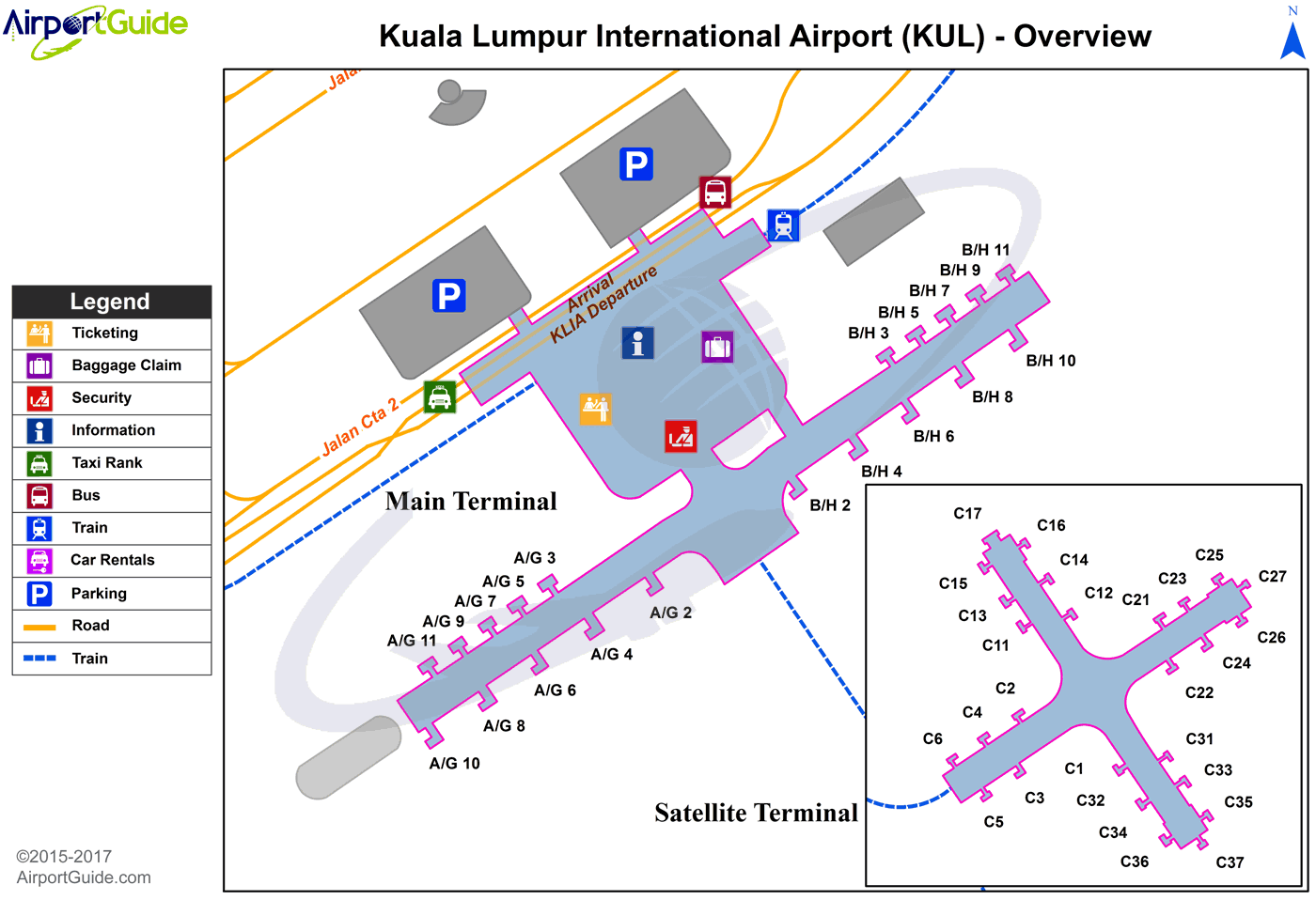
Maps & Diagrams
KUL Sectional
Flight Planning
at skyvector.com
at skyvector.com
