Location
Latitude: |
38-03-29.3000N (38.058139) |
Longitude: |
083-58-46.5000W (-83.979583) |
Elevation: |
1019.3 feet MSL (311 m MSL) |
Magnetic Variation: |
6.3 W (as of April 2024 from WMM2020 model) |
Time Zone: |
UTC -5.0 (Standard Time) UTC -4.0 (Daylight Savings Time) |
From City: |
02 N.M. W of Mount Sterling, Kentucky |
Found On: |
Cincinnati Chart |
FAA Region: |
ASO |
Contacts
Manager: |
Publicly owned: |
| ZACHARY HILL 709 AIRPORT ROAD MT. STERLING, KY 40353 859-498-1000 |
MT STERLING-MONTGOMERY COUNTY 709 AIRPORT ROAD MT. STERLING, KY 40353 859-498-1000 |
Operations
Airport Status: |
Operational |
Facility Use: |
Public |
Type: |
Airport |
Activation Date: |
11/1964 |
Control tower: |
No |
Attendance (Months/Days/Hours): |
Months/Days/Hours ALL/ALL/0800-1800 |
Boundary ARTCC: |
ZID (Indianapolis) |
Responsible ARTCC: |
ZID (Indianapolis) |
Lighting Schedule: |
SEE RMK |
Segmented Circle Indicator: |
Yes |
Traffic Pattern Altitude (MSL): |
2019 feet (615 m) |
NOTAMs Facility: |
LOU |
NOTAM-D Service: |
Yes |
International Airport of Entry: |
No |
Customs Landing Rights: |
No |
Military Landing Rights: |
Yes |
Civil/Military Joint Use: |
No |
Based Aircraft
| Single Engine: | 59 |
| Multi Engine: | 13 |
| Jet Engine: | 2 |
| GA Helicopters: | 5 |
Annual Operations (as of 06/21/2022)
| Total Operations: | 39918 | |
| Air Taxi: | 4658 | 11.7% |
| GA Local: | 18400 | 46.1% |
| GA Itinerant: | 15985 | 40.0% |
| Military Aircraft: | 875 | 2.2% |
Communications
| CTAF: | 122.800 |
| Unicom: | 122.800 |
| Approach: | LEXINGTON 120.15 120.15 |
| Departure: | LEXINGTON 120.15 120.15 |
| AWOS-3: | 120.675 (859-498-7001) |
Fixed Based Operators (FBOs) & Fuel
(Click on a business for detail)
Please help us keep this information up to date. This is a FREE SERVICE just like everything else on Airport Guide! If you see that a business needs to be added, modified, or deleted please fill out our Update Form.
To add, modify, or delete a business click here.
Please help us keep this information up to date. This is a FREE SERVICE just like everything else on Airport Guide! If you see that a business needs to be added, modified, or deleted please fill out our Update Form.
Area Code: 859 |
| Business Name | Frequency | Phone | Fuel Grade |
|---|---|---|---|
| Avionics Authority, Inc.
Update FBO info |
Unicom 122.8 | 498-9108 | 100LL, Jet A |
| Kentucky Airmotive, Inc.
Update FBO info |
Unicom 122.8 | 498-1000 | 100LL, Jet A |
Flight Service Stations
| Primary | Alternate | |
| FSS on Field: | N | |
| FSS Name (ID): | Louisville(LOU) | |
| Frequency: | ||
| Toll Free Phone: | 1-800-WX-BRIEF |
Instrument Procedures / Charts
FAA Terminal Procedures valid from 0901Z 03/21/24 to 0901Z 04/18/24.
There are various types of charts available for an airport. They are listed in the Page Type column. Here is a legend for those types:
APD - Airport Diagram
DP - Departure Procedure Charts
HOT - Hot Spots
IAP - Instrument Approach Procedure Charts
MIN - Minimums
STAR - Standard Terminal Arrival Charts
| Page Type | Page Name | Volume | Action Since Last Cycle |
|---|---|---|---|
| IAP | RNAV (GPS) RWY 03 | SE-1 | |
| IAP | RNAV (GPS) RWY 21 | SE-1 | |
| MIN | TAKEOFF MINIMUMS | SE-1 |
Terminal Procedures are only available for airports in several countries with more being added all the time. If you are looking for a specific country's charts, please send an email to support(at)airportguide.com stating the country name. This will be used to prioritize the implementation.
Navigation Aids (Navaids) near KIOB
| Dist (NM) | ID | Morse Code | Name | Type | Freq | True Hdg | Mag Hdg |
|---|---|---|---|---|---|---|---|
| 0.1 | IOB | . . _ _ _ _ . . . | Mount Sterling | NDB | 210 | 317 | 323 |
| 18.2 | XYC | _ . . _ _ . _ _ _ . _ . | Seco | NDB | 393 | 187 | 193 |
| 23.9 | HYK | . . . . _ . _ _ _ . _ | Lexington | VOR-DME | 112.60 | 256 | 262 |
| 25.2 | GN | _ _ . _ . | Bridl | NDB | 340 | 279 | 285 |
| 32.5 | LE | . _ . . . | Blayd | NDB | 242 | 262 | 268 |
| 34.7 | XW | _ . . _ . _ _ | Flmng | NDB | 400 | 26 | 32 |
| 38.7 | FLM | . . _ . . _ . . _ _ | Falmouth | VOR-DME | 117.00 | 336 | 342 |
| 44.5 | FFT | . . _ . . . _ . _ | Frankfort | VOR | 109.40 | 279 | 285 |
| 47.1 | DVK | _ . . . . . _ _ . _ | Goodall | NDB | 311 | 232 | 238 |
| 50.8 | ECB | . _ . _ . _ . . . | Newcombe | DME | 110.4 | 82 | 89 |
| 51.7 | AMT | . _ _ _ _ | West Union | NDB | 359 | 22 | 29 |
| 52.5 | AZQ | . _ _ _ . . _ _ . _ | Hazard | DME | 111.2 | 139 | 146 |
| 58.8 | YRK | _ . _ _ . _ . _ . _ | York | VORTAC | 112.80 | 52 | 59 |
| 60.2 | PZO | . _ _ . _ _ . . _ _ _ | Peebles | NDB | 329 | 30 | 37 |
| 61.8 | LOZ | . _ . . _ _ _ _ _ . . | London | VOR-DME | 116.55 | 185 | 191 |
| 62.1 | PWF | . _ _ . . _ _ . . _ . | Sportys | NDB | 245 | 349 | 355 |
| 64.8 | IKY | . . _ . _ _ . _ _ | Springfield | NDB | 429 | 247 | 253 |
| 66.3 | LUK | . _ . . . . _ _ . _ | Cincinnati Muni/Lunken | VOT | 108.40 | 341 | 347 |
| 66.8 | CVG | _ . _ . . . . _ _ _ . | Cincinnati | VORTAC | 117.30 | 329 | 335 |
| 68.2 | LUK | . _ . . . . _ _ . _ | Cincinnati | NDB | 335 | 345 | 351 |
Nearby Airports with Fuel
Notices to Airmen (NOTAMS)
Remarks
| A110-1 | HELI 1.1 NM & 1.9 NM NE. |
| A110-3 | GCO AVBL ON FREQ 121.72 THRU LEX CD. |
| A110-4 | FOR CD IF UNA VIA GCO CTC LEXINGTON APCH AT 859-514-7890. |
| A16 | 859-585-0824 |
| A17 | SVC AFT HR - AMGR OR 859-585-9936. |
| A70-FUEL-10 | 0LL FUEL AVBL 24/7 WITH CC. |
| A81-APT | ACTVT REIL RWY 03 & 21; PAPI RWY 03 & 21; MIRL RWY 03/21 - CTAF |
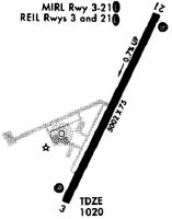
Runways
Runway Summary
| Runways: | 03/21 |
| Longest Runway: | 03/21 is 5000 ft (1524 m) long |
| Runways with an Instrument Approach: |
KIOB Airport Runway Details
| Runway 03/21 | 5000 ft x 75 ft (1524 m x 23 m) | |
| Runway Length Source: | 3RD PARTY SURVEY as of 11/29/2010 | |
| Surface: | Asphalt - Good condition - No special surface treatment | |
| Runway Pavement Class: | 9 /F/D/X/T | |
| Runway Edge Lights: | Medium Intensity | |
Runway Weight Bearing Capacity (in thousands of pounds) |
||
| Single Wheel Landing Gear: | 20.0 | |
Runway 03 |
Runway 21 |
|
Elevation: |
1019.3 | 983.7 |
Latitude: |
38-03-07.2909N | 38-03-51.2779N |
Longitude: |
083-59-00.7171W | 083-58-32.2111W |
|
Runway True Alignment: |
027 | 207 |
Glide Path Angle: |
4.0 degrees | 3.0 degrees |
Runway Markings Type: |
Nonprecision Instrument | Nonprecision Instrument |
Runway Markings Condition: |
Good | Good |
Object at End: |
TREE | TREE |
Object Height: |
78 | 49 |
Distance from End: |
1737 | 1604 |
Object Centerline Offset: |
424 ft. right of centerline | 88 ft. right of centerline |
Visual Glide Slope Indicators: |
2-Light PAPI On Left Side Of Runway | 2-Light PAPI On Left Side Of Runway |
REIL: |
Yes | Yes |
Threshold Crossing Height: |
36 | 40 |
Services
Fuel Available: |
100LL, Jet A+ |
Landing Fees: |
No |
Parking: |
Hangars and tiedowns available |
Maps & Diagrams
KIOB Sectional
Flight Planning
at skyvector.com
at skyvector.com