Location
Latitude: |
31-44-08.5920N (31.73572) |
Longitude: |
093-05-56.8910W (-93.099136) |
Elevation: |
121.0 feet MSL (37 m MSL) |
Magnetic Variation: |
0.4 E (as of April 2024 from WMM2020 model) |
Time Zone: |
UTC -6.0 (Standard Time) UTC -5.0 (Daylight Savings Time) |
From City: |
02 N.M. S of Natchitoches, Louisiana |
Found On: |
Houston Chart |
FAA Region: |
ASW |
Contacts
Manager: |
Publicly owned: |
| LARRY COOPER 450 WALLENBERG DRIVE NATCHITOCHES, LA 71457 318-352-0994 |
CITY OF NATCHITOCHES PO BOX 37 NATCHITOCHES, LA 71457 318-352-0994 |
Operations
Airport Status: |
Operational |
Facility Use: |
Public |
Type: |
Airport |
Activation Date: |
04/1940 |
Control tower: |
No |
Attendance (Months/Days/Hours): |
Months/Days/Hours ALL/ALL/DAWN-DUSK |
Boundary ARTCC: |
ZFW (Fort Worth) |
Responsible ARTCC: |
ZHU (Houston) |
Lighting Schedule: |
SEE RMK |
Segmented Circle Indicator: |
No |
Traffic Pattern Altitude (MSL): |
1121 feet (342 m) |
NOTAMs Facility: |
IER |
NOTAM-D Service: |
Yes |
International Airport of Entry: |
No |
Customs Landing Rights: |
No |
Military Landing Rights: |
Yes |
Civil/Military Joint Use: |
No |
Based Aircraft
| Single Engine: | 31 |
| Multi Engine: | 6 |
| Jet Engine: | 2 |
| GA Helicopters: | 1 |
Annual Operations (as of 04/17/2020)
| Total Operations: | 11915 | |
| Air Taxi: | 200 | 1.7% |
| GA Local: | 5850 | 49.1% |
| GA Itinerant: | 5690 | 47.8% |
| Military Aircraft: | 175 | 1.5% |
Communications
| CTAF: | 122.800 |
| Unicom: | 122.800 |
| Approach: | POLK 125.4 125.4 |
| Departure: | POLK 125.4 125.4 |
| AWOS-3: | 119.025 (318-352-1575) |
Fixed Based Operators (FBOs) & Fuel
(Click on a business for detail)
Please help us keep this information up to date. This is a FREE SERVICE just like everything else on Airport Guide! If you see that a business needs to be added, modified, or deleted please fill out our Update Form.
To add, modify, or delete a business click here.
Please help us keep this information up to date. This is a FREE SERVICE just like everything else on Airport Guide! If you see that a business needs to be added, modified, or deleted please fill out our Update Form.
Area Code: 318 |
| Business Name | Frequency | Phone | Fuel Grade |
|---|---|---|---|
| Alpha Aviation, Inc.
Update FBO info |
Unicom 122.8 | 352-0994 | 100LL, Jet A |
Flight Service Stations
| Primary | Alternate | |
| FSS on Field: | N | |
| FSS Name (ID): | De Ridder(DRI) | |
| Frequency: | ||
| Toll Free Phone: | 1-800-WX-BRIEF |
Instrument Procedures / Charts
FAA Terminal Procedures valid from 0901Z 03/21/24 to 0901Z 04/18/24.
There are various types of charts available for an airport. They are listed in the Page Type column. Here is a legend for those types:
APD - Airport Diagram
DP - Departure Procedure Charts
HOT - Hot Spots
IAP - Instrument Approach Procedure Charts
MIN - Minimums
STAR - Standard Terminal Arrival Charts
| Page Type | Page Name | Volume | Action Since Last Cycle |
|---|---|---|---|
| IAP | LOC RWY 35 | SC-4 | |
| IAP | NDB RWY 35 | SC-4 | |
| IAP | RNAV (GPS) RWY 17 | SC-4 | |
| IAP | RNAV (GPS) RWY 35 | SC-4 | |
| MIN | ALTERNATE MINIMUMS | SC-4 | |
| MIN | TAKEOFF MINIMUMS | SC-4 |
Terminal Procedures are only available for airports in several countries with more being added all the time. If you are looking for a specific country's charts, please send an email to support(at)airportguide.com stating the country name. This will be used to prioritize the implementation.
Navigation Aids (Navaids) near KIER
| Dist (NM) | ID | Morse Code | Name | Type | Freq | True Hdg | Mag Hdg |
|---|---|---|---|---|---|---|---|
| 4.8 | OOC | _ _ _ _ _ _ _ . _ . | Natchitoches | NDB | 407 | 166 | 166 |
| 24.7 | MMY | _ _ _ _ _ . _ _ | Many | NDB | 272 | 246 | 245 |
| 25.8 | SWB | . . . . _ _ _ . . . | Sawmill | VOR-DME | 113.75 | 56 | 56 |
| 34.0 | JBL | . _ _ _ _ . . . . _ . . | Hodge | NDB | 256 | 34 | 34 |
| 38.0 | FXU | . . _ . _ . . _ . . _ | Polk | VOR | 108.40 | 189 | 189 |
| 38.0 | POE1 | . _ _ . _ _ _ . | North | FAN MARKER | 189 | 189 | |
| 39.2 | MSD | _ _ . . . _ . . | Mansfield | NDB | 414 | 300 | 299 |
| 40.0 | VED | . . . _ . _ . . | Leesville | NDB | 247 | 198 | 198 |
| 42.0 | AEX | . _ . _ . . _ | Alexandria | VORTAC | 116.10 | 133 | 133 |
| 42.7 | GUV | _ _ . . . _ . . . _ | Gator | NDB | 359 | 185 | 185 |
| 45.6 | POE | . _ _ . _ _ _ . | South | FAN MARKER | 184 | 184 | |
| 47.2 | EMG | . _ _ _ _ . | Elm Grove | VORTAC | 111.20 | 327 | 326 |
| 48.0 | TUF | _ . . _ . . _ . | Stuckey | NDB | 350 | 32 | 32 |
| 54.1 | CZJ | _ . _ . _ _ . . . _ _ _ | Amason | NDB | 341 | 276 | 275 |
| 54.4 | BAD | _ . . . . _ _ . . | Barksdale | TACAN | 115.80 | 328 | 327 |
| 56.8 | SHV | . . . . . . . . . . _ | Shreveport | VOT | 108.20 | 318 | 317 |
| 58.2 | DTN | _ . . _ _ . | Downtown | VOR | 108.60 | 326 | 325 |
| 58.4 | ROQ | . _ . _ _ _ _ _ . _ | Ruston | NDB | 368 | 26 | 26 |
| 60.2 | DXB | _ . . _ . . _ _ . . . | De Ridder | NDB | 385 | 191 | 191 |
| 65.1 | MKV | _ _ _ . _ . . . _ | Marksville | NDB | 347 | 125 | 125 |
Nearby Airports with Fuel
Notices to Airmen (NOTAMS)
Remarks
| A110*G | THIS AIRPORT HAS BEEN SURVEYED BY THE NATIONAL GEODETIC SURVEY. |
| A110-1 | GCO AVBL ON FREQ 135.075 THRU FORT POLK APCH - 4 CLICKS; AND FSS - 6 CLICKS. |
| A110-2 | FOR CD IF UNA VIA GCO CTC POLK APCH AT 337-531-2352. |
| A17 | FOR ARPT ATTENDANT AFT HRS CALL 318-471-2106. |
| A70-FUEL-10 | 0LL FUEL AVBL 24/7 WITH CC. |
| A81-APT | ODALS RWY 35; REIL RWY 07 AND RWY 17 PRESET LOW INTST CONSLY, TO INCR INTST ACTVT - CTAF. MIRL RWY 17/35 AND RWY 7/25 PRESET LOW INTST DUSK TO DAWN, TO INCR INTST ACTVT - CTAF |
Runways
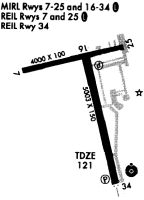
Runway Summary
| Runways: | 07/25 17/35 |
| Longest Runway: | 17/35 is 5003 ft (1525 m) long |
| Runways with an Instrument Approach: | 35 |
KIER Airport Runway Details
| Runway 07/25 | 4000 ft x 100 ft (1219 m x 30 m) | |
| Runway Length Source: | NGS as of 04/22/1989 | |
| Surface: | Asphalt - Good condition - No special surface treatment | |
| Runway Edge Lights: | Medium Intensity | |
Runway Weight Bearing Capacity (in thousands of pounds) |
||
| Single Wheel Landing Gear: | 21.0 | |
Runway 07 |
Runway 25 |
|
Elevation: |
114.8 | 117.0 |
Latitude: |
31-44-16.1860N | 31-44-25.4510N |
Longitude: |
093-06-26.5360W | 093-05-41.5050W |
|
Runway True Alignment: |
076 | 256 |
Glide Path Angle: |
3.0 degrees | 3.0 degrees |
Traffic Pattern: |
Left | Left |
Runway Markings Type: |
Nonprecision Instrument | Nonprecision Instrument |
Runway Markings Condition: |
Good | Good |
Object at End: |
TREES | TREE |
Object Height: |
98 | 82 |
Distance from End: |
2049 | 2091 |
Object Centerline Offset: |
142 ft. right of centerline | 0 ft. left and right of centerline |
Visual Glide Slope Indicators: |
2-Light PAPI On Left Side Of Runway | 2-Light PAPI On Left Side Of Runway |
REIL: |
Yes | No |
Threshold Crossing Height: |
50 | 50 |
| Runway 17/35 | 5003 ft x 150 ft (1525 m x 46 m) | |
| Runway Length Source: | NGS as of 04/22/1989 | |
| Surface: | Asphalt - Good condition - No special surface treatment | |
| Runway Edge Lights: | Medium Intensity | |
Runway Weight Bearing Capacity (in thousands of pounds) |
||
| Single Wheel Landing Gear: | 30.0 | |
Runway 17 |
Runway 35 |
|
Elevation: |
116.4 | 120.8 |
Latitude: |
31-44-22.8020N | 31-43-34.6600N |
Longitude: |
093-05-58.0440W | 093-05-44.4800W |
|
Runway True Alignment: |
166 | 346 |
ILS Type: |
LOCALIZER | |
Glide Path Angle: |
3.0 degrees | 3.0 degrees |
Traffic Pattern: |
Left | Left |
Runway Markings Type: |
Nonprecision Instrument | Nonprecision Instrument |
Runway Markings Condition: |
Fair | Fair |
Object at End: |
TREE | TREES |
Object Height: |
82 | 106 |
Distance from End: |
3600 | 3612 |
Object Centerline Offset: |
142 ft. right of centerline | 0 ft. left and right of centerline |
Visual Glide Slope Indicators: |
4-Light PAPI On Left Side Of Runway | 4-Light PAPI On Left Side Of Runway |
Approach Light System: |
Omnidirectional Approach Lighting System | |
REIL: |
Yes | No |
Threshold Crossing Height: |
45 | 43 |
Services
Airframe Repair: |
Minor |
Powerplant Repair: |
Minor |
Fuel Available: |
100LL, Jet A+ |
Landing Fees: |
No |
Parking: |
Hangars and tiedowns available |
Maps & Diagrams
KIER Sectional
Flight Planning
at skyvector.com
at skyvector.com