Location
Latitude: |
47-17-23.7670N (47.289935) |
Longitude: |
101-34-51.5200W (-101.580978) |
Elevation: |
1814.7 feet MSL (553 m MSL) |
Magnetic Variation: |
6.2 E (as of April 2024 from WMM2020 model) |
Time Zone: |
UTC -7.0 (Standard Time) UTC -6.0 (Daylight Savings Time) |
From City: |
02 N.M. E of Hazen, North Dakota |
Found On: |
Billings Chart |
FAA Region: |
AGL |
Contacts
Manager: |
Publicly owned: |
| STEVE FROVARP PO BOX 507 HAZEN, ND 58545 (701) 748-6501 |
MERCER CO REG ARPT AUTH PO BOX 507 HAZEN, ND 58545 (701) 880-0042 |
Operations
Airport Status: |
Operational |
Facility Use: |
Public |
Type: |
Airport |
Activation Date: |
05/1952 |
Control tower: |
No |
Attendance (Months/Days/Hours): |
Months/Days/Hours Unattended |
Boundary ARTCC: |
ZMP (Minneapolis) |
Responsible ARTCC: |
ZMP (Minneapolis) |
Lighting Schedule: |
SEE RMK |
Segmented Circle Indicator: |
Yes |
Traffic Pattern Altitude (MSL): |
2815 feet (858 m) |
NOTAMs Facility: |
GFK |
NOTAM-D Service: |
Yes |
International Airport of Entry: |
No |
Customs Landing Rights: |
No |
Civil/Military Joint Use: |
No |
Based Aircraft
| Single Engine: | 17 |
Annual Operations (as of 08/10/2017)
| Total Operations: | 1530 | |
| Air Taxi: | 200 | 13.1% |
| GA Local: | 800 | 52.3% |
| GA Itinerant: | 500 | 32.7% |
| Military Aircraft: | 30 | 2.0% |
Communications
| CTAF: | 122.800 |
| Unicom: | 122.800 |
| AWOS-3PT: | 118.675 (701-748-2443) |
- APCH/DEP SVC PRVDD BY MINNEAPOLIS ARTCC ON FREQS 124.25/236.825 (DICKINSON RCAG).
Fixed Based Operators (FBOs) & Fuel
(Click on a business for detail)
Please help us keep this information up to date. This is a FREE SERVICE just like everything else on Airport Guide! If you see that a business needs to be added, modified, or deleted please fill out our Update Form.
To add, modify, or delete a business click here.
Please help us keep this information up to date. This is a FREE SERVICE just like everything else on Airport Guide! If you see that a business needs to be added, modified, or deleted please fill out our Update Form.
Area Code: 701 |
| Business Name | Frequency | Phone | Fuel Grade |
|---|---|---|---|
| Mercer County Regional Airport
Update FBO info |
Unicom 122.8 | 748-5592 | 100LL, Jet A |
Flight Service Stations
| Primary | Alternate | |
| FSS on Field: | N | |
| FSS Name (ID): | Grand Forks(GFK) | |
| Frequency: | ||
| Toll Free Phone: | 1-800-WX-BRIEF |
Instrument Procedures / Charts
FAA Terminal Procedures valid from 0901Z 03/21/24 to 0901Z 04/18/24.
There are various types of charts available for an airport. They are listed in the Page Type column. Here is a legend for those types:
APD - Airport Diagram
DP - Departure Procedure Charts
HOT - Hot Spots
IAP - Instrument Approach Procedure Charts
MIN - Minimums
STAR - Standard Terminal Arrival Charts
| Page Type | Page Name | Volume | Action Since Last Cycle |
|---|---|---|---|
| IAP | RNAV (GPS) RWY 15 | NC-1 | |
| IAP | RNAV (GPS) RWY 33 | NC-1 | |
| MIN | ALTERNATE MINIMUMS | NC-1 | |
| MIN | TAKEOFF MINIMUMS | NC-1 |
Terminal Procedures are only available for airports in several countries with more being added all the time. If you are looking for a specific country's charts, please send an email to support(at)airportguide.com stating the country name. This will be used to prioritize the implementation.
Navigation Aids (Navaids) near KHZE
| Dist (NM) | ID | Morse Code | Name | Type | Freq | True Hdg | Mag Hdg |
|---|---|---|---|---|---|---|---|
| 49.1 | BIS | _ . . . . . . . . | Bismarck | VOR-DME | 115.65 | 129 | 123 |
| 52.2 | BI | _ . . . . . | Jadan | NDB | 230 | 132 | 126 |
| 55.1 | DIK | _ . . . . _ . _ | Dickinson | VORTAC | 112.90 | 242 | 235 |
| 58.7 | DI | _ . . . . | Noson | NDB | 353 | 232 | 225 |
| 59.4 | MOT | _ _ _ _ _ _ | Minot | VOR-DME | 117.10 | 11 | 5 |
| 68.1 | MIB | _ _ . . _ . . . | Deering | TACAN | 114.90 | 7 | 1 |
| 85.0 | LEM | . _ . . . _ _ | Lemmon | VOR | 111.40 | 194 | 188 |
| 92.4 | SF | . . . . . _ . | Yuson | NDB | 275 | 303 | 296 |
| 95.8 | ISN | . . . . . _ . | Williston | NDB | 275 | 303 | 296 |
Nearby Airports with Fuel
| Dist (NM) | Name (Airport IDs) | True Hdg | Mag Hdg | Fuel Grade |
|---|---|---|---|---|
| 22.9 | Washburn Municipal Airport (5C8) |
80 | 74 | 100LL |
| 42.1 | Mandan Regional/Lawler Field Airport (Y19) |
137 | 131 | 100LL, Jet A |
| 44.9 | Parshall-Hankins Airport (Y74) |
329 | 322 | 100LL |
| 46.1 | Bismarck Municipal Airport (BIS KBIS BIS) |
131 | 125 | 100LL, Jet A |
| 58.0 | Dickinson/Theodore Roosevelt Regional Airport (DIK KDIK DIK) |
240 | 233 | 100LL, Jet A |
| 59.3 | Minot International Airport (MOT KMOT MOT) |
11 | 5 | 100LL, Jet A |
| 69.2 | Stanley Municipal Airport (08D) |
331 | 324 | 100LL, Jet A+, MOGAS |
| 73.3 | Harvey Municipal Airport (5H4) |
65 | 60 | 100LL |
| 84.2 | Tioga Municipal Airport (VEX D60) |
321 | 314 | 100LL, Jet A |
| 84.8 | Kenmare Municipal Airport (7K5) |
347 | 340 | 100LL |
| 88.4 | Hettinger/Jb Lindquist Regional Airport (KHEI HEI) |
210 | 203 | 100LL, Jet A |
| 88.7 | Napoleon Municipal Airport (5B5) |
121 | 116 | 100LL |
| 88.8 | Mohall Municipal Airport (KHBC HBC) |
1 | 355 | 100LL, Jet A |
| 91.0 | Rugby Municipal Airport (KRUG RUG) |
42 | 37 | 100LL, Jet A |
Notices to Airmen (NOTAMS)
Remarks
| A110-1 | CFM SNOW REMOVAL OCT-APR; CALL 701-880-0042. |
| A110-3 | TRANSPORTATION SVC CALL 701-880-0042. |
| A110-4 | 654 FT LIGHTED TOWER 3.8 NM FM THLD RWY 15. |
| A110-5 | ACFT PAINT & UPHOLSTRY SHOP AVBL CALL 701-748-5592/6714. |
| A110-7 | BIRDS & DEER ON & INVOF ARPT. |
| A110-8 | FOR CD IF UNA TO CTC ON FSS FREQ, CTC MINNEAPOLIS ARTCC AT 651-463-5588. |
| A12 | ARPT MGR - STEVE FROVARP. |
| A13 | CHAIR OF ARPT AUTHORITY - WAYNE ENTZE. |
| A14 | ARPT MGR & CLERK OF ARPT AUTH. |
| A35-15/33 | APRON HAS 2 CONC 20000 LB SW TIEDOWN SPACES. |
| A42-15 | TWY & APRON MARKED WITH REFLECTORS. |
| A42-33 | TWY & APRON MARKED WITH REFLECTORS. |
| A70-FUEL-A | SINGLE POINT JET FUELING AVBL. |
| A70-FUEL-10 | 0LL SELF SVC FUEL AVBL H24 WITH CREDIT CARD. |
| A76 | FOR KEYS TO COURTESY VEHICLE CALL 701-880-0042 |
| A81-APT | ACTVT REIL RWY 33; PAPI RWYS 15 & 33; & MIRL RWY 15/33 - CTAF. MIRL RWY 15/33 ACTVT 1/2 HR BFR SS TO 1/2 HR AFT SR. |
Runways
Runway Summary
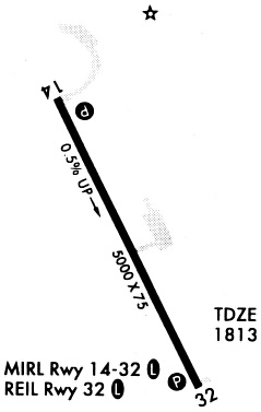
| Runways: | 15/33 |
| Longest Runway: | 15/33 is 4999 ft (1524 m) long |
| Runways with an Instrument Approach: |
KHZE Airport Runway Details
| Runway 15/33 | 4999 ft x 75 ft (1524 m x 23 m) | |
| Runway Length Source: | 3RD PARTY SURVEY as of 11/16/2021 | |
| Surface: | Asphalt - Excellent condition - No special surface treatment | |
| Runway Edge Lights: | Medium Intensity | |
Runway Weight Bearing Capacity (in thousands of pounds) |
||
| Single Wheel Landing Gear: | 17.0 | |
Runway 15 |
Runway 33 |
|
Elevation: |
1786.8 | 1814.7 |
Latitude: |
47-17-45.6973N | 47-17-01.8358N |
Longitude: |
101-35-08.1134W | 101-34-34.9305W |
|
Runway True Alignment: |
153 | 333 |
Glide Path Angle: |
3.0 degrees | 3.0 degrees |
Traffic Pattern: |
Left | Left |
Runway Markings Type: |
Nonprecision Instrument | Nonprecision Instrument |
Runway Markings Condition: |
Good | Good |
Visual Glide Slope Indicators: |
2-Light PAPI On Left Side Of Runway | 2-Light PAPI On Left Side Of Runway |
REIL: |
Yes | |
Threshold Crossing Height: |
28 | 29 |
Services
Airframe Repair: |
None |
Powerplant Repair: |
None |
Bottled Oxygen: |
None |
Bulk Oxygen: |
None |
Fuel Available: |
100LL, Jet A |
Landing Fees: |
No |
Parking: |
Hangars and tiedowns available |
Maps & Diagrams
KHZE Sectional
Flight Planning
at skyvector.com
at skyvector.com