Location
Latitude: |
44-15-02.6590N (44.250739) |
Longitude: |
090-51-19.0090W (-90.85528) |
Elevation: |
836.2 feet MSL (255 m MSL) |
Magnetic Variation: |
1.9 W (as of April 2024 from WMM2020 model) |
Time Zone: |
UTC -6.0 (Standard Time) UTC -5.0 (Daylight Savings Time) |
From City: |
03 N.M. S of Black River Falls, Wisconsin |
Found On: |
Green Bay Chart |
FAA Region: |
AGL |
Contacts
Manager: |
Publicly owned: |
| DALE KLEVGARD 101 S. SECOND ST BLACK RIVER FALLS, WI 54615 (715) 896-9434 |
BLACK RIVER FALLS & JACKSON CO 101 S. SECOND ST BLACK RIVER FALLS, WI 54615 715-284-5514 |
Operations
Airport Status: |
Operational |
Facility Use: |
Public |
Type: |
Airport |
Activation Date: |
09/1970 |
Control tower: |
No |
Attendance (Months/Days/Hours): |
Months/Days/Hours Unattended |
Boundary ARTCC: |
ZMP (Minneapolis) |
Responsible ARTCC: |
ZMP (Minneapolis) |
Lighting Schedule: |
SEE RMK |
Segmented Circle Indicator: |
No |
Traffic Pattern Altitude (MSL): |
1836 feet (560 m) |
NOTAMs Facility: |
GRB |
NOTAM-D Service: |
Yes |
International Airport of Entry: |
No |
Customs Landing Rights: |
No |
Military Landing Rights: |
Yes |
Civil/Military Joint Use: |
No |
Based Aircraft
| Single Engine: | 13 |
| Multi Engine: | 1 |
Annual Operations (as of 06/22/2022)
| Total Operations: | 1500 | |
| Air Taxi: | 100 | 6.7% |
| GA Local: | 900 | 60.0% |
| GA Itinerant: | 400 | 26.7% |
| Military Aircraft: | 100 | 6.7% |
Communications
| CTAF: | 122.900 |
| AWOS-3PT: | 119.125 (715-284-0007) |
- APCH/DEP SVC PRVDD BY MINNEAPOLIS ARTCC ON FREQS 128.6/363.0 (LA CROSSE RCAG).
Fixed Based Operators (FBOs) & Fuel
(Click on a business for detail)
Please help us keep this information up to date. This is a FREE SERVICE just like everything else on Airport Guide! If you see that a business needs to be added, modified, or deleted please fill out our Update Form.
To add, modify, or delete a business click here.
Please help us keep this information up to date. This is a FREE SERVICE just like everything else on Airport Guide! If you see that a business needs to be added, modified, or deleted please fill out our Update Form.
Area Code: 715 |
| Business Name | Frequency | Phone | Fuel Grade |
|---|
Flight Service Stations
| Primary | Alternate | |
| FSS on Field: | N | |
| FSS Name (ID): | Green Bay(GRB) | |
| Frequency: | ||
| Toll Free Phone: | 1-800-WX-BRIEF |
Instrument Procedures / Charts
FAA Terminal Procedures valid from 0901Z 03/21/24 to 0901Z 04/18/24.
There are various types of charts available for an airport. They are listed in the Page Type column. Here is a legend for those types:
APD - Airport Diagram
DP - Departure Procedure Charts
HOT - Hot Spots
IAP - Instrument Approach Procedure Charts
MIN - Minimums
STAR - Standard Terminal Arrival Charts
| Page Type | Page Name | Volume | Action Since Last Cycle |
|---|---|---|---|
| IAP | RNAV (GPS) RWY 08 | EC-3 | |
| IAP | RNAV (GPS) RWY 26 | EC-3 | |
| MIN | ALTERNATE MINIMUMS | EC-3 | |
| MIN | TAKEOFF MINIMUMS | EC-3 |
Terminal Procedures are only available for airports in several countries with more being added all the time. If you are looking for a specific country's charts, please send an email to support(at)airportguide.com stating the country name. This will be used to prioritize the implementation.
Navigation Aids (Navaids) near KBCK
| Dist (NM) | ID | Morse Code | Name | Type | Freq | True Hdg | Mag Hdg |
|---|---|---|---|---|---|---|---|
| 0.4 | BCK | _ . . . _ . _ . _ . _ | Black River Falls | NDB | 362 | 50 | 52 |
| 20.9 | CMY | _ . _ . _ _ _ . _ _ | Mccoy | NDB | 412 | 153 | 155 |
| 22.9 | LS | . _ . . . . . | Mindi | NDB | 272 | 229 | 231 |
| 23.5 | VIQ | . . . _ . . _ _ . _ | Neillsville | NDB | 368 | 38 | 40 |
| 28.4 | LSE | . _ . . . . . . | La Crosse | DME | 108.4 | 217 | 219 |
| 31.6 | VOK | . . . _ _ _ _ _ . _ | Volk | TACAN | 110.40 | 125 | 127 |
| 33.3 | ODI | _ _ _ _ . . . . | Nodine | VORTAC | 117.90 | 232 | 234 |
| 34.7 | ON | _ _ _ _ . | Bolln | NDB | 264 | 248 | 250 |
| 35.7 | DU | _ . . . . _ | Calin | NDB | 266 | 57 | 59 |
| 36.9 | MFI | _ _ . . _ . . . | Marshfield | NDB | 391 | 50 | 52 |
| 38.1 | ONA | _ _ _ _ . . _ | Winona | VOR-DME | 111.40 | 254 | 256 |
| 41.6 | EK | . _ . _ | Nepco | NDB | 326 | 88 | 90 |
| 42.3 | HBW | . . . . _ . . . . _ _ | Kickapoo | NDB | 251 | 147 | 149 |
| 44.1 | ISW | . . . . . . _ _ | Wisconsin Rapids | NDB | 215 | 80 | 82 |
| 47.1 | EAU | . . _ . . _ | Eau Claire | VORTAC | 113.65 | 325 | 327 |
| 47.2 | EA | . . _ | Maggs | NDB | 239 | 332 | 334 |
| 56.3 | MDZ | _ _ _ . . _ _ . . | Medford | NDB | 335 | 24 | 26 |
| 57.7 | PH | . _ _ . . . . . | Bayye | NDB | 351 | 63 | 65 |
| 59.4 | STE | . . . _ . | Stevens Point | VORTAC | 110.60 | 72 | 74 |
| 63.2 | DLL | _ . . . _ . . . _ . . | Dells | VORTAC | 117.00 | 131 | 133 |
Nearby Airports with Fuel
Notices to Airmen (NOTAMS)
Remarks
| A110-1 | WILDLIFE, BIRDS ON & INVOF ARPT. |
| A110-2 | FOR CD IF UNA TO CTC ON FSS FREQ, CTC MINNEAPOLIS ARTCC AT 651-463-5588. |
| A43-08 | VGSI AND RNAV GLIDEPATH NOT COINCIDENT. |
| A43-26 | VGSI AND RNAV GLIDEPATH NOT COINCIDENT. |
| A70-FUEL-10 | 0LL 24 HOUR SELF-SERVE |
| A81-APT | MIRL RWY 08/26 PRESET TO LOW SS-SR; TO INCR INTST & ACTVT REIL RWYS 08 & 26; PAPI RWYS 08 & 26 - CTAF. |
Runways
Runway Summary
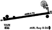
| Runways: | 08/26 |
| Longest Runway: | 08/26 is 4601 ft (1402 m) long |
| Runways with an Instrument Approach: |
KBCK Airport Runway Details
| Runway 08/26 | 4601 ft x 75 ft (1402 m x 23 m) | |
| Runway Length Source: | 3RD PARTY SURVEY as of 02/13/2010 | |
| Surface: | Asphalt - Good condition - No special surface treatment | |
| Runway Edge Lights: | Medium Intensity | |
Runway Weight Bearing Capacity (in thousands of pounds) |
||
| Single Wheel Landing Gear: | 12.0 | |
Runway 08 |
Runway 26 |
|
Elevation: |
823.2 | 836.2 |
Latitude: |
44-14-58.8937N | 44-15-06.4329N |
Longitude: |
090-51-50.1938W | 090-50-47.8654W |
|
Runway True Alignment: |
080 | 260 |
Glide Path Angle: |
3.0 degrees | 3.5 degrees |
Traffic Pattern: |
Left | Left |
Runway Markings Type: |
Nonprecision Instrument | Nonprecision Instrument |
Runway Markings Condition: |
Good | Good |
Object at End: |
TREES | TREE |
Object Height: |
24 | 51 |
Distance from End: |
340 | 1526 |
Object Centerline Offset: |
254 ft. left of centerline | 260 ft. right of centerline |
Visual Glide Slope Indicators: |
2-Light PAPI On Left Side Of Runway | 2-Light PAPI On Left Side Of Runway |
REIL: |
Yes | Yes |
Threshold Crossing Height: |
27 | 27 |
Services
Airframe Repair: |
Major |
Powerplant Repair: |
Major |
Bottled Oxygen: |
None |
Bulk Oxygen: |
None |
Fuel Available: |
100LL, Jet A+ |
Landing Fees: |
No |
Parking: |
Hangars and tiedowns available |
Maps & Diagrams
KBCK Sectional
Flight Planning
at skyvector.com
at skyvector.com