Location
Latitude: |
34-29-59.4660N (34.499852) |
Longitude: |
083-33-23.9930W (-83.556665) |
Elevation: |
1447.9 feet MSL (441 m MSL) |
Magnetic Variation: |
6.1 W (as of April 2024 from WMM2020 model) |
Time Zone: |
UTC -5.0 (Standard Time) UTC -4.0 (Daylight Savings Time) |
From City: |
02 N.M. SW of Cornelia, Georgia |
Found On: |
Atlanta Chart |
FAA Region: |
ASO |
Contacts
Manager: |
Publicly owned: |
| BILL HARDEN 1112 AIRPORT ROAD CORNELIA, GA 30531 706-839-0247 |
HABERSHAM COUNTY 555 MONROE STREET, UNIT 20 CLARKESVILLE, GA 30523 (706) 839-0200 |
Operations
Airport Status: |
Operational |
Facility Use: |
Public |
Type: |
Airport |
Activation Date: |
12/1989 |
Control tower: |
No |
Attendance (Months/Days/Hours): |
Months/Days/Hours ALL/ALL/0800-1800 |
Boundary ARTCC: |
ZTL (Atlanta) |
Responsible ARTCC: |
ZTL (Atlanta) |
Lighting Schedule: |
SEE RMK |
Segmented Circle Indicator: |
Yes |
Traffic Pattern Altitude (MSL): |
2448 feet (746 m) |
NOTAMs Facility: |
MCN |
NOTAM-D Service: |
Yes |
International Airport of Entry: |
No |
Customs Landing Rights: |
No |
Military Landing Rights: |
Yes |
Civil/Military Joint Use: |
No |
Based Aircraft
| Single Engine: | 59 |
| Multi Engine: | 4 |
| GA Helicopters: | 1 |
Annual Operations (as of 12/31/2022)
| Total Operations: | 25000 | |
| GA Local: | 15000 | 60.0% |
| GA Itinerant: | 10000 | 40.0% |
Communications
| CTAF: | 122.700 |
| Unicom: | 122.700 |
| AWOS-3: | 119.175 (706-778-3675) |
- APCH/DEP SVC PRVDD BY ATLANTA ARTCC ON FREQS 134.8/379.95 (MOUNT OGLETHORPE RCAG).
Fixed Based Operators (FBOs) & Fuel
(Click on a business for detail)
Please help us keep this information up to date. This is a FREE SERVICE just like everything else on Airport Guide! If you see that a business needs to be added, modified, or deleted please fill out our Update Form.
To add, modify, or delete a business click here.
Please help us keep this information up to date. This is a FREE SERVICE just like everything else on Airport Guide! If you see that a business needs to be added, modified, or deleted please fill out our Update Form.
Area Code: 706 |
| Business Name | Frequency | Phone | Fuel Grade |
|---|---|---|---|
| Habersham Aviation, Inc.
Update FBO info |
778-9978 | 100LL, Mogas |
Flight Service Stations
| Primary | Alternate | |
| FSS on Field: | N | |
| FSS Name (ID): | Macon(MCN) | |
| Frequency: | ||
| Toll Free Phone: | 1-800-WX-BRIEF |
Instrument Procedures / Charts
FAA Terminal Procedures valid from 0901Z 03/21/24 to 0901Z 04/18/24.
There are various types of charts available for an airport. They are listed in the Page Type column. Here is a legend for those types:
APD - Airport Diagram
DP - Departure Procedure Charts
HOT - Hot Spots
IAP - Instrument Approach Procedure Charts
MIN - Minimums
STAR - Standard Terminal Arrival Charts
| Page Type | Page Name | Volume | Action Since Last Cycle |
|---|---|---|---|
| IAP | RNAV (GPS) RWY 06 | SE-4 | |
| IAP | RNAV (GPS) RWY 24 | SE-4 | |
| MIN | ALTERNATE MINIMUMS | SE-4 | |
| MIN | TAKEOFF MINIMUMS | SE-4 |
Terminal Procedures are only available for airports in several countries with more being added all the time. If you are looking for a specific country's charts, please send an email to support(at)airportguide.com stating the country name. This will be used to prioritize the implementation.
Navigation Aids (Navaids) near KAJR
| Dist (NM) | ID | Morse Code | Name | Type | Freq | True Hdg | Mag Hdg |
|---|---|---|---|---|---|---|---|
| 0.3 | AJR | . _ . _ _ _ . _ . | Habersham | NDB | 347 | 73 | 79 |
| 17.4 | ODF | _ _ _ _ . . . . _ . | Foothills | VOR-DME | 113.40 | 47 | 53 |
| 24.8 | FKV | . . _ . _ . _ . . . _ | Flowery Branch | NDB | 365 | 224 | 230 |
| 26.3 | DDA | _ . . _ . . . _ | Commerce | NDB | 244 | 176 | 182 |
| 31.9 | HRS | . . . . . _ . . . . | Harris | VORTAC | 109.80 | 326 | 332 |
| 32.6 | TX | _ _ . . _ | Gwnet | NDB | 419 | 207 | 213 |
| 33.9 | BMW | _ . . . _ _ . _ _ | Barrow County | NDB | 404 | 182 | 188 |
| 34.7 | CEU | _ . _ . . . . _ | Clemson | NDB | 257 | 72 | 78 |
| 35.1 | AHN | . _ . . . . _ . | Athens | VOR-DME | 116.95 | 160 | 166 |
| 36.9 | BJT | _ . . . . _ _ _ _ | Bulldog | NDB | 221 | 152 | 158 |
| 38.5 | ELW | . . _ . . . _ _ | Electric City | VORTAC | 108.60 | 97 | 103 |
| 46.1 | LQK | . _ . . _ _ . _ _ . _ | Lake Keowee | NDB | 408 | 65 | 71 |
| 46.5 | JNM | . _ _ _ _ . _ _ | Monroe | NDB | 392 | 190 | 196 |
| 48.4 | DJD | _ . . . _ _ _ _ . . | Chero | NDB | 415 | 252 | 258 |
| 52.5 | PDK | . _ _ . _ . . _ . _ | Peachtree | VOR-DME | 116.60 | 224 | 230 |
| 53.4 | VOF | . . . _ _ _ _ . . _ . | Alcovy | NDB | 370 | 192 | 198 |
| 56.2 | GY | _ _ . _ . _ _ | Dyana | NDB | 338 | 77 | 84 |
| 57.1 | IIY | . . . . _ . _ _ | Washington/Wilkes County | NDB | 435 | 139 | 145 |
| 57.7 | VV | . . . _ . . . _ | Junne | NDB | 353 | 152 | 158 |
| 58.8 | DOB | _ . . _ _ _ _ . . . | Dobbins | TACAN | 113.00 | 233 | 239 |
Nearby Airports with Fuel
Notices to Airmen (NOTAMS)
Remarks
| A110-1 | RWY 24 - CALM WIND RWY. |
| A110-2 | DEER & WILDLIFE ON OR INVOF ARPT. |
| A110-3 | FOR CD CTC ATLANTA ARTCC AT 770-210-7692. |
| A110-4 | RISING TRRN NW OF RWY 06/24 STARTING AT 120 FT FROM RCL. |
| A110-5 | TWY A BTN TWY D AND TWY C CLSD TO ACFT WINGSPAN MORE THAN 80 FT. |
| A16 | ARPT PHONE NUMBER - (706) 778-0198. |
| A57-06 | APCH RATIO 26:1 TO DSPLCD THR. |
| A81-APT | MIRL RWY 06/24 PRESET ON LOW INTST DUSK-2200; TO INCR INTST - CTAF. AFT 2200 ACTVT - CTAF. |
Runways
Runway Summary
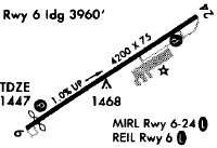
| Runways: | 06/24 |
| Longest Runway: | 06/24 is 5503 ft (1677 m) long |
| Runways with an Instrument Approach: |
KAJR Airport Runway Details
| Runway 06/24 | 5503 ft x 100 ft (1677 m x 30 m) | |
| Runway Length Source: | 3RD PARTY SURVEY as of 04/01/2019 | |
| Surface: | Asphalt - Good condition - No special surface treatment | |
| Runway Edge Lights: | Medium Intensity | |
Runway Weight Bearing Capacity (in thousands of pounds) |
||
| Single Wheel Landing Gear: | 30.0 | |
Runway 06 |
Runway 24 |
|
Elevation: |
1403.1 | 1447.4 |
Latitude: |
34-29-44.6340N | 34-30-14.2968N |
Longitude: |
083-33-51.5529W | 083-32-56.4296W |
|
Runway True Alignment: |
057 | 237 |
Glide Path Angle: |
3.2 degrees | 3.5 degrees |
Traffic Pattern: |
Left | Left |
Runway Markings Type: |
Nonprecision Instrument | Nonprecision Instrument |
Runway Markings Condition: |
Fair | Fair |
Object at End: |
TREES | TREES |
Object Height: |
58 | 23 |
Distance from End: |
664 | 453 |
Object Centerline Offset: |
307 ft. left of centerline | 163 ft. left of centerline |
Visual Glide Slope Indicators: |
2-Light PAPI On Left Side Of Runway | 2-Light PAPI On Left Side Of Runway |
Threshold Crossing Height: |
45 | 40 |
Threshold Elevation: |
1408.3 | |
Displaced Threshold: |
1392 | |
Threshold Latitude: |
34-29-52.1395N | |
Threshold Longitude: |
083-33-37.6079W | |
Declared Distances |
||
Take Off Run Avbl. (TORA): |
5503 | 5503 |
Take Off Distance Avbl. (TODA): |
5503 | 5503 |
Actual Stop Dist. Avbl. (ASDA): |
5503 | 5503 |
Landing Dist. Avbl. (LDA): |
4111 | 5503 |
Services
Airframe Repair: |
None |
Powerplant Repair: |
None |
Bottled Oxygen: |
None |
Bulk Oxygen: |
None |
Fuel Available: |
100LL, Jet A+ |
Landing Fees: |
No |
Parking: |
Tiedowns available |
Maps & Diagrams
KAJR Sectional
Flight Planning
at skyvector.com
at skyvector.com