Location
Latitude: |
40-36-23.5000N (40.606528) |
Longitude: |
095-52-00.0000W (-95.866667) |
Elevation: |
1165.0 feet MSL (355 m MSL) |
Magnetic Variation: |
2.1 E (as of April 2024 from WMM2020 model) |
Time Zone: |
UTC -6.0 (Standard Time) UTC -5.0 (Daylight Savings Time) |
From City: |
04 N.M. S of Nebraska City, Nebraska |
Found On: |
Omaha Chart |
FAA Region: |
ACE |
Contacts
Manager: |
Publicly owned: |
| KYLE GRESS 972 S. 64TH ROAD NEBRASKA CITY, NE 68410-6805 402-873-0550 |
CITY OF NEBRASKA CITY 1409 CENTRAL AVE NEBRASKA CITY, NE 68410-2223 (402) 873-5515 |
Operations
Airport Status: |
Operational |
Facility Use: |
Public |
Type: |
Airport |
Control tower: |
No |
Attendance (Months/Days/Hours): |
Months/Days/Hours ALL/MON-FRI/0800-1700 |
Boundary ARTCC: |
ZMP (Minneapolis) |
Responsible ARTCC: |
ZMP (Minneapolis) |
Lighting Schedule: |
SEE RMK |
Segmented Circle Indicator: |
Yes |
Traffic Pattern Altitude (MSL): |
2165 feet (660 m) |
NOTAMs Facility: |
AFK |
NOTAM-D Service: |
Yes |
Based Aircraft
| Single Engine: | 11 |
| Multi Engine: | 1 |
| GA Helicopters: | 1 |
Annual Operations (as of 04/18/2023)
| Total Operations: | 4430 | |
| GA Local: | 2530 | 57.1% |
| GA Itinerant: | 1590 | 35.9% |
| Military Aircraft: | 310 | 7.0% |
Communications
| CTAF: | 122.700 |
| Unicom: | 122.700 |
| Approach: | OMAHA 120.1 120.1 |
| Departure: | OMAHA 120.1 120.1 |
| AWOS-3PT: | 128.325 (402-873-7375) |
Fixed Based Operators (FBOs) & Fuel
(Click on a business for detail)
Please help us keep this information up to date. This is a FREE SERVICE just like everything else on Airport Guide! If you see that a business needs to be added, modified, or deleted please fill out our Update Form.
To add, modify, or delete a business click here.
Please help us keep this information up to date. This is a FREE SERVICE just like everything else on Airport Guide! If you see that a business needs to be added, modified, or deleted please fill out our Update Form.
Area Code: 402 |
| Business Name | Frequency | Phone | Fuel Grade |
|---|---|---|---|
| Baker Aviation
Update FBO info |
Unicom 122.7 | 873-6646 | 100LL, Jet A |
Flight Service Stations
| Primary | Alternate | |
| FSS on Field: | N | |
| FSS Name (ID): | Columbus(OLU) | |
| Frequency: | ||
| Toll Free Phone: | 1-800-WX-BRIEF |
Instrument Procedures / Charts
FAA Terminal Procedures valid from 0901Z 03/21/24 to 0901Z 04/18/24.
There are various types of charts available for an airport. They are listed in the Page Type column. Here is a legend for those types:
APD - Airport Diagram
DP - Departure Procedure Charts
HOT - Hot Spots
IAP - Instrument Approach Procedure Charts
MIN - Minimums
STAR - Standard Terminal Arrival Charts
| Page Type | Page Name | Volume | Action Since Last Cycle |
|---|---|---|---|
| IAP | NDB RWY 15 | NC-2 | |
| IAP | NDB RWY 33 | NC-2 | |
| IAP | RNAV (GPS) RWY 15 | NC-2 | |
| IAP | RNAV (GPS) RWY 33 | NC-2 | |
| MIN | ALTERNATE MINIMUMS | NC-2 | |
| MIN | TAKEOFF MINIMUMS | NC-2 |
Terminal Procedures are only available for airports in several countries with more being added all the time. If you are looking for a specific country's charts, please send an email to support(at)airportguide.com stating the country name. This will be used to prioritize the implementation.
Navigation Aids (Navaids) near KAFK
| Dist (NM) | ID | Morse Code | Name | Type | Freq | True Hdg | Mag Hdg |
|---|---|---|---|---|---|---|---|
| 0.3 | AFK | . _ . . _ . _ . _ | Nebraska City | NDB | 347 | 104 | 102 |
| 20.3 | PMV | . _ _ . _ _ . . . _ | Plattsmouth | NDB | 329 | 354 | 352 |
| 22.6 | SDA | . . . _ . . . _ | Shenandoah | NDB | 411 | 67 | 65 |
| 28.9 | PWE | . _ _ . . _ _ . | Pawnee City | DME | 112.4 | 212 | 210 |
| 30.7 | OFF | _ _ _ . . _ . . . _ . | Offutt | TACAN | 111.70 | 357 | 355 |
| 34.2 | OVR | _ _ _ . . . _ . _ . | Omaha | VORTAC | 116.30 | 9 | 7 |
| 34.3 | FNB | . . _ . _ . _ . . . | Brenner | NDB | 404 | 158 | 156 |
| 36.9 | EN | . _ . | Rikky | NDB | 426 | 3 | 1 |
| 37.0 | RDK | . _ . _ . . _ . _ | Red Oak | NDB | 230 | 48 | 46 |
| 37.0 | MLE | _ _ . _ . . . | Millard | NDB | 371 | 342 | 340 |
| 38.8 | ICL | . . _ . _ . . _ . . | Clarinda | NDB | 353 | 79 | 77 |
| 41.3 | OMA | _ _ _ _ _ . _ | Omaha | VOT | 109.00 | 358 | 356 |
| 41.6 | LN | . _ . . _ . | Potts | NDB | 385 | 281 | 279 |
| 44.1 | LNK | . _ . . _ . _ . _ | Lincoln | VORTAC | 116.10 | 295 | 293 |
| 44.5 | BIE | _ . . . . . . | Beatrice | VOR | 110.60 | 245 | 243 |
| 45.8 | OM | _ _ _ _ _ | Gerfi | NDB | 320 | 354 | 352 |
| 49.7 | RBA | . _ . _ . . . . _ | Robinson | DME | 108.2 | 155 | 153 |
| 50.4 | AHQ | . _ . . . . _ _ . _ | Wahoo | NDB | 400 | 319 | 317 |
| 55.6 | CRZ | _ . _ . . _ . _ _ . . | Corning | NDB | 278 | 64 | 62 |
| 58.0 | STJ | . . . _ . _ _ _ | St Joseph | VORTAC | 115.50 | 131 | 129 |
Nearby Airports with Fuel
Notices to Airmen (NOTAMS)
Remarks
| A11 | PERRY MADER, CITY ADMIR (402) 873-5515. |
| A110-1 | FOR SVC AND INFO CALL 402-873-0550. |
| A110-2 | FOR CD CTC OMAHA APCH AT 402-682-4395. |
| A70-FUEL-10 | 0LL FOR FUEL CALL 402-873-0550; IF NO ANS CALL AMGR AT 402-209-1012. |
| A81-APT | ACTVT MIRL RY 15/33 & PAPI RYS 15 & 33 - CTAF. |
| E111 | PROVIDED NEBRASKA CITY ARPT AUTHORITY NEGOTIATES LOA WITH OWNER OF GRESS ARPT FOR TRAFFIC PATTERN AIRSPACE. |
Runways
Runway Summary
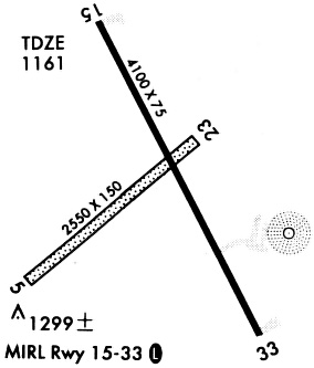
| Runways: | 05/23 15/33 |
| Longest Runway: | 15/33 is 4501 ft (1372 m) long |
| Runways with an Instrument Approach: |
KAFK Airport Runway Details
| Runway 05/23 | 2550 ft x 151 ft (777 m x 46 m) | |
| Runway Length Source: | 3RD PARTY SURVEY as of 04/15/2010 | |
| Surface: | Turf - Good condition - No special surface treatment | |
Runway 05 |
Runway 23 |
|
Elevation: |
1164.8 | 1159.9 |
Latitude: |
40-36-12.6500N | 40-36-29.7800N |
Longitude: |
095-52-18.2800W | 095-51-54.0300W |
|
Runway True Alignment: |
048 | 228 |
Glide Path Angle: |
0.0 degrees | 0.0 degrees |
| Runway 15/33 | 4501 ft x 76 ft (1372 m x 23 m) | |
| Runway Length Source: | 3RD PARTY SURVEY as of 04/15/2010 | |
| Surface: | Turf - Good condition - No special surface treatment | |
| Runway Edge Lights: | Medium Intensity | |
Runway Weight Bearing Capacity (in thousands of pounds) |
||
| Single Wheel Landing Gear: | 30.0 | |
Runway 15 |
Runway 33 |
|
Elevation: |
1156.7 | 1157.6 |
Latitude: |
40-36-44.3366N | 40-36-05.2617N |
Longitude: |
095-52-10.4422W | 095-51-42.5827W |
|
Runway True Alignment: |
151 | 331 |
Glide Path Angle: |
3.0 degrees | 3.0 degrees |
Runway Markings Type: |
Nonprecision Instrument | Nonprecision Instrument |
Runway Markings Condition: |
Good | Good |
Visual Glide Slope Indicators: |
2-Light PAPI On Left Side Of Runway | 2-Light PAPI On Left Side Of Runway |
Threshold Crossing Height: |
52 | 52 |
Services
Airframe Repair: |
None |
Powerplant Repair: |
None |
Bottled Oxygen: |
None |
Bulk Oxygen: |
None |
Fuel Available: |
100LL |
Landing Fees: |
No |
Parking: |
Tiedowns available |
Maps & Diagrams
KAFK Sectional
Flight Planning
at skyvector.com
at skyvector.com