Location
Latitude: |
37-59-04.0000N (37.984444) |
Longitude: |
099-53-39.6000W (-99.894333) |
Elevation: |
2467.0 feet MSL (752 m MSL) |
Magnetic Variation: |
4.7 E (as of April 2024 from WMM2020 model) |
Time Zone: |
UTC -6.0 (Standard Time) UTC -5.0 (Daylight Savings Time) |
From City: |
06 N.M. S of Jetmore, Kansas |
Found On: |
Wichita Chart |
FAA Region: |
ACE |
Contacts
Manager: |
Publicly owned: |
| MICHAEL ORT BOX 8 JETMORE, KS 67854 620-393-5565 |
CITY OF JETMORE BOX 8 JETMORE, KS 67854 620-357-8344 |
Operations
Airport Status: |
Operational |
Facility Use: |
Public |
Type: |
Airport |
Activation Date: |
02/1944 |
Control tower: |
No |
Attendance (Months/Days/Hours): |
Months/Days/Hours Unattended |
Boundary ARTCC: |
ZKC (Kansas City) |
Responsible ARTCC: |
ZKC (Kansas City) |
Lighting Schedule: |
SEE RMK |
Segmented Circle Indicator: |
No |
Traffic Pattern Altitude (MSL): |
3467 feet (1057 m) |
NOTAMs Facility: |
ICT |
NOTAM-D Service: |
Yes |
International Airport of Entry: |
No |
Customs Landing Rights: |
No |
Military Landing Rights: |
Yes |
Civil/Military Joint Use: |
No |
Based Aircraft
Annual Operations (as of 09/25/2020)
| Total Operations: | 600 | |
| GA Local: | 500 | 83.3% |
| GA Itinerant: | 100 | 16.7% |
Communications
| CTAF: | 122.700 |
| Unicom: | 122.700 |
- APCH/DEP CTL SVC PRVDD BY KANSAS ARTCC (ZKC) ON 125.2/285.425 (GARDEN CITY RCAG).
Fixed Based Operators (FBOs) & Fuel
(Click on a business for detail)
Please help us keep this information up to date. This is a FREE SERVICE just like everything else on Airport Guide! If you see that a business needs to be added, modified, or deleted please fill out our Update Form.
To add, modify, or delete a business click here.
Please help us keep this information up to date. This is a FREE SERVICE just like everything else on Airport Guide! If you see that a business needs to be added, modified, or deleted please fill out our Update Form.
Area Code: 620 |
| Business Name | Frequency | Phone | Fuel Grade |
|---|
Flight Service Stations
| Primary | Alternate | |
| FSS on Field: | N | |
| FSS Name (ID): | Wichita(ICT) | |
| Frequency: | ||
| Toll Free Phone: | 1-800-WX-BRIEF |
Instrument Procedures / Charts
FAA Terminal Procedures valid from 0901Z 03/21/24 to 0901Z 04/18/24.
There are various types of charts available for an airport. They are listed in the Page Type column. Here is a legend for those types:
APD - Airport Diagram
DP - Departure Procedure Charts
HOT - Hot Spots
IAP - Instrument Approach Procedure Charts
MIN - Minimums
STAR - Standard Terminal Arrival Charts
| Page Type | Page Name | Volume | Action Since Last Cycle |
|---|---|---|---|
| IAP | RNAV (GPS) RWY 17 | NC-2 | |
| IAP | RNAV (GPS) RWY 35 | NC-2 | |
| MIN | TAKEOFF MINIMUMS | NC-2 |
Terminal Procedures are only available for airports in several countries with more being added all the time. If you are looking for a specific country's charts, please send an email to support(at)airportguide.com stating the country name. This will be used to prioritize the implementation.
Navigation Aids (Navaids) near K79
| Dist (NM) | ID | Morse Code | Name | Type | Freq | True Hdg | Mag Hdg |
|---|---|---|---|---|---|---|---|
| 9.6 | DDC | _ . . _ . . _ . _ . | Dodge City | VORTAC | 108.20 | 213 | 208 |
| 39.5 | GCK | _ _ . _ . _ . _ . _ | Garden City | VORTAC | 113.30 | 264 | 259 |
| 40.3 | LQR | . _ . . _ _ . _ . _ . | Larned | NDB | 296 | 70 | 66 |
| 40.4 | GC | _ _ . _ . _ . | Pieve | NDB | 347 | 256 | 251 |
| 51.6 | GB | _ _ . _ . . . | Babsy | NDB | 419 | 71 | 67 |
| 51.9 | HIL | . . . . . . . _ . . | Hilyn | NDB | 338 | 64 | 60 |
| 55.5 | TQK | _ _ _ . _ _ . _ | Scott City | NDB | 256 | 302 | 297 |
| 56.0 | HY | . . . . _ . _ _ | Nette | NDB | 374 | 32 | 28 |
| 56.5 | PTT | . _ _ . _ _ | Pratt | NDB | 356 | 105 | 101 |
| 59.4 | HYS | . . . . _ . _ _ . . . | Hays | VORTAC | 110.40 | 29 | 25 |
| 68.5 | BFK | _ . . . . . _ . _ . _ | Buffalo | NDB | 215 | 168 | 163 |
| 73.6 | ULS | . . _ . _ . . . . . | Ulysses | NDB | 395 | 252 | 247 |
| 76.2 | LBL | . _ . . _ . . . . _ . . | Liberal | TACAN | 112.30 | 222 | 217 |
| 78.0 | HLC | . . . . . _ . . _ . _ . | Hill City | VORTAC | 113.70 | 348 | 343 |
| 79.4 | LB | . _ . . _ . . . | Panck | NDB | 383 | 219 | 214 |
| 80.3 | OEL | _ _ _ . . _ . . | Oakley | NDB | 380 | 327 | 322 |
| 81.6 | LYO | . _ . . _ . _ _ _ _ _ | Lyons | NDB | 386 | 74 | 70 |
| 85.9 | HQG | . . . . _ _ . _ _ _ . | Hugoton | NDB | 365 | 235 | 230 |
| 89.7 | JHN | . _ _ _ . . . . _ . | Bear Creek | NDB | 341 | 257 | 252 |
| 92.7 | HUT | . . . . . . _ _ | Hutchinson | VOR-DME | 116.80 | 88 | 84 |
Nearby Airports with Fuel
Notices to Airmen (NOTAMS)
Remarks
| A110-3 | NO PUBLIC TELEPHONE. |
| A110-4 | FOR CD CTC KANSAS CITY ARTCC AT 913-254-8508. |
| A14 | CITY SUPERINTENDENT. |
| A40-17/35 | RY 17/35 NSTD LIRL DUE TO SPACING & NUMBER OF LGTS. |
| A81-APT | LIRL RY 17/35 PRESET LOW INTST; CONT NGT. |
| E111 | EXISTED PRIOR TO 1959. |
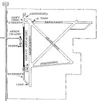
Runways
Runway Summary
| Runways: | 17/35 |
| Longest Runway: | 17/35 is 4205 ft (1282 m) long |
| Runways with an Instrument Approach: |
K79 Airport Runway Details
| Runway 17/35 | 4205 ft x 75 ft (1282 m x 23 m) | |
| Runway Length Source: | 3RD PARTY SURVEY as of 01/29/2011 | |
| Surface: | Asphalt/Concrete - Good condition - No special surface treatment | |
| Runway Edge Lights: | Low Intensity | |
Runway Weight Bearing Capacity (in thousands of pounds) |
||
| Single Wheel Landing Gear: | 15.0 | |
Runway 17 |
Runway 35 |
|
Elevation: |
2463.4 | 2466.8 |
Latitude: |
37-59-24.8130N | 37-58-43.2536N |
Longitude: |
099-53-39.1125W | 099-53-40.0588W |
|
Runway True Alignment: |
181 | 001 |
Glide Path Angle: |
0.0 degrees | 0.0 degrees |
Traffic Pattern: |
Left | Left |
Runway Markings Type: |
Nonprecision Instrument | Nonprecision Instrument |
Runway Markings Condition: |
Good | Good |
Services
Airframe Repair: |
None |
Powerplant Repair: |
None |
Fuel Available: |
100LL |
Landing Fees: |
No |
Parking: |
Tiedowns available |
Maps & Diagrams
K79 Sectional
Flight Planning
at skyvector.com
at skyvector.com