Location
Latitude: |
41-15-49.4090N (41.263725) |
Longitude: |
072-53-15.8250W (-72.887729) |
Elevation: |
12.6 feet MSL (4 m MSL) |
Magnetic Variation: |
13.2 W (as of April 2024 from WMM2020 model) |
Time Zone: |
UTC -5.0 (Standard Time) UTC -4.0 (Daylight Savings Time) |
From City: |
03 N.M. SE of New Haven, Connecticut |
Found On: |
New York Chart |
FAA Region: |
ANE |
Contacts
Manager: |
Publicly owned: |
| JEREMY NIELSON 155 BURR ST NEW HAVEN, CT 06512 203-466-8833 |
CITY OF NEW HAVEN 155 BURR ST NEW HAVEN, CT 06510 203-466-8833 |
Operations
Airport Status: |
Operational |
Facility Use: |
Public |
Type: |
Airport |
Activation Date: |
04/1940 |
Control tower: |
Yes |
Attendance (Months/Days/Hours): |
Months/Days/Hours ALL/ALL/0600-2200 |
Boundary ARTCC: |
ZNY (New York) |
Responsible ARTCC: |
ZNY (New York) |
Lighting Schedule: |
SEE RMK |
Segmented Circle Indicator: |
Yes |
Traffic Pattern Altitude (MSL): |
1013 feet (309 m) |
NOTAMs Facility: |
HVN |
NOTAM-D Service: |
Yes |
International Airport of Entry: |
No |
Customs Landing Rights: |
Yes |
Military Landing Rights: |
Yes |
Civil/Military Joint Use: |
No |
Aircraft Rescue and Firefighting: |
Class I ARFF Index: B Air Carrier Service: Scheduled Certification Date: 05/1973 |
Based Aircraft
| Single Engine: | 34 |
| Multi Engine: | 2 |
| Jet Engine: | 10 |
Annual Operations (as of 02/28/2023)
| Total Operations: | 27044 | |
| Commercial: | 6220 | 23.0% |
| Air Taxi: | 3040 | 11.2% |
| GA Local: | 6458 | 23.9% |
| GA Itinerant: | 11022 | 40.8% |
| Military Aircraft: | 304 | 1.1% |
Communications
| CTAF: | 124.800 |
| Unicom: | 122.950 |
| Tower: | NEW HAVEN 124.8 Hrs: 0600-2200 |
| Clearance Del.: | 121.7 121.7 ;WHEN HVN TWR CLSD 121.7 ;WHEN HVN TWR CLSD 121.7 ;WHEN HVN TWR CLSD 121.7 ;WHEN HVN TWR CLSD 121.7 ;WHEN HVN TWR CLSD 121.7 ;WHEN HVN TWR CLSD 121.7 ;WHEN HVN TWR CLSD |
| Ground: | 121.7 |
| Approach: | NEW YORK |
| Departure: | NEW YORK |
| ATIS: | 133.65 Hrs: 24 |
| ASOS: | (203-466-6205) |
Fixed Based Operators (FBOs) & Fuel
(Click on a business for detail)
Please help us keep this information up to date. This is a FREE SERVICE just like everything else on Airport Guide! If you see that a business needs to be added, modified, or deleted please fill out our Update Form.
To add, modify, or delete a business click here.
Please help us keep this information up to date. This is a FREE SERVICE just like everything else on Airport Guide! If you see that a business needs to be added, modified, or deleted please fill out our Update Form.
Area Code: 203 |
| Business Name | Frequency | Phone | Fuel Grade |
|---|---|---|---|
| Robinson Aviation, Inc.
Update FBO info |
Unicom 122.95 | 467-9555 | 100LL, Jet A |
| Shoreline Aviation, Inc.
Update FBO info |
468-8639 |
Flight Service Stations
| Primary | Alternate | |
| FSS on Field: | N | |
| FSS Name (ID): | Bridgeport(BDR) | |
| Frequency: | ||
| Toll Free Phone: | 1-800-WX-BRIEF |
Instrument Procedures / Charts
FAA Terminal Procedures valid from 0901Z 03/21/24 to 0901Z 04/18/24.
There are various types of charts available for an airport. They are listed in the Page Type column. Here is a legend for those types:
APD - Airport Diagram
DP - Departure Procedure Charts
HOT - Hot Spots
IAP - Instrument Approach Procedure Charts
MIN - Minimums
STAR - Standard Terminal Arrival Charts
| Page Type | Page Name | Volume | Action Since Last Cycle |
|---|---|---|---|
| APD | AIRPORT DIAGRAM | NE-1 | |
| DP | BRIDGEHAVEN ONE | NE-1 | |
| IAP | ILS OR LOC RWY 02 | NE-1 | |
| IAP | RNAV (GPS) RWY 02 | NE-1 | |
| IAP | RNAV (GPS) RWY 20 | NE-1 | |
| MIN | ALTERNATE MINIMUMS | NE-1 | |
| MIN | TAKEOFF MINIMUMS | NE-1 | |
| STAR | BRIDGEPORT ONE | NE-1 | |
| STAR | DENNA THREE | NE-1 |
Terminal Procedures are only available for airports in several countries with more being added all the time. If you are looking for a specific country's charts, please send an email to support(at)airportguide.com stating the country name. This will be used to prioritize the implementation.
Navigation Aids (Navaids) near HVN
| Dist (NM) | ID | Morse Code | Name | Type | Freq | True Hdg | Mag Hdg |
|---|---|---|---|---|---|---|---|
| 0.1 | HVN | . . . . . . . _ _ . | New Haven | DME | 109.8 | 126 | 139 |
| 9.3 | MAD | _ _ . _ _ . . | Madison | VOR-DME | 110.40 | 71 | 84 |
| 12.3 | BDR | _ . . . _ . . . _ . | Bridgeport | VOR-DME | 108.80 | 240 | 253 |
| 12.4 | BDR | _ . . . _ . . . _ . | Bridgeport | VOT | 109.25 | 240 | 253 |
| 12.4 | JWE | . _ _ _ . _ _ . | Clera | NDB | 362 | 305 | 318 |
| 20.1 | OP | _ _ _ . _ _ . | Old Field Point Light | NDB | 316 | 211 | 224 |
| 20.4 | CCC | _ . _ . _ . _ . _ . _ . | Calverton | VOR-DME | 114.55 | 168 | 181 |
| 26.2 | FO | . . _ . _ _ _ | Squir | NDB | 400 | 145 | 158 |
| 27.3 | HFD | . . . . . . _ . _ . . | Hartford | VOR-DME | 114.90 | 33 | 46 |
| 28.1 | FOK | . . _ . _ _ _ _ . _ | Suffolk Co | TACAN | 111.00 | 155 | 168 |
| 30.1 | ISP | . . . . . . _ _ . | Long Island Mac Arthur | VOT | 109.40 | 198 | 211 |
| 30.2 | HFD | . . . . . . _ . _ . . | Hartford | VOT | 108.20 | 20 | 33 |
| 31.3 | CMK | _ . _ . _ _ _ . _ | Carmel | VOR-DME | 116.60 | 272 | 285 |
| 33.1 | HTO | . . . . _ _ _ _ | Hampton | VORTAC | 113.60 | 128 | 141 |
| 34.0 | DPK | _ . . . _ _ . _ . _ | Deer Park | VOR-DME | 117.70 | 213 | 226 |
| 34.9 | IS | . . . . . | Lokks | NDB | 366 | 203 | 216 |
| 37.9 | GON | _ _ . _ _ _ _ . | Groton | VOR-DME | 110.85 | 83 | 96 |
| 37.9 | GON | _ _ . _ _ _ _ . | Groton | VOT | 110.25 | 84 | 97 |
| 39.7 | FR | . . _ . . _ . | Frikk | NDB | 407 | 222 | 235 |
| 41.1 | BDL | _ . . . _ . . . _ . . | Bradley | VOT | 111.40 | 12 | 25 |
Nearby Airports with Fuel
Notices to Airmen (NOTAMS)
Remarks
| A110-1 | NOISE ABATEMENT PROCS IN EFCT. DEPARTING RWY 20, RIGHT AND LEFT TURN MADE ONLY AFT PASSING SHORELINE. |
| A110-10 | WILDLIFE FQTLY ON OR INVOF ARPT. |
| A110-11 | TSNT PRKG ON EAST RAMP ONLY. |
| A110-16 | PAEW ADJ TO ALL OPR SFCS DALGT HRS APR-OCT. |
| A110-22 | LDG HELS USE TWYS A & H INTXN. |
| A110-23 | STANDING WATER AT INTXN OF TWY D & C AFT HVY RAIN. |
| A110-24 | FOR CD WHEN TWR CLSD CTC NEW YORK APCH AT 516-683-2449 OR 121.7. |
| A110-3 | TGL OPNS PMTD 0700-2200 MON-SAT; 0800-2200 SUN. |
| A110-4 | AVOID CLOSE-IN BASE LEGS AND SHORT APCHS LDG RWY 20. |
| A110-6 | FLT NOTIFICATION SVC (ADCUS) AVBL. |
| A110-7 | CLSD TO ACFT OVER 78 DB 0700-2200; 73 DB 2200-0000 & 0600-0700; 68 DB 0000-0600 EXCP MIL EMERG & MED ACFT; PPR CALL 203-907-9818 |
| A110-8 | EXTSV HOP SFC-10000 FT WI 20 MI NNW. |
| A17 | FUEL AVBL AFT HRS PPR 203-467-9555. |
| A24 | LDG FEE FOR ALL ACFT EXC MIL, GOVT, EMERG & MED. |
| A26 | CLSD TO UNSKED ACR OPS WITH MORE THAN 30 PAX SEATS EXCP 24 HR PPR CALL OPS 203-907-9818. |
| A81-APT | WHEN ATCT CLSD ACTVT MALSF RWY 02; HIRL RWY 02/20 - CTAF. |
| E111 | EXISTED PRIOR TO 1959. |
| E147 | TPA: 999 FT AGL RECIPROCATING ENG, 1499 FT AGL TURBOPROP/JET. |
Runways
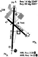
Runway Summary
| Runways: | 02/20 |
| Longest Runway: | 02/20 is 5600 ft (1707 m) long |
| Runways with an Instrument Approach: | 02 |
HVN Airport Runway Details
| Runway 02/20 | 5600 ft x 150 ft (1707 m x 46 m) | |
| Runway Length Source: | 3RD PARTY SURVEY as of 01/09/2017 | |
| Surface: | Asphalt - Excellent condition - Saw-cut or plastic grooved | |
| Runway Pavement Class: | 57 /F/C/X/T | |
| Runway Edge Lights: | High Intensity | |
Runway Weight Bearing Capacity (in thousands of pounds) |
||
| Single Wheel Landing Gear: | 110.0 | |
| Dual Wheel Landing Gear: | 160.0 | |
Runway 02 |
Runway 20 |
|
Elevation: |
6.5 | 12.6 |
Latitude: |
41-15-21.7800N | 41-16-17.0383N |
Longitude: |
072-53-17.6853W | 072-53-13.9642W |
|
Runway True Alignment: |
003 | 183 |
ILS Type: |
ILS/DME | |
Glide Path Angle: |
3.0 degrees | 3.5 degrees |
Traffic Pattern: |
Left | Left |
Runway Markings Type: |
Precision Instrument | Nonprecision Instrument |
Runway Markings Condition: |
Good | Good |
Object at End: |
TREES | TREES |
Object Height: |
36 | 55 |
Distance from End: |
1400 | 1300 |
Object Centerline Offset: |
0 ft. left and right of centerline | 0 ft. left and right of centerline |
Visual Glide Slope Indicators: |
4-Light PAPI On Left Side Of Runway | 4-Light PAPI On Left Side Of Runway |
Runway Visual Range (RVR): |
Touchdown | Rollout |
Approach Light System: |
1,400 Foot Medium Intensity Approach Lighting System With Sequenced Flashers | |
Threshold Crossing Height: |
50 | 55 |
Declared Distances |
||
Take Off Run Avbl. (TORA): |
5600 | 5600 |
Take Off Distance Avbl. (TODA): |
5600 | 5600 |
Actual Stop Dist. Avbl. (ASDA): |
5600 | 5600 |
Landing Dist. Avbl. (LDA): |
5600 | 5600 |
Services
Airframe Repair: |
Major |
Powerplant Repair: |
Major |
Bottled Oxygen: |
None |
Bulk Oxygen: |
None |
Fuel Available: |
100LL |
Landing Fees: |
No |
Parking: |
Hangars and tiedowns available |
Maps & Diagrams
HVN Sectional
Flight Planning
at skyvector.com
at skyvector.com