Location
Latitude: |
39-50-28.7130N (39.841309) |
Longitude: |
077-16-28.7400W (-77.27465) |
Elevation: |
553.2 feet MSL (169 m MSL) |
Magnetic Variation: |
10.8 W (as of April 2024 from WMM2020 model) |
Time Zone: |
UTC -5.0 (Standard Time) UTC -4.0 (Daylight Savings Time) |
From City: |
02 N.M. W of Gettysburg, Pennsylvania |
Found On: |
Washington Chart |
FAA Region: |
AEA |
Contacts
Manager: |
Publicly owned: |
| TIM EDWARDS ONE TERMINAL DRIVE, SUITE 300 MIDDLETOWN, PA 17057 717-948-3900 |
SUSQUEHANNA RGNL ARPT AUTHORITY ONE TERMINAL DRIVE, SUITE 300 MIDDLETOWN, PA 17057 717-948-3900 |
Operations
Airport Status: |
Operational |
Facility Use: |
Public |
Type: |
Airport |
Activation Date: |
07/1973 |
Control tower: |
No |
Attendance (Months/Days/Hours): |
Months/Days/Hours Unattended |
Boundary ARTCC: |
ZNY (New York) |
Responsible ARTCC: |
ZDC (Washington) |
Lighting Schedule: |
SEE RMK |
Segmented Circle Indicator: |
Yes |
Traffic Pattern Altitude (MSL): |
1553 feet (473 m) |
NOTAMs Facility: |
IPT |
NOTAM-D Service: |
Yes |
Based Aircraft
| Single Engine: | 21 |
| GA Helicopters: | 1 |
Annual Operations (as of 02/07/2023)
| Total Operations: | 9650 | |
| GA Local: | 6900 | 71.5% |
| GA Itinerant: | 2700 | 28.0% |
| Military Aircraft: | 50 | 0.5% |
Communications
| CTAF: | 122.900 |
| Approach: | POTOMAC 126.825 126.825 |
| Departure: | POTOMAC 126.825 126.825 |
Fixed Based Operators (FBOs) & Fuel
(Click on a business for detail)
Please help us keep this information up to date. This is a FREE SERVICE just like everything else on Airport Guide! If you see that a business needs to be added, modified, or deleted please fill out our Update Form.
To add, modify, or delete a business click here.
Please help us keep this information up to date. This is a FREE SERVICE just like everything else on Airport Guide! If you see that a business needs to be added, modified, or deleted please fill out our Update Form.
Area Code: 717 |
| Business Name | Frequency | Phone | Fuel Grade |
|---|---|---|---|
| Doersom's Flying Service
Update FBO info |
334-2474 | 80, 100LL |
Flight Service Stations
| Primary | Alternate | |
| FSS on Field: | N | |
| FSS Name (ID): | Williamsport(IPT) | |
| Frequency: | ||
| Toll Free Phone: | 1-800-WX-BRIEF |
Instrument Procedures / Charts
FAA Terminal Procedures valid from 0901Z 03/21/24 to 0901Z 04/18/24.
There are various types of charts available for an airport. They are listed in the Page Type column. Here is a legend for those types:
APD - Airport Diagram
DP - Departure Procedure Charts
HOT - Hot Spots
IAP - Instrument Approach Procedure Charts
MIN - Minimums
STAR - Standard Terminal Arrival Charts
| Page Type | Page Name | Volume | Action Since Last Cycle |
|---|---|---|---|
| IAP | RNAV (GPS)-A | NE-4 | |
| MIN | TAKEOFF MINIMUMS | NE-4 |
Terminal Procedures are only available for airports in several countries with more being added all the time. If you are looking for a specific country's charts, please send an email to support(at)airportguide.com stating the country name. This will be used to prioritize the implementation.
Navigation Aids (Navaids) near GTY
| Dist (NM) | ID | Morse Code | Name | Type | Freq | True Hdg | Mag Hdg |
|---|---|---|---|---|---|---|---|
| 18.9 | EUD | . . . _ _ . . | York | NDB | 254 | 75 | 86 |
| 23.7 | CX | _ . _ . _ . . _ | Latle | NDB | 219 | 31 | 42 |
| 24.9 | EMI | . _ _ . . | Westminster | VORTAC | 117.90 | 146 | 157 |
| 26.2 | FDK | . . _ . _ . . _ . _ | Frederick | VOR | 109.00 | 190 | 201 |
| 28.1 | HGR | . . . . _ _ . . _ . | Hagerstown | VOR | 109.80 | 252 | 263 |
| 29.2 | HAR | . . . . . _ . _ . | Harrisburg | VORTAC | 112.50 | 18 | 29 |
| 29.8 | MD | _ _ _ . . | Enola | NDB | 204 | 35 | 46 |
| 31.6 | THS | _ . . . . . . . | St Thomas | VORTAC | 115.00 | 280 | 291 |
| 31.7 | MDT | _ _ _ . . _ | Harrisburg | VOT | 110.00 | 47 | 58 |
| 38.1 | MRB | _ _ . _ . _ . . . | Martinsburg | VORTAC | 112.10 | 224 | 235 |
| 40.4 | FND | . . _ . _ . _ . . | Ellicott | NDB | 371 | 145 | 156 |
| 40.6 | GAI | _ _ . . _ . . | Gaithersburg | NDB | 385 | 172 | 183 |
| 44.8 | IUB | . . . . _ _ . . . | Institute | NDB | 404 | 137 | 148 |
| 48.2 | LRP | . _ . . . _ . . _ _ . | Lancaster | VOR-DME | 117.30 | 69 | 80 |
| 48.7 | BZJ | _ . . . _ _ . . . _ _ _ | Bellgrove | NDB | 328 | 42 | 53 |
| 49.2 | BAL | _ . . . . _ . _ . . | Baltimore | VORTAC | 115.10 | 144 | 155 |
| 51.3 | BUH | _ . . . . . _ . . . . | Anne Arundel | NDB | 260 | 152 | 163 |
| 52.8 | RAV | . _ . . _ . . . _ | Ravine | VORTAC | 114.60 | 35 | 46 |
| 55.1 | AML | . _ _ _ . _ . . | Armel | VOR-DME | 113.50 | 189 | 200 |
| 55.1 | GTN | _ _ . _ _ . | Georgetown | NDB | 323 | 172 | 183 |
Nearby Airports with Fuel
Notices to Airmen (NOTAMS)
Remarks
| A110-1 | DEER AND BIRDS INVOF ARPT. |
| A110-3 | FOR CD CTC POTOMAC APCH AT 866-709-4993. |
| A57-06 | APCH RATIO 39:1 TO DTHR. |
| A57-24 | RWY 24 APCH RATIO 21:1 TO DSPLCD THLD. |
| A81-APT | ACTVT MIRL RWY 06/24 - CTAF. |
Runways
Runway Summary
| Runways: | 06/24 |
| Longest Runway: | 06/24 is 3100 ft (945 m) long |
| Runways with an Instrument Approach: |
GTY Airport Runway Details
| Runway 06/24 | 3100 ft x 60 ft (945 m x 18 m) | |
| Runway Length Source: | 3RD PARTY SURVEY as of 08/03/2022 | |
| Surface: | Asphalt - Good condition - No special surface treatment | |
| Runway Edge Lights: | Medium Intensity | |
Runway 06 |
Runway 24 |
|
Elevation: |
539.8 | 552.3 |
Latitude: |
39-50-18.7695N | 39-50-38.6562N |
Longitude: |
077-16-43.8573W | 077-16-13.6208W |
|
Runway True Alignment: |
050 | 230 |
Glide Path Angle: |
0.0 degrees | 0.0 degrees |
Traffic Pattern: |
Left | Left |
Runway Markings Type: |
Nonprecision Instrument | Basic |
Runway Markings Condition: |
Good | Good |
Object at End: |
ROAD | POLE |
Object Height: |
14 | 51 |
Object Marked/Lighted?: |
Marked | |
Distance from End: |
370 | 749 |
Object Centerline Offset: |
0 ft. left and right of centerline | 118 ft. right of centerline |
Threshold Elevation: |
540.0 | 553.1 |
Displaced Threshold: |
165 | 539 |
Threshold Latitude: |
39-50-19.8279N | 39-50-35.1893N |
Threshold Longitude: |
077-16-42.2483W | 077-16-18.8922W |
Services
Airframe Repair: |
Major |
Powerplant Repair: |
Major |
Fuel Available: |
100LL, UL94 |
Landing Fees: |
No |
Parking: |
Tiedowns available |
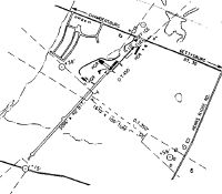
Maps & Diagrams
GTY Sectional
Flight Planning
at skyvector.com
at skyvector.com