Location
Latitude: |
31-57-04.7000N (31.951306) |
Longitude: |
085-07-44.1000W (-85.128917) |
Elevation: |
285.2 feet MSL (87 m MSL) |
Magnetic Variation: |
4.8 W (as of April 2024 from WMM2020 model) |
Time Zone: |
UTC -6.0 (Standard Time) UTC -5.0 (Daylight Savings Time) |
From City: |
03 N.M. N of Eufaula, Alabama |
Found On: |
New Orleans Chart |
FAA Region: |
ASO |
Contacts
Manager: |
Publicly owned: |
| NIKKI OGLETREE 1730 N. EUFALA AVE EUFAULA, AL 36027 334-695-0285 |
CITY OF EUFAULA BOX 219 EUFAULA, AL 36027 334-688-2000 |
Operations
Airport Status: |
Operational |
Facility Use: |
Public |
Type: |
Airport |
Control tower: |
No |
Attendance (Months/Days/Hours): |
Months/Days/Hours ALL/ALL/0800-1700 |
Boundary ARTCC: |
ZTL (Atlanta) |
Responsible ARTCC: |
ZTL (Atlanta) |
Lighting Schedule: |
SEE RMK |
Segmented Circle Indicator: |
Yes |
Traffic Pattern Altitude (MSL): |
1285 feet (392 m) |
NOTAMs Facility: |
ANB |
NOTAM-D Service: |
Yes |
International Airport of Entry: |
No |
Customs Landing Rights: |
No |
Military Landing Rights: |
Yes |
Civil/Military Joint Use: |
No |
Based Aircraft
| Single Engine: | 11 |
| Multi Engine: | 1 |
Annual Operations (as of 02/11/2020)
| Total Operations: | 36638 | |
| GA Local: | 9047 | 24.7% |
| GA Itinerant: | 18091 | 49.4% |
| Military Aircraft: | 9500 | 25.9% |
Communications
| CTAF: | 122.800 |
| Unicom: | 122.800 |
| Approach: | ATLANTA 125.5 125.5 125.5 125.5 125.5 125.5 ATLANTA ARTCC |
| Departure: | ATLANTA 125.5 125.5 125.5 125.5 125.5 125.5 ATLANTA ARTCC |
| ASOS: | 128.325 (334-687-5596) |
- APCH/DEP SVC PRVDD BY ATLANTA LARGE TRACON 125.5 (0515-2200) OTHER TIMES ATLANTA ARTCC 120.45/298.850 (COLUMBUS RCAG)
- CLNC DEL PRVDD BY ATLANTA LARGE TRACON 134.25 (0515-2200) OTHER TIMES ATLANTA ARTCC 120.45/298.850 (COLUMBUS RCAG).
Fixed Based Operators (FBOs) & Fuel
(Click on a business for detail)
Please help us keep this information up to date. This is a FREE SERVICE just like everything else on Airport Guide! If you see that a business needs to be added, modified, or deleted please fill out our Update Form.
To add, modify, or delete a business click here.
Please help us keep this information up to date. This is a FREE SERVICE just like everything else on Airport Guide! If you see that a business needs to be added, modified, or deleted please fill out our Update Form.
Area Code: 334 |
| Business Name | Frequency | Phone | Fuel Grade |
|---|---|---|---|
| Dixon Aviation, Inc.
Update FBO info |
Unicom 122.8 | 687-2051 | 100LL, Jet A |
Flight Service Stations
| Primary | Alternate | |
| FSS on Field: | N | |
| FSS Name (ID): | Anniston(ANB) | |
| Frequency: | ||
| Toll Free Phone: | 1-800-WX-BRIEF |
Instrument Procedures / Charts
FAA Terminal Procedures valid from 0901Z 03/21/24 to 0901Z 04/18/24.
There are various types of charts available for an airport. They are listed in the Page Type column. Here is a legend for those types:
APD - Airport Diagram
DP - Departure Procedure Charts
HOT - Hot Spots
IAP - Instrument Approach Procedure Charts
MIN - Minimums
STAR - Standard Terminal Arrival Charts
| Page Type | Page Name | Volume | Action Since Last Cycle |
|---|---|---|---|
| IAP | RNAV (GPS) RWY 18 | SE-4 | |
| IAP | RNAV (GPS) RWY 36 | SE-4 | |
| IAP | VOR RWY 18 | SE-4 | |
| IAP | VOR/DME RWY 36 | SE-4 | |
| MIN | TAKEOFF MINIMUMS | SE-4 |
Terminal Procedures are only available for airports in several countries with more being added all the time. If you are looking for a specific country's charts, please send an email to support(at)airportguide.com stating the country name. This will be used to prioritize the implementation.
Navigation Aids (Navaids) near EUF
| Dist (NM) | ID | Morse Code | Name | Type | Freq | True Hdg | Mag Hdg |
|---|---|---|---|---|---|---|---|
| 0.1 | EUF | . . . _ . . _ . | Eufaula | VORTAC | 109.20 | 233 | 238 |
| 21.2 | AWS | . _ . _ _ . . . | Lawson | NDB | 335 | 14 | 19 |
| 23.9 | LSF | . _ . . . . . . . _ . | Lawson | VOR-DME | 111.40 | 16 | 21 |
| 30.4 | CS | _ . _ . . . . | Fenix | NDB | 355 | 8 | 13 |
| 33.7 | IWJ | . . . _ _ . _ _ _ | Blaak | NDB | 344 | 151 | 156 |
| 40.2 | CSG | _ . _ . . . . _ _ . | Columbus | TACAN | 117.10 | 8 | 13 |
| 42.2 | TGE | _ _ _ . . | Tuskegee | VOR-DME | 117.30 | 319 | 324 |
| 42.9 | RRS | . _ . . _ . . . . | Wiregrass | VORTAC | 111.60 | 201 | 206 |
| 43.7 | HYE | . . . . _ . _ _ . | Hanchey | NDB | 221 | 217 | 222 |
| 43.8 | HEY | . . . . . _ . _ _ | Hanchey | VOR | 110.60 | 217 | 222 |
| 46.2 | PZD | . _ _ . _ _ . . _ . . | Pecan | VOR-DME | 116.10 | 112 | 117 |
| 47.3 | LOR | . _ . . _ _ _ . _ . | Lowe | NDB | 269 | 221 | 226 |
| 50.3 | TOI | _ _ _ _ . . | Blood | NDB | 365 | 261 | 266 |
| 51.1 | OZR | _ _ _ _ _ . . . _ . | Cairns | VOR-DME | 111.20 | 216 | 221 |
| 52.7 | AB | . _ _ . . . | Putny | NDB | 227 | 124 | 129 |
| 53.6 | LKG | . _ . . _ . _ _ _ . | Lindbergh | NDB | 242 | 75 | 80 |
| 55.0 | PIM | . _ _ . . . _ _ | Pine Mountain | NDB | 272 | 13 | 18 |
| 55.7 | EDN | . _ . . _ . | Enterprise | VOR | 116.60 | 225 | 230 |
| 55.9 | OZ | _ _ _ _ _ . . | Brynt | NDB | 212 | 219 | 224 |
| 57.0 | BVG | _ . . . . . . _ _ _ . | Boll Weevil | NDB | 352 | 230 | 235 |
Nearby Airports with Fuel
Notices to Airmen (NOTAMS)
Remarks
| A110-1 | LOW FLYING HELICOPTERS IN TFC PAT. |
| A110-2 | ARPT LCTD IN WILDLIFE REFUGE - CONSTANT BIRD HAZARD. |
| A16 | 334-695-0285 AFT HRS. |
| A17 | FOR SVC AFT HRS CALL 334-695-0285. |
| A81-APT | DUSK-2200. AFTER 2200, ACTVT PAPI RWYS 18 & 36; MIRL RWY 18/36 - CTAF. |
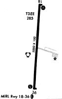
Runways
Runway Summary
| Runways: | 18/36 |
| Longest Runway: | 18/36 is 5000 ft (1524 m) long |
| Runways with an Instrument Approach: |
EUF Airport Runway Details
| Runway 18/36 | 5000 ft x 100 ft (1524 m x 30 m) | |
| Surface: | Asphalt - Good condition - No special surface treatment | |
| Runway Pavement Class: | 11 /F/A/X/T | |
| Runway Edge Lights: | Medium Intensity | |
Runway 18 |
Runway 36 |
|
Elevation: |
283.0 | 277.4 |
Latitude: |
31-57-29.4378N | 31-56-40.0553N |
Longitude: |
085-07-42.3099W | 085-07-45.9743W |
|
Runway True Alignment: |
184 | 004 |
Glide Path Angle: |
3.0 degrees | 3.0 degrees |
Traffic Pattern: |
Left | Left |
Runway Markings Type: |
Nonprecision Instrument | Nonprecision Instrument |
Runway Markings Condition: |
Good | Good |
Object at End: |
TREES | TREES |
Object Height: |
42 | 24 |
Distance from End: |
669 | 374 |
Object Centerline Offset: |
19 ft. right of centerline | 175 ft. right of centerline |
Visual Glide Slope Indicators: |
4-Light PAPI On Left Side Of Runway | 4-Light PAPI On Left Side Of Runway |
Threshold Crossing Height: |
26 | 25 |
Services
Airframe Repair: |
Major |
Powerplant Repair: |
Major |
Bottled Oxygen: |
None |
Bulk Oxygen: |
None |
Fuel Available: |
100LL, Jet A+ |
Landing Fees: |
No |
Parking: |
Hangars and tiedowns available |
Maps & Diagrams
EUF Sectional
Flight Planning
at skyvector.com
at skyvector.com